Property Record
116 Skywatch Dr, Danville, KY 40422


Property Detail
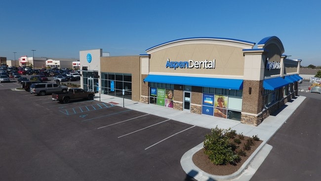
116 Skywatch Dr
D17-011-003
ASPEN DENTAL BLDG SITE
Restaurantdrivein
BOYLE
COMMERCIAL
Kentucky
B and X Area of moderate flood hazard, usually the area between the limits of the 100-year and 500-year floods.
0.41 AC
2025
Kentucky East Area
2025
Other Market Areas
930400
Danville, KY
1,818 SF
NEARBY LISTINGS FOR SALE OR LEASE
DEMOGRAPHICS near 116 Skywatch Dr
1 mile
3 mile
5 mile
2025 Total Population
3,353
19,039
25,829
2030 Population
3,428
19,453
26,395
Pop Growth 2025-2030
+ 2.24%
+ 2.17%
+ 2.19%
Average Age
42
40
41
2025 Total Households
1,479
7,634
10,024
HH Growth 2025-2030
+ 2.50%
+ 2.41%
+ 2.44%
Median Household Inc
$47,567
$50,892
$57,257
Avg Household Size
2.20
2.30
2.30
2025 Avg HH Vehicles
2.00
2.00
2.00
Median Home Value
$150,986
$199,273
$218,421
Median Year Built
1978
1975
1977
Nearby Places
Map Layers
Map Styles
 Street
 Aerial
Layers
 Traffic
 Biking
Places
Listings with unknown addresses are not visible on the map
- Restaurants
- Banks
- Shops
- Fitness
- Groceries
SALE & LEASE HISTORY
LISTING DATE
SALE/LEASE

Sep 23, 2016
For Sale
Nov 10, 2016
For Sale
Mar 31, 2017
For Sale
Nearby Properties
Address
Land Use
TOTAL SIZE
Lot Size
Zoning
Address
Land Use
TOTAL SIZE
Lot Size
Zoning
21.12 AC
Address
Land Use
TOTAL SIZE
Lot Size
Zoning
73.69 AC
Address
Land Use
TOTAL SIZE
Lot Size
Zoning
80,400 SF
59.35 AC
Address
Land Use
TOTAL SIZE
Lot Size
Zoning
Address
Land Use
TOTAL SIZE
Lot Size
Zoning
162,110 SF
28.84 AC
Address
Land Use
TOTAL SIZE
Lot Size
Zoning
Address
Land Use
TOTAL SIZE
Lot Size
Zoning
35,921 SF
8.19 AC
Address
Land Use
TOTAL SIZE
Lot Size
Zoning
Address
Land Use
TOTAL SIZE
Lot Size
Zoning
104,000 SF
39.59 AC
Address
Land Use
TOTAL SIZE
Lot Size
Zoning
Address
Land Use
TOTAL SIZE
Lot Size
Zoning
178,568 SF
24.17 AC
Address
Land Use
TOTAL SIZE
Lot Size
Zoning
6.32 AC
Address
Land Use
TOTAL SIZE
Lot Size
Zoning
195,285 SF
19.89 AC
COMMERCIAL
Address
Land Use
TOTAL SIZE
Lot Size
Zoning
29,182 SF
0.45 AC
COMMERCIAL
Address
Land Use
TOTAL SIZE
Lot Size
Zoning
705,815 SF
316.13 AC
Address
Land Use
TOTAL SIZE
Lot Size
Zoning
309,295 SF
22.36 AC
Address
Land Use
TOTAL SIZE
Lot Size
Zoning
5.40 AC
Address
Land Use
TOTAL SIZE
Lot Size
Zoning
307,746 SF
25.65 AC
Address
Land Use
TOTAL SIZE
Lot Size
Zoning
Address
Land Use
TOTAL SIZE
Lot Size
Zoning
493,456 SF
21.68 AC
Address
Land Use
TOTAL SIZE
Lot Size
Zoning
152,415 SF
24.09 AC
Address
Land Use
TOTAL SIZE
Lot Size
Zoning
15,460 SF
42.81 AC
Address
Land Use
TOTAL SIZE
Lot Size
Zoning
57,140 SF
7.03 AC
COMMERCIAL
Address
Land Use
TOTAL SIZE
Lot Size
Zoning
8,320 SF
Address
Land Use
TOTAL SIZE
Lot Size
Zoning
Address
Land Use
TOTAL SIZE
Lot Size
Zoning
3,139 SF
4.43 AC
Address
Land Use
TOTAL SIZE
Lot Size
Zoning
34,400 SF
9.78 AC
Address
Land Use
TOTAL SIZE
Lot Size
Zoning
9,000 SF
11 AC
COMMERCIAL
Address
Land Use
TOTAL SIZE
Lot Size
Zoning
9.50 AC
The World's #1 Commercial Real Estate Marketplace
Connect with us
© 2026 CoStar Group
The information above has been obtained from sources believed reliable. While we do not doubt its accuracy we have not verified it and make no guarantee, warranty or representation about it. It is your responsibility to independently confirm its accuracy and completeness. Any projections, opinions, assumptions, or estimates used are for example only and do not represent the current or future performance of the property. The value of this transaction to you depends on tax and other factors which should be evaluated by your tax, financial, and legal advisors. You and your advisors should conduct a careful, independent investigation of the property to determine to your satisfaction the suitability of the property for your needs.