Property Record
116 State St, Newburgh, IN 47630


Save to a Folder
{{folder.Name}}
{{folder.ListingIds.length}} Properties
{{folder.ListingIds.length}} Property
Create a New Folder
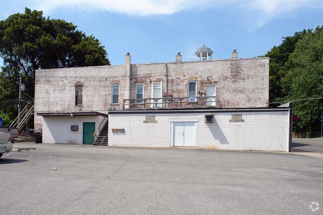
Property Detail
116 State St
Evansville, IN
LOTS 9 10 & N 2/3 LOT 8 IN PHELPS SUB OF LOTS 9 10 11 & 12 IN LOWER ENLG & N 1/2 LOT 13 IN LOWER ENLG EXC. ALLEY W 10 FT. OF
87-15-03-108-010.000-014
Warrick
Storebuilding
Indiana
B and X Area of moderate flood hazard, usually the area between the limits of the 100-year and 500-year floods.
9,8,13
2025
0.14 AC
2025
Warrick County
030801
Evansville
5,339 SF
NEARBY LISTINGS FOR SALE OR LEASE
DEMOGRAPHICS near 116 State St
1 mile
3 mile
5 mile
2025 Total Population
4,558
28,957
57,719
2030 Population
4,679
29,681
58,518
Pop Growth 2025-2030
+ 2.65%
+ 2.50%
+ 1.38%
Average Age
42
42
41
2025 Total Households
1,897
11,318
23,527
HH Growth 2025-2030
+ 2.69%
+ 2.56%
+ 1.27%
Median Household Inc
$83,862
$91,379
$80,716
Avg Household Size
2.40
2.50
2.40
2025 Avg HH Vehicles
2.00
2.00
2.00
Median Home Value
$328,057
$282,910
$268,856
Median Year Built
1980
1989
1986
Nearby Places
Map Layers
Map Styles
 Street
 Aerial
Layers
 Traffic
 Biking
Places
Listings with unknown addresses are not visible on the map
- Restaurants
- Banks
- Shops
- Fitness
- Groceries
PUBLIC TRANSPORTATION
AIRPORT
Evansville Regional
Drive
Walk
Distance
Evansville Regional
23 min
12.9 mi
Nearby Properties
Address
Land Use
TOTAL SIZE
Lot Size
Zoning
Address
Land Use
TOTAL SIZE
Lot Size
Zoning
43,824 SF
32.02 AC
Address
Land Use
TOTAL SIZE
Lot Size
Zoning
130,000 SF
Address
Land Use
TOTAL SIZE
Lot Size
Zoning
75,107 SF
13.68 AC
Address
Land Use
TOTAL SIZE
Lot Size
Zoning
30,039 SF
6.67 AC
Address
Land Use
TOTAL SIZE
Lot Size
Zoning
3,940 SF
17.67 AC
Address
Land Use
TOTAL SIZE
Lot Size
Zoning
3,260 SF
9.96 AC
Address
Land Use
TOTAL SIZE
Lot Size
Zoning
31,950 SF
6.22 AC
Address
Land Use
TOTAL SIZE
Lot Size
Zoning
130,978 SF
24.94 AC
Address
Land Use
TOTAL SIZE
Lot Size
Zoning
4,389 SF
9.09 AC
Address
Land Use
TOTAL SIZE
Lot Size
Zoning
28,632 SF
6.27 AC
Address
Land Use
TOTAL SIZE
Lot Size
Zoning
72,946 SF
2.64 AC
Address
Land Use
TOTAL SIZE
Lot Size
Zoning
197,528 SF
21.55 AC
Address
Land Use
TOTAL SIZE
Lot Size
Zoning
31,864 SF
5.40 AC
Address
Land Use
TOTAL SIZE
Lot Size
Zoning
32,117 SF
12.88 AC
Address
Land Use
TOTAL SIZE
Lot Size
Zoning
61,299 SF
2.22 AC
Address
Land Use
TOTAL SIZE
Lot Size
Zoning
99,714 SF
5 AC
Address
Land Use
TOTAL SIZE
Lot Size
Zoning
72,877 SF
9 AC
Address
Land Use
TOTAL SIZE
Lot Size
Zoning
62,912 SF
3.29 AC
Address
Land Use
TOTAL SIZE
Lot Size
Zoning
90,181 SF
10.66 AC
Address
Land Use
TOTAL SIZE
Lot Size
Zoning
88,964 SF
8.72 AC
Address
Land Use
TOTAL SIZE
Lot Size
Zoning
45,627 SF
5.89 AC
Address
Land Use
TOTAL SIZE
Lot Size
Zoning
33,899 SF
4.92 AC
Address
Land Use
TOTAL SIZE
Lot Size
Zoning
28,632 SF
1.22 AC
Address
Land Use
TOTAL SIZE
Lot Size
Zoning
52,252 SF
6.79 AC
Address
Land Use
TOTAL SIZE
Lot Size
Zoning
15,784 SF
7.06 AC
Address
Land Use
TOTAL SIZE
Lot Size
Zoning
67,043 SF
4.44 AC
Address
Land Use
TOTAL SIZE
Lot Size
Zoning
71,338 SF
6.05 AC
Address
Land Use
TOTAL SIZE
Lot Size
Zoning
24,124 SF
2.86 AC
Address
Land Use
TOTAL SIZE
Lot Size
Zoning
34,560 SF
16.85 AC
Address
Land Use
TOTAL SIZE
Lot Size
Zoning
17.15 AC
The World's #1 Commercial Real Estate Marketplace
Connect with us
© 2026 CoStar Group
The information above has been obtained from sources believed reliable. While we do not doubt its accuracy we have not verified it and make no guarantee, warranty or representation about it. It is your responsibility to independently confirm its accuracy and completeness. Any projections, opinions, assumptions, or estimates used are for example only and do not represent the current or future performance of the property. The value of this transaction to you depends on tax and other factors which should be evaluated by your tax, financial, and legal advisors. You and your advisors should conduct a careful, independent investigation of the property to determine to your satisfaction the suitability of the property for your needs.