Property Record
116 Sylvia Rd, Ashland, VA 23005


Save to a Folder
{{folder.Name}}
{{folder.ListingIds.length}} Properties
{{folder.ListingIds.length}} Property
Create a New Folder
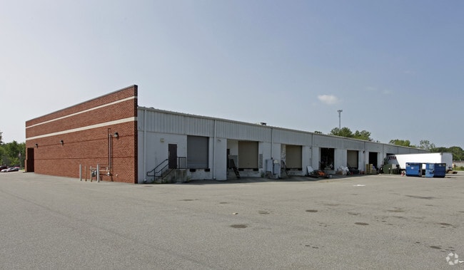
Property Detail
116 Sylvia Rd
7880-16-8151
ASHLAND PARK COMM DEVELMT LOT 58 BLK C
Commercialnec
Hanover
M-1
Virginia
B and X Area of moderate flood hazard, usually the area between the limits of the 100-year and 500-year floods.
58
2026
3.50 AC
2026
I-95 North/Ashland
320602
Richmond VA
32,850 SF
Richmond, VA
NEARBY LISTINGS FOR SALE OR LEASE
-
-
View all Ashland listings for lease on LoopNet.com
DEMOGRAPHICS near 116 Sylvia Rd
1 mile
3 mile
5 mile
2025 Total Population
3,397
12,091
18,365
2030 Population
3,516
12,590
19,171
Pop Growth 2025-2030
+ 3.50%
+ 4.13%
+ 4.39%
Average Age
34
40
41
2025 Total Households
1,084
4,478
6,867
HH Growth 2025-2030
+ 3.78%
+ 4.31%
+ 4.56%
Median Household Inc
$66,300
$89,588
$100,351
Avg Household Size
2.20
2.40
2.50
2025 Avg HH Vehicles
2.00
2.00
2.00
Median Home Value
$332,353
$385,897
$406,861
Median Year Built
1982
1983
1986
Nearby Places
Map Layers
Map Styles
 Street
 Aerial
Layers
 Traffic
 Biking
Places
Listings with unknown addresses are not visible on the map
- Restaurants
- Banks
- Shops
- Fitness
- Groceries
PUBLIC TRANSPORTATION
COMMUTER RAIL
Ashland Amtrak (Northeast Regional - Amtrak)
Drive
Walk
Distance
Ashland Amtrak (Northeast Regional - Amtrak)
4 min
1.6 mi
AIRPORT
Richmond International
Drive
Walk
Distance
Richmond International
35 min
25.8 mi
Freight Ports
Virginia Port Authority - Richmond
Drive
Walk
Distance
Virginia Port Authority - Richmond
36 min
25.4 mi
SALE & LEASE HISTORY
LISTING DATE
SALE/LEASE

Sep 25, 2016
For Lease
Mar 24, 2017
For Lease
Jun 29, 2018
For Lease
Nearby Properties
Address
Land Use
TOTAL SIZE
Lot Size
Zoning
Address
Land Use
TOTAL SIZE
Lot Size
Zoning
36.08 AC
HE
Address
Land Use
TOTAL SIZE
Lot Size
Zoning
189.83 AC
M-2
Address
Land Use
TOTAL SIZE
Lot Size
Zoning
26,583 SF
9 AC
HE
Address
Land Use
TOTAL SIZE
Lot Size
Zoning
30.94 AC
M-2
Address
Land Use
TOTAL SIZE
Lot Size
Zoning
194,598 SF
14.50 AC
R-5
Address
Land Use
TOTAL SIZE
Lot Size
Zoning
3.60 AC
HE
Address
Land Use
TOTAL SIZE
Lot Size
Zoning
320,540 SF
18.50 AC
M-2
Address
Land Use
TOTAL SIZE
Lot Size
Zoning
311,740 SF
43.40 AC
M-1
Address
Land Use
TOTAL SIZE
Lot Size
Zoning
280,900 SF
22.69 AC
M-1
Address
Land Use
TOTAL SIZE
Lot Size
Zoning
220,499 SF
19.01 AC
PSC
Address
Land Use
TOTAL SIZE
Lot Size
Zoning
293,114 SF
15.56 AC
M-2
Address
Land Use
TOTAL SIZE
Lot Size
Zoning
24.21 AC
RR-1
Address
Land Use
TOTAL SIZE
Lot Size
Zoning
215,072 SF
16.32 AC
M-2
Address
Land Use
TOTAL SIZE
Lot Size
Zoning
43.11 AC
PMH
Address
Land Use
TOTAL SIZE
Lot Size
Zoning
17.80 AC
B-3
Address
Land Use
TOTAL SIZE
Lot Size
Zoning
151,540 SF
21.15 AC
PSC
Address
Land Use
TOTAL SIZE
Lot Size
Zoning
10.50 AC
R-2
Address
Land Use
TOTAL SIZE
Lot Size
Zoning
8.73 AC
M-2
Address
Land Use
TOTAL SIZE
Lot Size
Zoning
23.97 AC
RR-1
Address
Land Use
TOTAL SIZE
Lot Size
Zoning
65,670 SF
5.97 AC
R-5
Address
Land Use
TOTAL SIZE
Lot Size
Zoning
19,454 SF
38.31 AC
HE
Address
Land Use
TOTAL SIZE
Lot Size
Zoning
136,144 SF
6.27 AC
M-2
Address
Land Use
TOTAL SIZE
Lot Size
Zoning
66,910 SF
1.94 AC
B-2
Address
Land Use
TOTAL SIZE
Lot Size
Zoning
16.20 AC
M-2
Address
Land Use
TOTAL SIZE
Lot Size
Zoning
57.31 AC
B-2
Address
Land Use
TOTAL SIZE
Lot Size
Zoning
48,622 SF
24.28 AC
POB
Address
Land Use
TOTAL SIZE
Lot Size
Zoning
110,234 SF
39.45 AC
M-3
Address
Land Use
TOTAL SIZE
Lot Size
Zoning
42,334 SF
6.59 AC
B-3
Address
Land Use
TOTAL SIZE
Lot Size
Zoning
5 AC
HE
Address
Land Use
TOTAL SIZE
Lot Size
Zoning
1.77 AC
B-2
The World's #1 Commercial Real Estate Marketplace
Connect with us
© 2026 CoStar Group
The information above has been obtained from sources believed reliable. While we do not doubt its accuracy we have not verified it and make no guarantee, warranty or representation about it. It is your responsibility to independently confirm its accuracy and completeness. Any projections, opinions, assumptions, or estimates used are for example only and do not represent the current or future performance of the property. The value of this transaction to you depends on tax and other factors which should be evaluated by your tax, financial, and legal advisors. You and your advisors should conduct a careful, independent investigation of the property to determine to your satisfaction the suitability of the property for your needs.