Property Record
116 Veterans Dr, Holland, MI 49423

NEARBY LISTINGS FOR SALE OR LEASE
Property Detail
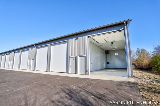
116 Veterans Dr
Holland, MI
Veterans Condominium
53-02-05-461-703
UNIT 4 116 VETERANS CONDOMINIUM SEC 5 T4N R15W TAX MAP: 0.03 AC (2022) SPLIT/COMBINED ON 02/17/2022 FROM 53-02-05-456-010;
Loftbuilding
Allegan
2024
Michigan
2025
0.03 AC
032401
NE Allegan/Holland
1,151 SF
West Michigan
DEMOGRAPHICS near 116 Veterans Dr
1 Mile
3 Mile
5 Mile
2024 Total Population
5,594
37,422
76,124
2029 Population
5,724
38,827
79,271
Pop Growth 2024-2029
+ 2.32%
+ 3.75%
+ 4.13%
Average Age
41
38
40
2024 Total Households
2,207
14,011
28,866
HH Growth 2024-2029
+ 2.17%
+ 3.83%
+ 4.26%
Median Household Inc
$67,083
$68,117
$71,272
Avg Household Size
2.40
2.40
2.50
2024 Avg HH Vehicles
2.00
2.00
2.00
Median Home Value
$206,459
$216,361
$242,026
Median Year Built
1977
1969
1979
Nearby Places
Map Layers
Map Styles
 Street
 Aerial
- Restaurants
- Banks
- Shops
- Fitness
- Groceries
PUBLIC TRANSPORTATION
COMMUTER RAIL
Holland Amtrak Station (Pere Marquette - Amtrak)
DRIVE
WALK
Distance
Holland Amtrak Station (Pere Marquette - Amtrak)
6 min
2.6 mi
Freight Ports
Port Milwaukee
DRIVE
WALK
Distance
Port Milwaukee
274 min
234.3 mi
Nearby Properties
Address
Land Use
TOTAL SIZE
Lot Size
Zoning
Address
Land Use
TOTAL SIZE
Lot Size
Zoning
1,599,294 SF
Address
Land Use
TOTAL SIZE
Lot Size
Zoning
572,832 SF
10.89 AC
PUD
Address
Land Use
TOTAL SIZE
Lot Size
Zoning
1,788,352 SF
173.33 AC
Address
Land Use
TOTAL SIZE
Lot Size
Zoning
682,378 SF
99.60 AC
NA
Address
Land Use
TOTAL SIZE
Lot Size
Zoning
198,712 SF
Address
Land Use
TOTAL SIZE
Lot Size
Zoning
630,943 SF
28.50 AC
Address
Land Use
TOTAL SIZE
Lot Size
Zoning
556,819 SF
85.45 AC
Address
Land Use
TOTAL SIZE
Lot Size
Zoning
660,002 SF
32.13 AC
I-2
Address
Land Use
TOTAL SIZE
Lot Size
Zoning
674,052 SF
79.30 AC
Address
Land Use
TOTAL SIZE
Lot Size
Zoning
154,107 SF
Address
Land Use
TOTAL SIZE
Lot Size
Zoning
239,465 SF
Address
Land Use
TOTAL SIZE
Lot Size
Zoning
118,444 SF
4.39 AC
Address
Land Use
TOTAL SIZE
Lot Size
Zoning
589,649 SF
92.65 AC
Address
Land Use
TOTAL SIZE
Lot Size
Zoning
94,790 SF
1.74 AC
C-2
Address
Land Use
TOTAL SIZE
Lot Size
Zoning
150,822 SF
Address
Land Use
TOTAL SIZE
Lot Size
Zoning
177,800 SF
12.34 AC
I-2
Address
Land Use
TOTAL SIZE
Lot Size
Zoning
114,088 SF
10.79 AC
PRD
Address
Land Use
TOTAL SIZE
Lot Size
Zoning
181,754 SF
13.44 AC
R3
Address
Land Use
TOTAL SIZE
Lot Size
Zoning
391,842 SF
28.34 AC
Address
Land Use
TOTAL SIZE
Lot Size
Zoning
228,876 SF
49.31 AC
GMU
Address
Land Use
TOTAL SIZE
Lot Size
Zoning
372,017 SF
17.60 AC
R-2
Address
Land Use
TOTAL SIZE
Lot Size
Zoning
357,000 SF
23.35 AC
Address
Land Use
TOTAL SIZE
Lot Size
Zoning
73,700 SF
Address
Land Use
TOTAL SIZE
Lot Size
Zoning
397,258 SF
36.66 AC
I2
Address
Land Use
TOTAL SIZE
Lot Size
Zoning
158,661 SF
17.28 AC
Address
Land Use
TOTAL SIZE
Lot Size
Zoning
122,026 SF
15.03 AC
R3
Address
Land Use
TOTAL SIZE
Lot Size
Zoning
146,357 SF
20.04 AC
Address
Land Use
TOTAL SIZE
Lot Size
Zoning
73,663 SF
4.66 AC
Address
Land Use
TOTAL SIZE
Lot Size
Zoning
252,065 SF
13.98 AC
Address
Land Use
TOTAL SIZE
Lot Size
Zoning
404,600 SF
23.23 AC
I2
The World's #1 Commercial Real Estate Marketplace
Connect with us
© 2025 CoStar Group
The information above has been obtained from sources believed reliable. While we do not doubt its accuracy we have not verified it and make no guarantee, warranty or representation about it. It is your responsibility to independently confirm its accuracy and completeness. Any projections, opinions, assumptions, or estimates used are for example only and do not represent the current or future performance of the property. The value of this transaction to you depends on tax and other factors which should be evaluated by your tax, financial, and legal advisors. You and your advisors should conduct a careful, independent investigation of the property to determine to your satisfaction the suitability of the property for your needs.