Property Record
116 W 8Th St, Aspinwall, PA 15215

Property Detail
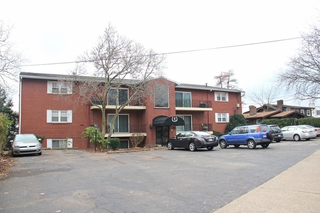
116 W 8Th St
Pittsburgh, PA
ASPINWALL LD CO PLAN PT 412 LOT 107.96XAVG122.3 3X100 RR 8TH ST 2 STY BRK & C B & STUCCO APT BLDG 116
0169-L-00133-0000-00
Allegheny
Apartment
Pennsylvania
B and X Area of moderate flood hazard, usually the area between the limits of the 100-year and 500-year floods.
133
2024
0.29 AC
2025
Aspinwall
423000
Pittsburgh
NEARBY LISTINGS FOR SALE OR LEASE
DEMOGRAPHICS near 116 W 8Th St
1 mile
3 mile
5 mile
2025 Total Population
5,864
77,564
255,684
2030 Population
5,694
77,344
254,283
Pop Growth 2025-2030
(2.90%)
(0.28%)
(0.55%)
Average Age
43
42
40
2025 Total Households
2,477
36,599
117,090
HH Growth 2025-2030
(3.19%)
(0.33%)
(0.66%)
Median Household Inc
$116,306
$70,945
$69,713
Avg Household Size
2.30
2.00
2.00
2025 Avg HH Vehicles
2.00
1.00
1.00
Median Home Value
$397,192
$269,036
$262,810
Median Year Built
1948
1950
1952
Nearby Places
Map Layers
Map Styles
 Street
 Aerial
Transit
 Traffic
 Biking
Places
Listings with unknown addresses are not visible on the map
- Restaurants
- Banks
- Shops
- Fitness
- Groceries
PUBLIC TRANSPORTATION
COMMUTER RAIL
Drive
Walk
Distance
15 min
7.9 mi
AIRPORT
Pittsburgh International
Drive
Walk
Distance
Pittsburgh International
39 min
24.8 mi
Arnold Palmer Regional
Drive
Walk
Distance
Arnold Palmer Regional
66 min
44.4 mi
Nearby Properties
Address
Land Use
TOTAL SIZE
Lot Size
Zoning
Address
Land Use
TOTAL SIZE
Lot Size
Zoning
363.56 AC
Address
Land Use
TOTAL SIZE
Lot Size
Zoning
48.57 AC
Address
Land Use
TOTAL SIZE
Lot Size
Zoning
17.75 AC
Address
Land Use
TOTAL SIZE
Lot Size
Zoning
41.36 AC
Address
Land Use
TOTAL SIZE
Lot Size
Zoning
160.63 AC
Address
Land Use
TOTAL SIZE
Lot Size
Zoning
4.10 AC
Address
Land Use
TOTAL SIZE
Lot Size
Zoning
1.22 AC
Address
Land Use
TOTAL SIZE
Lot Size
Zoning
4,242 SF
115.01 AC
Address
Land Use
TOTAL SIZE
Lot Size
Zoning
91.02 AC
Address
Land Use
TOTAL SIZE
Lot Size
Zoning
82.74 AC
Address
Land Use
TOTAL SIZE
Lot Size
Zoning
1.34 AC
Address
Land Use
TOTAL SIZE
Lot Size
Zoning
28.95 AC
Address
Land Use
TOTAL SIZE
Lot Size
Zoning
Address
Land Use
TOTAL SIZE
Lot Size
Zoning
2.92 AC
Address
Land Use
TOTAL SIZE
Lot Size
Zoning
12.93 AC
Address
Land Use
TOTAL SIZE
Lot Size
Zoning
Address
Land Use
TOTAL SIZE
Lot Size
Zoning
10.45 AC
Address
Land Use
TOTAL SIZE
Lot Size
Zoning
33.39 AC
Address
Land Use
TOTAL SIZE
Lot Size
Zoning
0.86 AC
Address
Land Use
TOTAL SIZE
Lot Size
Zoning
Address
Land Use
TOTAL SIZE
Lot Size
Zoning
18.49 AC
Address
Land Use
TOTAL SIZE
Lot Size
Zoning
13.37 AC
Address
Land Use
TOTAL SIZE
Lot Size
Zoning
1,490 SF
129.81 AC
Address
Land Use
TOTAL SIZE
Lot Size
Zoning
3.12 AC
Address
Land Use
TOTAL SIZE
Lot Size
Zoning
5.05 AC
Address
Land Use
TOTAL SIZE
Lot Size
Zoning
Address
Land Use
TOTAL SIZE
Lot Size
Zoning
Address
Land Use
TOTAL SIZE
Lot Size
Zoning
4,836 SF
30.63 AC
Address
Land Use
TOTAL SIZE
Lot Size
Zoning
2.92 AC
Address
Land Use
TOTAL SIZE
Lot Size
Zoning
15.61 AC
The World's #1 Commercial Real Estate Marketplace
Connect with us
© 2026 CoStar Group
The information above has been obtained from sources believed reliable. While we do not doubt its accuracy we have not verified it and make no guarantee, warranty or representation about it. It is your responsibility to independently confirm its accuracy and completeness. Any projections, opinions, assumptions, or estimates used are for example only and do not represent the current or future performance of the property. The value of this transaction to you depends on tax and other factors which should be evaluated by your tax, financial, and legal advisors. You and your advisors should conduct a careful, independent investigation of the property to determine to your satisfaction the suitability of the property for your needs.