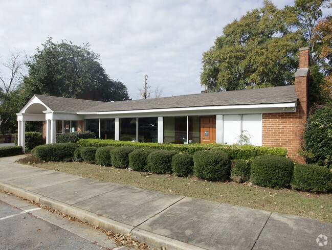
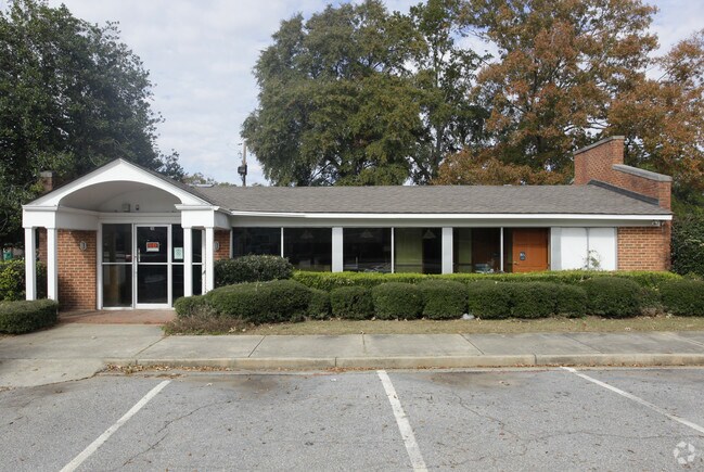
Property Record
116 Walnut St, Montezuma, GA 31063

Property Detail
116 Walnut St
Drugstorepharmacycvswalgreens
SUBWAY - LT & BLDG
002
Macon
B and X Area of moderate flood hazard, usually the area between the limits of the 100-year and 500-year floods.
Georgia
2025
0.43 AC
2025
Georgia South Area
000400
Other Market Areas
2,400 SF
4035C-0004
NEARBY LISTINGS FOR SALE OR LEASE
-
-
View all Montezuma listings for sale on LoopNet.com
DEMOGRAPHICS near 116 Walnut St
1 mile
3 mile
5 mile
2025 Total Population
2,294
4,554
6,580
2030 Population
2,285
4,467
6,459
Pop Growth 2025-2030
(0.39%)
(1.91%)
(1.84%)
Average Age
41
42
42
2025 Total Households
951
1,859
2,404
HH Growth 2025-2030
(0.11%)
(1.78%)
(1.96%)
Median Household Inc
$39,389
$42,934
$41,593
Avg Household Size
2.40
2.30
2.40
2025 Avg HH Vehicles
2.00
2.00
2.00
Median Home Value
$90,992
$87,822
$89,789
Median Year Built
1982
1980
1981
Nearby Places
Map Layers
Map Styles
 Street
 Aerial
Transit
 Traffic
 Biking
Places
Listings with unknown addresses are not visible on the map
- Restaurants
- Banks
- Shops
- Fitness
- Groceries
SALE & LEASE HISTORY
LISTING DATE
SALE/LEASE

Sep 24, 2016
For Sale
Nearby Properties
Address
Land Use
TOTAL SIZE
Lot Size
Zoning
Address
Land Use
TOTAL SIZE
Lot Size
Zoning
197,136 SF
18 AC
007
Address
Land Use
TOTAL SIZE
Lot Size
Zoning
61,580 SF
6.60 AC
003
Address
Land Use
TOTAL SIZE
Lot Size
Zoning
108,241 SF
59.96 AC
002
Address
Land Use
TOTAL SIZE
Lot Size
Zoning
68,121 SF
19.55 AC
002
Address
Land Use
TOTAL SIZE
Lot Size
Zoning
33,870 SF
0.28 AC
007
Address
Land Use
TOTAL SIZE
Lot Size
Zoning
17.31 AC
007
Address
Land Use
TOTAL SIZE
Lot Size
Zoning
31,056 SF
0.52 AC
007
Address
Land Use
TOTAL SIZE
Lot Size
Zoning
11,916 SF
18.50 AC
007
Address
Land Use
TOTAL SIZE
Lot Size
Zoning
5,731 SF
2.90 AC
C
Address
Land Use
TOTAL SIZE
Lot Size
Zoning
77,429 SF
8.39 AC
C
Address
Land Use
TOTAL SIZE
Lot Size
Zoning
63,708 SF
4.42 AC
I
Address
Land Use
TOTAL SIZE
Lot Size
Zoning
13,056 SF
9 AC
AG-2
Address
Land Use
TOTAL SIZE
Lot Size
Zoning
14.27 AC
002
Address
Land Use
TOTAL SIZE
Lot Size
Zoning
10,432 SF
2.09 AC
007
Address
Land Use
TOTAL SIZE
Lot Size
Zoning
30,434 SF
2.22 AC
C
Address
Land Use
TOTAL SIZE
Lot Size
Zoning
4,368 SF
3.26 AC
007
Address
Land Use
TOTAL SIZE
Lot Size
Zoning
21.95 AC
R-1
Address
Land Use
TOTAL SIZE
Lot Size
Zoning
380.94 AC
007
Address
Land Use
TOTAL SIZE
Lot Size
Zoning
14,312 SF
1.43 AC
007
Address
Land Use
TOTAL SIZE
Lot Size
Zoning
16,080 SF
4.84 AC
001
Address
Land Use
TOTAL SIZE
Lot Size
Zoning
404.08 AC
007
Address
Land Use
TOTAL SIZE
Lot Size
Zoning
11,372 SF
2.56 AC
007
Address
Land Use
TOTAL SIZE
Lot Size
Zoning
2,400 SF
299.12 AC
R-1
Address
Land Use
TOTAL SIZE
Lot Size
Zoning
10,318 SF
1.98 AC
C
Address
Land Use
TOTAL SIZE
Lot Size
Zoning
9,940 SF
0.75 AC
007
Address
Land Use
TOTAL SIZE
Lot Size
Zoning
166,698 SF
13.34 AC
I
Address
Land Use
TOTAL SIZE
Lot Size
Zoning
4,728 SF
0.78 AC
007
Address
Land Use
TOTAL SIZE
Lot Size
Zoning
19,200 SF
7.62 AC
002
Address
Land Use
TOTAL SIZE
Lot Size
Zoning
24,060 SF
0.45 AC
002
Address
Land Use
TOTAL SIZE
Lot Size
Zoning
9,528 SF
2.21 AC
007
The World's #1 Commercial Real Estate Marketplace
Connect with us
© 2026 CoStar Group
The information above has been obtained from sources believed reliable. While we do not doubt its accuracy we have not verified it and make no guarantee, warranty or representation about it. It is your responsibility to independently confirm its accuracy and completeness. Any projections, opinions, assumptions, or estimates used are for example only and do not represent the current or future performance of the property. The value of this transaction to you depends on tax and other factors which should be evaluated by your tax, financial, and legal advisors. You and your advisors should conduct a careful, independent investigation of the property to determine to your satisfaction the suitability of the property for your needs.