Property Record
1150 Broadway, Saugus, MA 01906

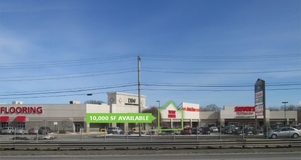
Current Lease Availabilities
NEARBY LISTINGS FOR SALE OR LEASE
-
-
-
-
-
-
880-910 Broadway, Saugus, MA 01906, USA Broadway
Saugus, MA 01906
Negotiable
2,003 - 7,069 SF
Retail
-
-
View all Saugus listings for lease on LoopNet.com
Property Detail
1150 Broadway
SAUG-000007D-000005-000001
Essex
Storebuilding
Massachusetts
AE
1
25009C0509H
4.05 AC
2025
Saugus/Lynn
2025
Boston
208200
Boston-Cambridge-Newton, MA-NH
74,346 SF
DEMOGRAPHICS near 1150 Broadway
1 mile
3 mile
5 mile
2024 Total Population
10,585
132,154
436,599
2029 Population
10,553
129,391
424,379
Pop Growth 2024-2029
(0.30%)
(2.09%)
(2.80%)
Average Age
44
40
39
2024 Total Households
4,310
49,981
163,418
HH Growth 2024-2029
(0.42%)
(2.20%)
(2.81%)
Median Household Inc
$79,601
$94,390
$82,932
Avg Household Size
2.40
2.60
2.60
2024 Avg HH Vehicles
2.00
2.00
2.00
Median Home Value
$521,494
$592,694
$578,646
Median Year Built
1960
1954
1952
Nearby Places
Map Layers
Map Styles
 Street
 Aerial
Transit
 Traffic
 Biking
Places
Listings with unknown addresses are not visible on the map
- Restaurants
- Banks
- Shops
- Fitness
- Groceries
PUBLIC TRANSPORTATION
COMMUTER RAIL
Melrose/Cedar Park (Haverhill Line - Massachusetts Bay Transportation Authority Commuter Rail (Purple Line))
Drive
Walk
Distance
Melrose/Cedar Park (Haverhill Line - Massachusetts Bay Transportation Authority Commuter Rail (Purple Line))
7 min
3.0 mi
Wyoming Hill (Haverhill Line - Massachusetts Bay Transportation Authority Commuter Rail (Purple Line))
Drive
Walk
Distance
Wyoming Hill (Haverhill Line - Massachusetts Bay Transportation Authority Commuter Rail (Purple Line))
7 min
3.0 mi
AIRPORT
General Edward Lawrence Logan International
Drive
Walk
Distance
General Edward Lawrence Logan International
17 min
9.2 mi
Nearby Properties
Address
Land Use
TOTAL SIZE
Lot Size
Zoning
Address
Land Use
TOTAL SIZE
Lot Size
Zoning
8 AC
HB
Address
Land Use
TOTAL SIZE
Lot Size
Zoning
6.73 AC
HB
Address
Land Use
TOTAL SIZE
Lot Size
Zoning
19,308 SF
82.36 AC
NA
Address
Land Use
TOTAL SIZE
Lot Size
Zoning
195,446 SF
12.98 AC
R2
Address
Land Use
TOTAL SIZE
Lot Size
Zoning
194,880 SF
35.42 AC
NA
Address
Land Use
TOTAL SIZE
Lot Size
Zoning
359,892 SF
9.06 AC
Address
Land Use
TOTAL SIZE
Lot Size
Zoning
6.02 AC
TED
Address
Land Use
TOTAL SIZE
Lot Size
Zoning
269,070 SF
21.74 AC
NA
Address
Land Use
TOTAL SIZE
Lot Size
Zoning
330,020 SF
7.32 AC
NA
Address
Land Use
TOTAL SIZE
Lot Size
Zoning
362,970 SF
8.36 AC
BH
Address
Land Use
TOTAL SIZE
Lot Size
Zoning
241,299 SF
10.26 AC
RB
Address
Land Use
TOTAL SIZE
Lot Size
Zoning
334,150 SF
28 AC
NA
Address
Land Use
TOTAL SIZE
Lot Size
Zoning
144,848 SF
13.85 AC
IP
Address
Land Use
TOTAL SIZE
Lot Size
Zoning
5.15 AC
Address
Land Use
TOTAL SIZE
Lot Size
Zoning
8.47 AC
PC
Address
Land Use
TOTAL SIZE
Lot Size
Zoning
14.69 AC
RESC
Address
Land Use
TOTAL SIZE
Lot Size
Zoning
196,356 SF
6.20 AC
RQ1
Address
Land Use
TOTAL SIZE
Lot Size
Zoning
11.80 AC
Address
Land Use
TOTAL SIZE
Lot Size
Zoning
169,840 SF
16.70 AC
NA
Address
Land Use
TOTAL SIZE
Lot Size
Zoning
3.99 AC
Address
Land Use
TOTAL SIZE
Lot Size
Zoning
14.52 AC
RESC
Address
Land Use
TOTAL SIZE
Lot Size
Zoning
514,553 SF
57.16 AC
R4
Address
Land Use
TOTAL SIZE
Lot Size
Zoning
267,277 SF
60 AC
MD
Address
Land Use
TOTAL SIZE
Lot Size
Zoning
24.85 AC
R4
Address
Land Use
TOTAL SIZE
Lot Size
Zoning
213,000 SF
2.97 AC
RESA
Address
Land Use
TOTAL SIZE
Lot Size
Zoning
4.58 AC
HB
Address
Land Use
TOTAL SIZE
Lot Size
Zoning
228,797 SF
10.61 AC
MD
Address
Land Use
TOTAL SIZE
Lot Size
Zoning
77.43 AC
RESA
Address
Land Use
TOTAL SIZE
Lot Size
Zoning
128,416 SF
3.36 AC
RQ1
The World's #1 Commercial Real Estate Marketplace
Connect with us
© 2026 CoStar Group
The information above has been obtained from sources believed reliable. While we do not doubt its accuracy we have not verified it and make no guarantee, warranty or representation about it. It is your responsibility to independently confirm its accuracy and completeness. Any projections, opinions, assumptions, or estimates used are for example only and do not represent the current or future performance of the property. The value of this transaction to you depends on tax and other factors which should be evaluated by your tax, financial, and legal advisors. You and your advisors should conduct a careful, independent investigation of the property to determine to your satisfaction the suitability of the property for your needs.