Property Record
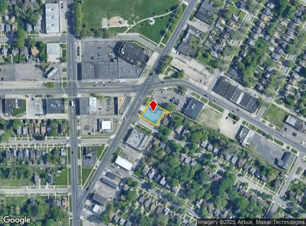
11600 Kelly Rd, Detroit, MI 48224
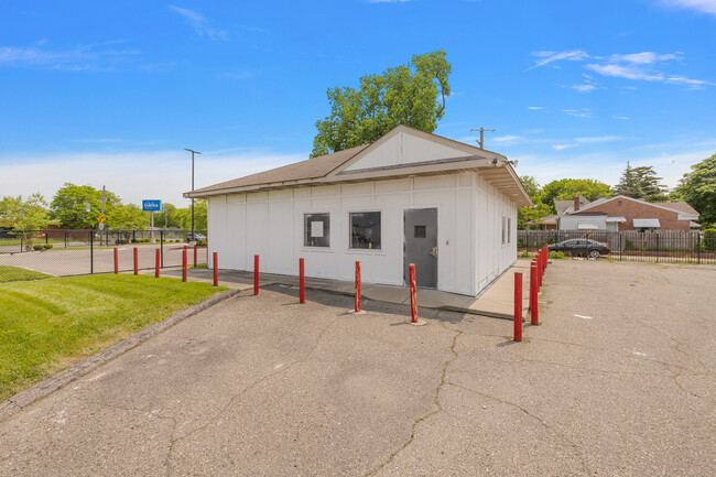
This Property Is For Sale
Current Lease Availabilities
NEARBY LISTINGS FOR SALE OR LEASE
Property Detail
11600 Kelly Rd
21-0568247
Roneys Super Highway
Storebuilding
E KELLY RD 42 THRU 38 RONEYS SUPER-HIGHWAY SUB L54 P16 PLATS, W C R 21/893 104.22 IRREG
X
Wayne
26163C0140F
Michigan
2024
0.25 AC
2025
Detroit E of Woodward
501100
Detroit
1,296 SF
Detroit-Warren-Dearborn, MI
DEMOGRAPHICS near 11600 Kelly Rd
1 Mile
3 Mile
5 Mile
2024 Total Population
24,047
160,161
350,299
2029 Population
25,279
162,837
352,079
Pop Growth 2024-2029
+ 5.12%
+ 1.67%
+ 0.51%
Average Age
36
37
39
2024 Total Households
8,331
58,423
134,005
HH Growth 2024-2029
+ 5.14%
+ 1.55%
+ 0.49%
Median Household Inc
$37,228
$42,368
$47,029
Avg Household Size
2.80
2.70
2.50
2024 Avg HH Vehicles
1.00
1.00
1.00
Median Home Value
$61,311
$86,122
$116,836
Median Year Built
1949
1951
1952
Nearby Places
- Restaurants
- Banks
- Shops
- Fitness
- Groceries
PUBLIC TRANSPORTATION
COMMUTER RAIL
DRIVE
WALK
Distance
14 min
7.7 mi
AIRPORT
Windsor International
DRIVE
WALK
Distance
Windsor International
39 min
19.2 mi
Detroit Metro Wayne County
DRIVE
WALK
Distance
Detroit Metro Wayne County
43 min
28.7 mi
Nearby Properties
Address
Land Use
TOTAL SIZE
Lot Size
Zoning
Address
Land Use
TOTAL SIZE
Lot Size
Zoning
1,034,990 SF
28.60 AC
Address
Land Use
TOTAL SIZE
Lot Size
Zoning
2,005,073 SF
108.66 AC
M4
Address
Land Use
TOTAL SIZE
Lot Size
Zoning
482,649 SF
M4
Address
Land Use
TOTAL SIZE
Lot Size
Zoning
575,081 SF
8.53 AC
R6
Address
Land Use
TOTAL SIZE
Lot Size
Zoning
182,866 SF
5.08 AC
PD
Address
Land Use
TOTAL SIZE
Lot Size
Zoning
101,733 SF
1.10 AC
C-2
Address
Land Use
TOTAL SIZE
Lot Size
Zoning
358,327 SF
M4
Address
Land Use
TOTAL SIZE
Lot Size
Zoning
302,305 SF
M4
Address
Land Use
TOTAL SIZE
Lot Size
Zoning
156,352 SF
2.72 AC
B-3
Address
Land Use
TOTAL SIZE
Lot Size
Zoning
72,940 SF
83.37 AC
M4
Address
Land Use
TOTAL SIZE
Lot Size
Zoning
26,068 SF
5.57 AC
B-2
Address
Land Use
TOTAL SIZE
Lot Size
Zoning
36,417 SF
0.68 AC
B4
Address
Land Use
TOTAL SIZE
Lot Size
Zoning
130,276 SF
6.24 AC
M-2
Address
Land Use
TOTAL SIZE
Lot Size
Zoning
80,320 SF
4.73 AC
RM-1
Address
Land Use
TOTAL SIZE
Lot Size
Zoning
233,876 SF
8.20 AC
Address
Land Use
TOTAL SIZE
Lot Size
Zoning
49,807 SF
0.84 AC
PD
Address
Land Use
TOTAL SIZE
Lot Size
Zoning
10,908 SF
2.78 AC
B-3
Address
Land Use
TOTAL SIZE
Lot Size
Zoning
92,610 SF
1.76 AC
B-3
Address
Land Use
TOTAL SIZE
Lot Size
Zoning
36,086 SF
2.05 AC
B2
Address
Land Use
TOTAL SIZE
Lot Size
Zoning
55,321 SF
4.01 AC
PD
Address
Land Use
TOTAL SIZE
Lot Size
Zoning
176,106 SF
11.95 AC
M4
Address
Land Use
TOTAL SIZE
Lot Size
Zoning
101,814 SF
3.74 AC
R-2
Address
Land Use
TOTAL SIZE
Lot Size
Zoning
60,484 SF
4.85 AC
PD
Address
Land Use
TOTAL SIZE
Lot Size
Zoning
28,444 SF
0.97 AC
B-3
Address
Land Use
TOTAL SIZE
Lot Size
Zoning
116,099 SF
5.73 AC
M-2
Address
Land Use
TOTAL SIZE
Lot Size
Zoning
87,000 SF
2.93 AC
B4
Address
Land Use
TOTAL SIZE
Lot Size
Zoning
43,967 SF
2.80 AC
O-1
Address
Land Use
TOTAL SIZE
Lot Size
Zoning
16.16 AC
PD
Address
Land Use
TOTAL SIZE
Lot Size
Zoning
137,284 SF
13.55 AC
RS-1
Address
Land Use
TOTAL SIZE
Lot Size
Zoning
12,960 SF
3.98 AC
RM-1
The World's #1 Commercial Real Estate Marketplace
Connect with us
© 2025 CoStar Group
The information above has been obtained from sources believed reliable. While we do not doubt its accuracy we have not verified it and make no guarantee, warranty or representation about it. It is your responsibility to independently confirm its accuracy and completeness. Any projections, opinions, assumptions, or estimates used are for example only and do not represent the current or future performance of the property. The value of this transaction to you depends on tax and other factors which should be evaluated by your tax, financial, and legal advisors. You and your advisors should conduct a careful, independent investigation of the property to determine to your satisfaction the suitability of the property for your needs.