Property Record
11601 Maumelle Blvd, North Little Rock, AR 72113

NEARBY LISTINGS FOR SALE OR LEASE
Property Detail
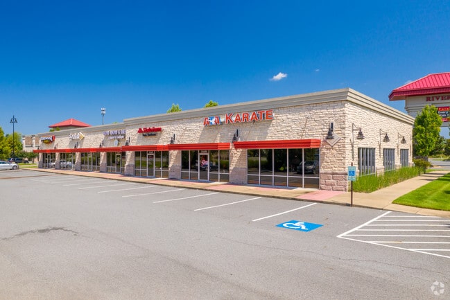
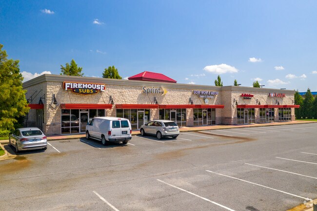
11601 Maumelle Blvd
Little Rock-North Little Rock-Conway, AR
Riverpointe Plaza
43N-010-03-001-00
TRACT 1
Regionalshoppingcenterormallwithanchorstore
Pulaski
X
Arkansas
05119C0309G
1
2025
9.84 AC
2025
Outlying Pulaski County
004307
Little Rock/N Little Rock
26,796 SF
DEMOGRAPHICS near 11601 Maumelle Blvd
1 Mile
3 Mile
5 Mile
2024 Total Population
5,371
22,682
78,871
2029 Population
5,344
22,434
78,036
Pop Growth 2024-2029
(0.50%)
(1.09%)
(1.06%)
Average Age
34
39
40
2024 Total Households
2,765
10,313
34,993
HH Growth 2024-2029
(0.40%)
(1.05%)
(1.04%)
Median Household Inc
$48,379
$64,633
$72,994
Avg Household Size
1.90
2.20
2.20
2024 Avg HH Vehicles
2.00
2.00
2.00
Median Home Value
$273,589
$267,794
$258,350
Median Year Built
2009
1998
1985
Nearby Places
Map Layers
Map Styles
 Street
 Aerial
- Restaurants
- Banks
- Shops
- Fitness
- Groceries
PUBLIC TRANSPORTATION
AIRPORT
Bill and Hillary Clinton Ntl/Adams Field
DRIVE
WALK
Distance
Bill and Hillary Clinton Ntl/Adams Field
24 min
16.1 mi
SALE & LEASE HISTORY
LISTING DATE
SALE/LEASE

Oct 19, 2016
For Lease
Nearby Properties
Address
Land Use
TOTAL SIZE
Lot Size
Zoning
Address
Land Use
TOTAL SIZE
Lot Size
Zoning
1,160,360 SF
119.55 AC
Address
Land Use
TOTAL SIZE
Lot Size
Zoning
28,414 SF
80.25 AC
Address
Land Use
TOTAL SIZE
Lot Size
Zoning
320,000 SF
91.54 AC
Address
Land Use
TOTAL SIZE
Lot Size
Zoning
89,847 SF
12.77 AC
Address
Land Use
TOTAL SIZE
Lot Size
Zoning
124,774 SF
21.05 AC
Address
Land Use
TOTAL SIZE
Lot Size
Zoning
35,712 SF
19.92 AC
Address
Land Use
TOTAL SIZE
Lot Size
Zoning
1,974 SF
14.30 AC
Address
Land Use
TOTAL SIZE
Lot Size
Zoning
80,720 SF
15.62 AC
Address
Land Use
TOTAL SIZE
Lot Size
Zoning
43,928 SF
26.72 AC
Address
Land Use
TOTAL SIZE
Lot Size
Zoning
73,197 SF
12.09 AC
Address
Land Use
TOTAL SIZE
Lot Size
Zoning
293,057 SF
20.78 AC
Address
Land Use
TOTAL SIZE
Lot Size
Zoning
55,997 SF
11.51 AC
Address
Land Use
TOTAL SIZE
Lot Size
Zoning
114,269 SF
12.85 AC
Address
Land Use
TOTAL SIZE
Lot Size
Zoning
83,352 SF
6.90 AC
Address
Land Use
TOTAL SIZE
Lot Size
Zoning
77,478 SF
38.22 AC
Address
Land Use
TOTAL SIZE
Lot Size
Zoning
65,208 SF
18.30 AC
Address
Land Use
TOTAL SIZE
Lot Size
Zoning
18,904 SF
12.73 AC
Address
Land Use
TOTAL SIZE
Lot Size
Zoning
69,251 SF
24.10 AC
Address
Land Use
TOTAL SIZE
Lot Size
Zoning
12,077 SF
27.97 AC
Address
Land Use
TOTAL SIZE
Lot Size
Zoning
484,932 SF
32.85 AC
Address
Land Use
TOTAL SIZE
Lot Size
Zoning
157,500 SF
54.99 AC
Address
Land Use
TOTAL SIZE
Lot Size
Zoning
63,140 SF
14.22 AC
Address
Land Use
TOTAL SIZE
Lot Size
Zoning
155,000 SF
12 AC
Address
Land Use
TOTAL SIZE
Lot Size
Zoning
2,340 SF
37.56 AC
Address
Land Use
TOTAL SIZE
Lot Size
Zoning
192,104 SF
34.51 AC
Address
Land Use
TOTAL SIZE
Lot Size
Zoning
93,503 SF
34.50 AC
Address
Land Use
TOTAL SIZE
Lot Size
Zoning
139,444 SF
7.63 AC
Address
Land Use
TOTAL SIZE
Lot Size
Zoning
42,313 SF
5.17 AC
Address
Land Use
TOTAL SIZE
Lot Size
Zoning
8,624 SF
10.37 AC
Address
Land Use
TOTAL SIZE
Lot Size
Zoning
39,082 SF
3.62 AC
The World's #1 Commercial Real Estate Marketplace
Connect with us
© 2026 CoStar Group
The information above has been obtained from sources believed reliable. While we do not doubt its accuracy we have not verified it and make no guarantee, warranty or representation about it. It is your responsibility to independently confirm its accuracy and completeness. Any projections, opinions, assumptions, or estimates used are for example only and do not represent the current or future performance of the property. The value of this transaction to you depends on tax and other factors which should be evaluated by your tax, financial, and legal advisors. You and your advisors should conduct a careful, independent investigation of the property to determine to your satisfaction the suitability of the property for your needs.