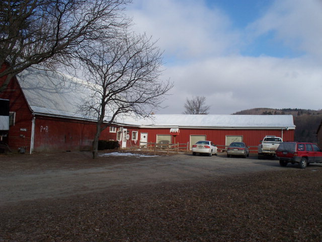
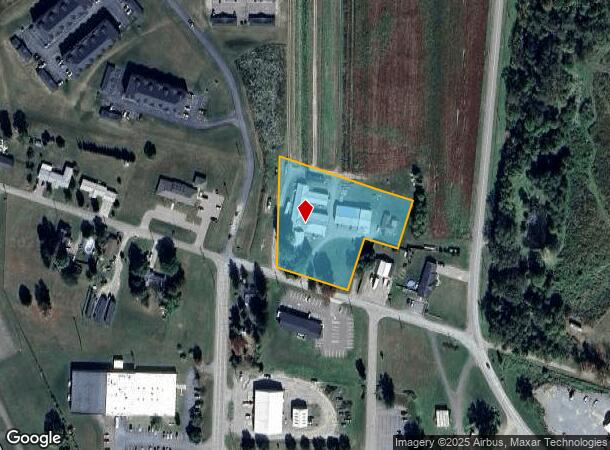
Property Record
1161 Airport Rd, Hornell, NY 14843
NEARBY LISTINGS FOR SALE OR LEASE
-
-
View all Hornell listings for sale on LoopNet.com
Property Detail
1161 Airport Rd
465289-122-000-0001-011-116
Steuben
Warehouse
New York
2025
11.116
2024
2.33 AC
960600
Other Market Areas
12,848 SF
Corning, NY
DEMOGRAPHICS near 1161 Airport Rd
1 Mile
3 Mile
5 Mile
2024 Total Population
812
3,404
12,633
2029 Population
791
3,319
12,372
Pop Growth 2024-2029
(2.59%)
(2.50%)
(2.07%)
Average Age
48
47
42
2024 Total Households
372
1,520
5,478
HH Growth 2024-2029
(2.69%)
(2.50%)
(2.10%)
Median Household Inc
$56,527
$55,817
$50,342
Avg Household Size
2.10
2.20
2.20
2024 Avg HH Vehicles
2.00
2.00
2.00
Median Home Value
$123,162
$125,605
$94,824
Median Year Built
1957
1960
1949
Nearby Places
- Restaurants
- Banks
- Shops
- Fitness
- Groceries
SALE & LEASE HISTORY
LISTING DATE
SALE/LEASE

Jan 27, 2017
For Sale
Jan 26, 2018
For Sale
Nearby Properties
Address
Land Use
TOTAL SIZE
Lot Size
Zoning
Address
Land Use
TOTAL SIZE
Lot Size
Zoning
146,000 SF
7.35 AC
I-1
Address
Land Use
TOTAL SIZE
Lot Size
Zoning
81,633 SF
13.10 AC
B-2
Address
Land Use
TOTAL SIZE
Lot Size
Zoning
128,268 SF
16.67 AC
B-2
Address
Land Use
TOTAL SIZE
Lot Size
Zoning
104,026 SF
20.66 AC
08
Address
Land Use
TOTAL SIZE
Lot Size
Zoning
111,348 SF
34.66 AC
B-2
Address
Land Use
TOTAL SIZE
Lot Size
Zoning
114,774 SF
12.11 AC
05
Address
Land Use
TOTAL SIZE
Lot Size
Zoning
77,265 SF
35.46 AC
05
Address
Land Use
TOTAL SIZE
Lot Size
Zoning
51,919 SF
4 AC
B-2
Address
Land Use
TOTAL SIZE
Lot Size
Zoning
27.85 AC
I-2
Address
Land Use
TOTAL SIZE
Lot Size
Zoning
50,883 SF
32 AC
08
Address
Land Use
TOTAL SIZE
Lot Size
Zoning
9.87 AC
Address
Land Use
TOTAL SIZE
Lot Size
Zoning
25.68 AC
Address
Land Use
TOTAL SIZE
Lot Size
Zoning
49,040 SF
15.20 AC
06
Address
Land Use
TOTAL SIZE
Lot Size
Zoning
800 SF
15.71 AC
05
Address
Land Use
TOTAL SIZE
Lot Size
Zoning
55,137 SF
7.64 AC
Address
Land Use
TOTAL SIZE
Lot Size
Zoning
10,492 SF
11.65 AC
R-3
Address
Land Use
TOTAL SIZE
Lot Size
Zoning
62,484 SF
5.40 AC
I-2
Address
Land Use
TOTAL SIZE
Lot Size
Zoning
103,138 SF
17.50 AC
05
Address
Land Use
TOTAL SIZE
Lot Size
Zoning
5,184 SF
18.50 AC
05
Address
Land Use
TOTAL SIZE
Lot Size
Zoning
13,350 SF
1.50 AC
05
Address
Land Use
TOTAL SIZE
Lot Size
Zoning
12.80 AC
05
Address
Land Use
TOTAL SIZE
Lot Size
Zoning
Address
Land Use
TOTAL SIZE
Lot Size
Zoning
Address
Land Use
TOTAL SIZE
Lot Size
Zoning
9,737 SF
14 AC
05
Address
Land Use
TOTAL SIZE
Lot Size
Zoning
1,456 SF
10.90 AC
05
Address
Land Use
TOTAL SIZE
Lot Size
Zoning
15,544 SF
3.07 AC
05
Address
Land Use
TOTAL SIZE
Lot Size
Zoning
18,206 SF
9.38 AC
08
Address
Land Use
TOTAL SIZE
Lot Size
Zoning
3,023 SF
87.83 AC
R-3
Address
Land Use
TOTAL SIZE
Lot Size
Zoning
6,516 SF
0.44 AC
B-2
Address
Land Use
TOTAL SIZE
Lot Size
Zoning
15,600 SF
3.54 AC
05
The World's #1 Commercial Real Estate Marketplace
Connect with us
© 2025 CoStar Group
The information above has been obtained from sources believed reliable. While we do not doubt its accuracy we have not verified it and make no guarantee, warranty or representation about it. It is your responsibility to independently confirm its accuracy and completeness. Any projections, opinions, assumptions, or estimates used are for example only and do not represent the current or future performance of the property. The value of this transaction to you depends on tax and other factors which should be evaluated by your tax, financial, and legal advisors. You and your advisors should conduct a careful, independent investigation of the property to determine to your satisfaction the suitability of the property for your needs.