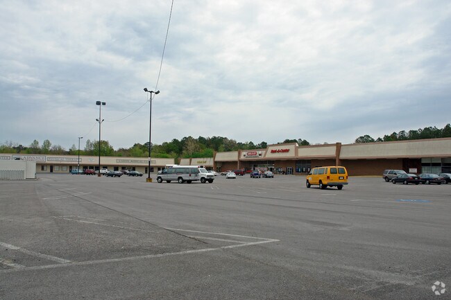
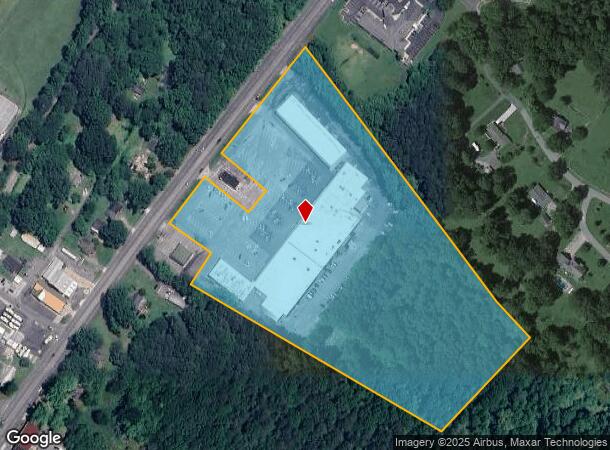
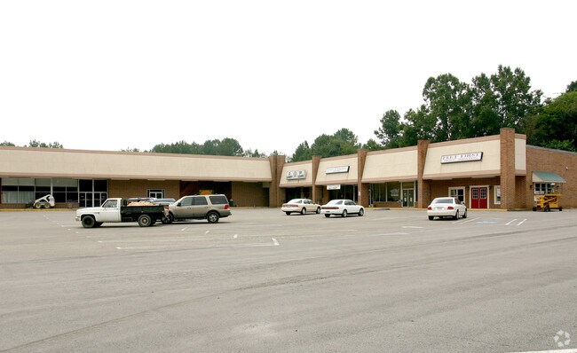
Property Record
11610 Highway 27, Summerville, GA 30747
NEARBY LISTINGS FOR SALE OR LEASE
Property Detail
11610 Highway 27
Summerville, GA
Ff-Com: 450
00049-00000-050-000 01
E OF US 27 N OF SUMMERVIL
Stripcommercialcenter
Chattooga
X
Georgia
13115C0075E
80
2024
14.82 AC
2024
Georgia Northwest
010501
Other Market Areas
68,021 SF
DEMOGRAPHICS near 11610 Highway 27
1 Mile
3 Mile
5 Mile
2024 Total Population
2,402
11,416
16,230
2029 Population
2,371
11,314
16,112
Pop Growth 2024-2029
(1.29%)
(0.89%)
(0.73%)
Average Age
41
40
40
2024 Total Households
839
4,142
5,993
HH Growth 2024-2029
(1.43%)
(0.94%)
(0.80%)
Median Household Inc
$32,301
$34,908
$36,714
Avg Household Size
2.40
2.40
2.50
2024 Avg HH Vehicles
2.00
2.00
2.00
Median Home Value
$94,491
$88,224
$85,389
Median Year Built
1973
1972
1972
Nearby Places
Map Layers
Map Styles
 Street
 Aerial
- Restaurants
- Banks
- Shops
- Fitness
- Groceries
Nearby Properties
Address
Land Use
TOTAL SIZE
Lot Size
Zoning
Address
Land Use
TOTAL SIZE
Lot Size
Zoning
1,603 SF
1.43 AC
Address
Land Use
TOTAL SIZE
Lot Size
Zoning
110,296 SF
26 AC
Address
Land Use
TOTAL SIZE
Lot Size
Zoning
156,276 SF
19.67 AC
Address
Land Use
TOTAL SIZE
Lot Size
Zoning
29,868 SF
74.50 AC
Address
Land Use
TOTAL SIZE
Lot Size
Zoning
62,543 SF
5.28 AC
Address
Land Use
TOTAL SIZE
Lot Size
Zoning
111,596 SF
51.85 AC
Address
Land Use
TOTAL SIZE
Lot Size
Zoning
10,860 SF
5.85 AC
Address
Land Use
TOTAL SIZE
Lot Size
Zoning
67,607 SF
8.06 AC
Address
Land Use
TOTAL SIZE
Lot Size
Zoning
71,679 SF
39.24 AC
Address
Land Use
TOTAL SIZE
Lot Size
Zoning
2,400 SF
7 AC
Address
Land Use
TOTAL SIZE
Lot Size
Zoning
6,494 SF
14.47 AC
Address
Land Use
TOTAL SIZE
Lot Size
Zoning
10,782 SF
1.33 AC
Address
Land Use
TOTAL SIZE
Lot Size
Zoning
51,799 SF
7.29 AC
Address
Land Use
TOTAL SIZE
Lot Size
Zoning
11,240 SF
26.74 AC
Address
Land Use
TOTAL SIZE
Lot Size
Zoning
18,960 SF
4.83 AC
Address
Land Use
TOTAL SIZE
Lot Size
Zoning
12,036 SF
1.83 AC
Address
Land Use
TOTAL SIZE
Lot Size
Zoning
2,230 SF
7 AC
Address
Land Use
TOTAL SIZE
Lot Size
Zoning
Address
Land Use
TOTAL SIZE
Lot Size
Zoning
71,568 SF
6.80 AC
Address
Land Use
TOTAL SIZE
Lot Size
Zoning
3,180 SF
2.13 AC
Address
Land Use
TOTAL SIZE
Lot Size
Zoning
12,064 SF
1.30 AC
Address
Land Use
TOTAL SIZE
Lot Size
Zoning
Address
Land Use
TOTAL SIZE
Lot Size
Zoning
6,900 SF
1.23 AC
Address
Land Use
TOTAL SIZE
Lot Size
Zoning
689.50 AC
Address
Land Use
TOTAL SIZE
Lot Size
Zoning
664.44 AC
Address
Land Use
TOTAL SIZE
Lot Size
Zoning
2,988 SF
2.60 AC
Address
Land Use
TOTAL SIZE
Lot Size
Zoning
4.62 AC
Address
Land Use
TOTAL SIZE
Lot Size
Zoning
6,726 SF
1.50 AC
Address
Land Use
TOTAL SIZE
Lot Size
Zoning
9,600 SF
0.73 AC
The World's #1 Commercial Real Estate Marketplace
Connect with us
© 2026 CoStar Group
The information above has been obtained from sources believed reliable. While we do not doubt its accuracy we have not verified it and make no guarantee, warranty or representation about it. It is your responsibility to independently confirm its accuracy and completeness. Any projections, opinions, assumptions, or estimates used are for example only and do not represent the current or future performance of the property. The value of this transaction to you depends on tax and other factors which should be evaluated by your tax, financial, and legal advisors. You and your advisors should conduct a careful, independent investigation of the property to determine to your satisfaction the suitability of the property for your needs.