Property Record
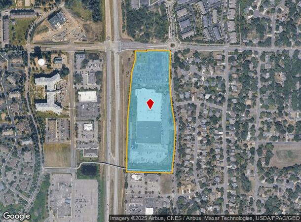
11611 Business Park Blvd N, Champlin, MN 55316


NEARBY LISTINGS FOR SALE OR LEASE
Property Detail
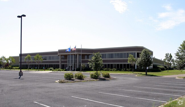
11611 Business Park Blvd N
Minneapolis-St. Paul-Bloomington, MN-WI
Westwood North 3Rd Addn
31-120-21-12-0073
LOT 001 BLOCK 001 T WESTWOOD NORTH 3RD ADDN EX HWY IRREGULAR
Industrialgeneral
Hennepin
X
Minnesota
27053C0067F
1
2024
14.96 AC
2024
Northwest
026908
Minneapolis/St Paul
DEMOGRAPHICS near 11611 Business Park Blvd N
1 Mile
3 Mile
5 Mile
2024 Total Population
9,210
63,179
169,710
2029 Population
8,991
63,367
171,052
Pop Growth 2024-2029
(2.38%)
+ 0.30%
+ 0.79%
Average Age
41
41
40
2024 Total Households
3,494
24,196
63,586
HH Growth 2024-2029
(2.46%)
+ 0.50%
+ 0.88%
Median Household Inc
$97,592
$89,777
$89,766
Avg Household Size
2.60
2.50
2.60
2024 Avg HH Vehicles
2.00
2.00
2.00
Median Home Value
$283,908
$295,652
$294,077
Median Year Built
1987
1983
1986
Nearby Places
Map Layers
Map Styles
 Street
 Aerial
- Restaurants
- Banks
- Shops
- Fitness
- Groceries
PUBLIC TRANSPORTATION
COMMUTER RAIL
Anoka Station (Northstar Corridor - Northstar Commuter Rail)
DRIVE
WALK
Distance
Anoka Station (Northstar Corridor - Northstar Commuter Rail)
8 min
3.8 mi
Coon Rapids-Riverdale Station (Northstar Corridor - Northstar Commuter Rail)
DRIVE
WALK
Distance
Coon Rapids-Riverdale Station (Northstar Corridor - Northstar Commuter Rail)
11 min
5.5 mi
AIRPORT
Minneapolis-St Paul International/Wold-Chamberlain
DRIVE
WALK
Distance
Minneapolis-St Paul International/Wold-Chamberlain
44 min
32.1 mi
Freight Ports
Port Milwaukee
DRIVE
WALK
Distance
Port Milwaukee
394 min
357.0 mi
Nearby Properties
Address
Land Use
TOTAL SIZE
Lot Size
Zoning
Address
Land Use
TOTAL SIZE
Lot Size
Zoning
517,619 SF
3.85 AC
Address
Land Use
TOTAL SIZE
Lot Size
Zoning
468,099 SF
5.73 AC
MSMU
Address
Land Use
TOTAL SIZE
Lot Size
Zoning
69.46 AC
Address
Land Use
TOTAL SIZE
Lot Size
Zoning
3.80 AC
Address
Land Use
TOTAL SIZE
Lot Size
Zoning
Address
Land Use
TOTAL SIZE
Lot Size
Zoning
42.65 AC
Address
Land Use
TOTAL SIZE
Lot Size
Zoning
Address
Land Use
TOTAL SIZE
Lot Size
Zoning
319,826 SF
37.97 AC
Address
Land Use
TOTAL SIZE
Lot Size
Zoning
Address
Land Use
TOTAL SIZE
Lot Size
Zoning
4.99 AC
Address
Land Use
TOTAL SIZE
Lot Size
Zoning
Address
Land Use
TOTAL SIZE
Lot Size
Zoning
14.72 AC
Address
Land Use
TOTAL SIZE
Lot Size
Zoning
129,060 SF
10.21 AC
Address
Land Use
TOTAL SIZE
Lot Size
Zoning
13.63 AC
Address
Land Use
TOTAL SIZE
Lot Size
Zoning
12.28 AC
Address
Land Use
TOTAL SIZE
Lot Size
Zoning
167 SF
4.73 AC
Address
Land Use
TOTAL SIZE
Lot Size
Zoning
Address
Land Use
TOTAL SIZE
Lot Size
Zoning
12.59 AC
Address
Land Use
TOTAL SIZE
Lot Size
Zoning
Address
Land Use
TOTAL SIZE
Lot Size
Zoning
11.19 AC
Address
Land Use
TOTAL SIZE
Lot Size
Zoning
15.23 AC
Address
Land Use
TOTAL SIZE
Lot Size
Zoning
Address
Land Use
TOTAL SIZE
Lot Size
Zoning
13.44 AC
Address
Land Use
TOTAL SIZE
Lot Size
Zoning
12.38 AC
Address
Land Use
TOTAL SIZE
Lot Size
Zoning
Address
Land Use
TOTAL SIZE
Lot Size
Zoning
159,335 SF
13.64 AC
Address
Land Use
TOTAL SIZE
Lot Size
Zoning
10.35 AC
Address
Land Use
TOTAL SIZE
Lot Size
Zoning
14.27 AC
Address
Land Use
TOTAL SIZE
Lot Size
Zoning
11.82 AC
Address
Land Use
TOTAL SIZE
Lot Size
Zoning
11.55 AC
The World's #1 Commercial Real Estate Marketplace
Connect with us
© 2026 CoStar Group
The information above has been obtained from sources believed reliable. While we do not doubt its accuracy we have not verified it and make no guarantee, warranty or representation about it. It is your responsibility to independently confirm its accuracy and completeness. Any projections, opinions, assumptions, or estimates used are for example only and do not represent the current or future performance of the property. The value of this transaction to you depends on tax and other factors which should be evaluated by your tax, financial, and legal advisors. You and your advisors should conduct a careful, independent investigation of the property to determine to your satisfaction the suitability of the property for your needs.