Property Record
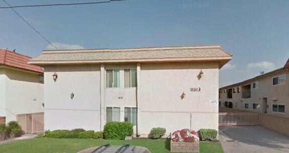
11613 Downey Ave, Downey, CA 90241


Property Detail
11613 Downey Ave
Los Angeles-Long Beach-Glendale, CA
RANCHO SANTA GERTRUDES FINALLY CONFIRMEDTO J P MCFARLAND AND J G DOWNEY 0.447 MORE OR LESS AC COM N 31 10' E 75 FT FROM MOST S COR OF LOT 55 TRACT NO 13240SEE ASSESSOR MAPBOOK FOR MISSING PORTIONTH SW THEREON 75 FT TH N 58 50' E TO BEG
6255-013-021
Los Angeles
Multifamilydwelling
California
DOR3*
55
2024
0.44 AC
2025
Downey
551300
Los Angeles
12,050 SF
NEARBY LISTINGS FOR SALE OR LEASE
DEMOGRAPHICS near 11613 Downey Ave
1 mile
3 mile
5 mile
2025 Total Population
32,990
256,762
727,389
2030 Population
32,676
253,770
714,557
Pop Growth 2025-2030
(0.95%)
(1.17%)
(1.76%)
Average Age
39
38
38
2025 Total Households
10,308
72,215
198,048
HH Growth 2025-2030
(1.15%)
(1.38%)
(1.99%)
Median Household Inc
$79,264
$83,426
$78,004
Avg Household Size
3.10
3.40
3.50
2025 Avg HH Vehicles
2.00
2.00
2.00
Median Home Value
$761,238
$732,377
$705,619
Median Year Built
1959
1958
1958
Nearby Places
Map Layers
Map Styles
 Street
 Aerial
Layers
 Traffic
 Biking
Places
Listings with unknown addresses are not visible on the map
- Restaurants
- Banks
- Shops
- Fitness
- Groceries
PUBLIC TRANSPORTATION
COMMUTER RAIL
Commerce (91 Line - Southern California Regional Rail Authority (Metrolink), Orange County Line - Southern California Regional Rail Authority (Metrolink))
Drive
Walk
Distance
Commerce (91 Line - Southern California Regional Rail Authority (Metrolink), Orange County Line - Southern California Regional Rail Authority (Metrolink))
10 min
5.1 mi
Norwalk/Santa Fe Springs (91 Line - Southern California Regional Rail Authority (Metrolink), Orange County Line - Southern California Regional Rail Authority (Metrolink))
Drive
Walk
Distance
Norwalk/Santa Fe Springs (91 Line - Southern California Regional Rail Authority (Metrolink), Orange County Line - Southern California Regional Rail Authority (Metrolink))
10 min
5.2 mi
AIRPORT
Long Beach (Daugherty Field)
Drive
Walk
Distance
Long Beach (Daugherty Field)
21 min
9.8 mi
Los Angeles International
Drive
Walk
Distance
Los Angeles International
27 min
19.2 mi
Bob Hope
Drive
Walk
Distance
Bob Hope
39 min
28.3 mi
Nearby Properties
Address
Land Use
TOTAL SIZE
Lot Size
Zoning
Address
Land Use
TOTAL SIZE
Lot Size
Zoning
1,339,758 SF
28.53 AC
DOM2-P*
Address
Land Use
TOTAL SIZE
Lot Size
Zoning
313,224 SF
4.41 AC
SGM2*
Address
Land Use
TOTAL SIZE
Lot Size
Zoning
383,495 SF
11.60 AC
DOR3PUD*
Address
Land Use
TOTAL SIZE
Lot Size
Zoning
730,731 SF
14.89 AC
BFCG*
Address
Land Use
TOTAL SIZE
Lot Size
Zoning
51,000 SF
27.18 AC
SGM3
Address
Land Use
TOTAL SIZE
Lot Size
Zoning
267,736 SF
9.04 AC
BGC4*
Address
Land Use
TOTAL SIZE
Lot Size
Zoning
609,466 SF
19.83 AC
CMM2*
Address
Land Use
TOTAL SIZE
Lot Size
Zoning
371,464 SF
9.28 AC
DOM2-P*
Address
Land Use
TOTAL SIZE
Lot Size
Zoning
332,504 SF
7.76 AC
DOHM
Address
Land Use
TOTAL SIZE
Lot Size
Zoning
105,586 SF
9.96 AC
SGM3*
Address
Land Use
TOTAL SIZE
Lot Size
Zoning
298,629 SF
6.93 AC
BGMPD*
Address
Land Use
TOTAL SIZE
Lot Size
Zoning
244,390 SF
12.99 AC
CMM2
Address
Land Use
TOTAL SIZE
Lot Size
Zoning
106,028 SF
6.42 AC
DOM2-P*
Address
Land Use
TOTAL SIZE
Lot Size
Zoning
378,720 SF
13.08 AC
SGM3*
Address
Land Use
TOTAL SIZE
Lot Size
Zoning
122,184 SF
4.03 AC
DOC2*
Address
Land Use
TOTAL SIZE
Lot Size
Zoning
99,674 SF
6.53 AC
DOM2-P*
Address
Land Use
TOTAL SIZE
Lot Size
Zoning
382,083 SF
10.77 AC
CMM1*
Address
Land Use
TOTAL SIZE
Lot Size
Zoning
624,452 SF
Address
Land Use
TOTAL SIZE
Lot Size
Zoning
165,401 SF
2.70 AC
DOC3-OSCC*
Address
Land Use
TOTAL SIZE
Lot Size
Zoning
97,600 SF
4.93 AC
CUM2*
Address
Land Use
TOTAL SIZE
Lot Size
Zoning
97,200 SF
4.81 AC
BGMPD*
Address
Land Use
TOTAL SIZE
Lot Size
Zoning
155,384 SF
11.59 AC
DOM2-P*
Address
Land Use
TOTAL SIZE
Lot Size
Zoning
183,128 SF
10.77 AC
PAM2*
Address
Land Use
TOTAL SIZE
Lot Size
Zoning
193,451 SF
6.31 AC
DOM2*
Address
Land Use
TOTAL SIZE
Lot Size
Zoning
89,760 SF
3.67 AC
DOM2*
Address
Land Use
TOTAL SIZE
Lot Size
Zoning
111,746 SF
4.38 AC
DOM2-P*
Address
Land Use
TOTAL SIZE
Lot Size
Zoning
439,058 SF
8.57 AC
DOM2*
Address
Land Use
TOTAL SIZE
Lot Size
Zoning
135,142 SF
3.76 AC
PRRM*
Address
Land Use
TOTAL SIZE
Lot Size
Zoning
100,400 SF
5.43 AC
PRIL*
Address
Land Use
TOTAL SIZE
Lot Size
Zoning
82,199 SF
3.12 AC
MNM2*
The World's #1 Commercial Real Estate Marketplace
Connect with us
© 2026 CoStar Group
The information above has been obtained from sources believed reliable. While we do not doubt its accuracy we have not verified it and make no guarantee, warranty or representation about it. It is your responsibility to independently confirm its accuracy and completeness. Any projections, opinions, assumptions, or estimates used are for example only and do not represent the current or future performance of the property. The value of this transaction to you depends on tax and other factors which should be evaluated by your tax, financial, and legal advisors. You and your advisors should conduct a careful, independent investigation of the property to determine to your satisfaction the suitability of the property for your needs.