Property Record
1163 S Harris St, Sandersville, GA 31082

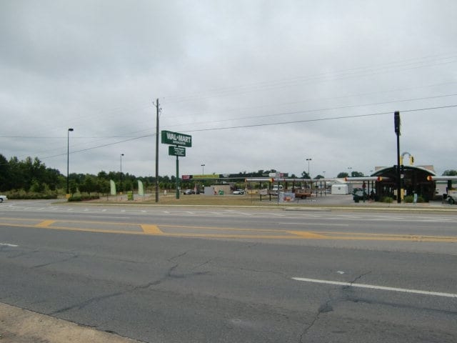
NEARBY LISTINGS FOR SALE OR LEASE
Property Detail
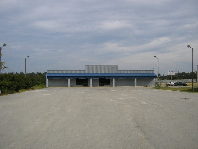
1163 S Harris St
S25 013A
Comm-Harris St 0-1999
Wholesaleoutletdiscountstore
LOWE ELECTRIC/FORMERLY FREDS
X
Washington
13303C0258C
Georgia
2024
1.85 AC
2025
Georgia South Area
950300
Other Market Areas
18,225 SF
DEMOGRAPHICS near 1163 S Harris St
1 Mile
3 Mile
5 Mile
2024 Total Population
1,061
8,407
11,098
2029 Population
1,052
8,252
10,856
Pop Growth 2024-2029
(0.85%)
(1.84%)
(2.18%)
Average Age
37
40
40
2024 Total Households
388
3,381
4,455
HH Growth 2024-2029
(1.03%)
(1.92%)
(2.24%)
Median Household Inc
$32,019
$36,427
$37,082
Avg Household Size
2.50
2.40
2.40
2024 Avg HH Vehicles
1.00
2.00
2.00
Median Home Value
$94,285
$92,363
$102,261
Median Year Built
1986
1980
1981
Nearby Places
Map Layers
Map Styles
 Street
 Aerial
- Restaurants
- Banks
- Shops
- Fitness
- Groceries
Nearby Properties
Address
Land Use
TOTAL SIZE
Lot Size
Zoning
Address
Land Use
TOTAL SIZE
Lot Size
Zoning
65.52 AC
INDUSTRIAL
Address
Land Use
TOTAL SIZE
Lot Size
Zoning
140,927 SF
44.93 AC
RURAL
Address
Land Use
TOTAL SIZE
Lot Size
Zoning
INDUSTRIAL
Address
Land Use
TOTAL SIZE
Lot Size
Zoning
495 SF
20 AC
RESIDENTIA
Address
Land Use
TOTAL SIZE
Lot Size
Zoning
158,111 SF
21.12 AC
COMMERCIAL
Address
Land Use
TOTAL SIZE
Lot Size
Zoning
65,290 SF
27.86 AC
COMMERCIAL
Address
Land Use
TOTAL SIZE
Lot Size
Zoning
17,850 SF
38.51 AC
RURAL
Address
Land Use
TOTAL SIZE
Lot Size
Zoning
4,800 SF
290.29 AC
RESIDENTIA
Address
Land Use
TOTAL SIZE
Lot Size
Zoning
150,271 SF
16.52 AC
COMMERCIAL
Address
Land Use
TOTAL SIZE
Lot Size
Zoning
1,520 SF
29.97 AC
INDUSTRIAL
Address
Land Use
TOTAL SIZE
Lot Size
Zoning
31.10 AC
COMMERCIAL
Address
Land Use
TOTAL SIZE
Lot Size
Zoning
341 SF
INDUSTRIAL
Address
Land Use
TOTAL SIZE
Lot Size
Zoning
20,962 SF
2.07 AC
COMMERCIAL
Address
Land Use
TOTAL SIZE
Lot Size
Zoning
26,436 SF
21.27 AC
COMMERCIAL
Address
Land Use
TOTAL SIZE
Lot Size
Zoning
2,343 SF
21.24 AC
INDUSTRIAL
Address
Land Use
TOTAL SIZE
Lot Size
Zoning
12,162 SF
3.32 AC
COMMERCIAL
Address
Land Use
TOTAL SIZE
Lot Size
Zoning
25,014 SF
9.57 AC
COMMERCIAL
Address
Land Use
TOTAL SIZE
Lot Size
Zoning
41,900 SF
6.69 AC
RESIDENTIA
Address
Land Use
TOTAL SIZE
Lot Size
Zoning
10,000 SF
23.62 AC
INDUSTRIAL
Address
Land Use
TOTAL SIZE
Lot Size
Zoning
14,802 SF
4.63 AC
COMMERCIAL
Address
Land Use
TOTAL SIZE
Lot Size
Zoning
15,000 SF
51.06 AC
COMMERCIAL
Address
Land Use
TOTAL SIZE
Lot Size
Zoning
Address
Land Use
TOTAL SIZE
Lot Size
Zoning
4,152 SF
2.06 AC
RESIDENTIA
Address
Land Use
TOTAL SIZE
Lot Size
Zoning
600 SF
6.78 AC
INDUSTRIAL
Address
Land Use
TOTAL SIZE
Lot Size
Zoning
75,000 SF
19.70 AC
COMMERCIAL
Address
Land Use
TOTAL SIZE
Lot Size
Zoning
2,525 SF
11.59 AC
COMMERCIAL
Address
Land Use
TOTAL SIZE
Lot Size
Zoning
36,100 SF
20.22 AC
COMMERCIAL
Address
Land Use
TOTAL SIZE
Lot Size
Zoning
3.14 AC
COMMERCIAL
Address
Land Use
TOTAL SIZE
Lot Size
Zoning
16,875 SF
45.58 AC
RESIDENTIA
Address
Land Use
TOTAL SIZE
Lot Size
Zoning
1,192 SF
182 AC
COMMERCIAL
The World's #1 Commercial Real Estate Marketplace
Connect with us
© 2026 CoStar Group
The information above has been obtained from sources believed reliable. While we do not doubt its accuracy we have not verified it and make no guarantee, warranty or representation about it. It is your responsibility to independently confirm its accuracy and completeness. Any projections, opinions, assumptions, or estimates used are for example only and do not represent the current or future performance of the property. The value of this transaction to you depends on tax and other factors which should be evaluated by your tax, financial, and legal advisors. You and your advisors should conduct a careful, independent investigation of the property to determine to your satisfaction the suitability of the property for your needs.