Property Record
11630 N Tatum Blvd, Phoenix, AZ 85028


Save to a Folder
{{folder.Name}}
{{folder.ListingIds.length}} Properties
{{folder.ListingIds.length}} Property
Create a New Folder
Current Lease Availabilities
Property Detail
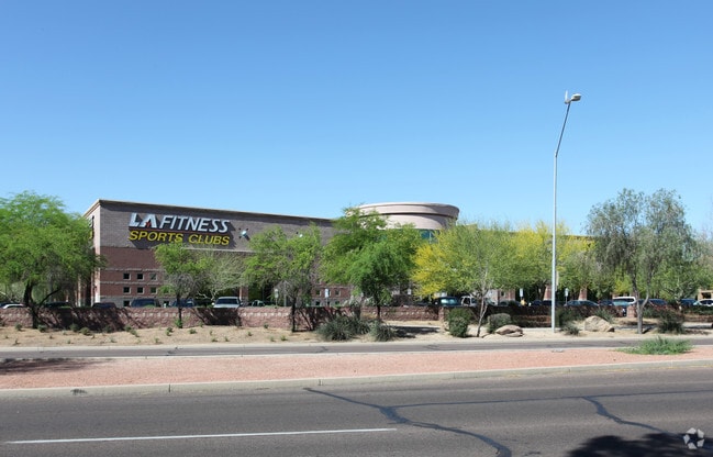
11630 N Tatum Blvd
167-45-180A
STONECREEK CORPORATE CENTER MCR 513-46
Gymhealthspa
Maricopa
I-P
Arizona
C and X Area of minimal flood hazard, usually depicted on FIRMs as above the 500-year flood level.
4c
2025
3.82 AC
2025
Central Scottsdale
103208
Phoenix
34,788 SF
Phoenix-Mesa-Chandler, AZ
NEARBY LISTINGS FOR SALE OR LEASE
DEMOGRAPHICS near 11630 N Tatum Blvd
1 mile
3 mile
5 mile
2025 Total Population
11,944
83,814
223,208
2030 Population
12,491
86,585
232,522
Pop Growth 2025-2030
+ 4.58%
+ 3.31%
+ 4.17%
Average Age
45
43
43
2025 Total Households
5,944
34,185
94,629
HH Growth 2025-2030
+ 5.01%
+ 3.45%
+ 4.42%
Median Household Inc
$83,225
$107,654
$100,324
Avg Household Size
1.90
2.40
2.30
2025 Avg HH Vehicles
2.00
2.00
2.00
Median Home Value
$620,134
$692,549
$671,320
Median Year Built
1985
1980
1985
Nearby Places
Map Layers
Map Styles
 Street
 Aerial
Layers
 Traffic
 Biking
Places
Listings with unknown addresses are not visible on the map
- Restaurants
- Banks
- Shops
- Fitness
- Groceries
PUBLIC TRANSPORTATION
AIRPORT
Phoenix Sky Harbor International
Drive
Walk
Distance
Phoenix Sky Harbor International
26 min
16.1 mi
Phoenix-Mesa Gateway
Drive
Walk
Distance
Phoenix-Mesa Gateway
56 min
38.5 mi
Nearby Properties
Address
Land Use
TOTAL SIZE
Lot Size
Zoning
Address
Land Use
TOTAL SIZE
Lot Size
Zoning
17.81 AC
Address
Land Use
TOTAL SIZE
Lot Size
Zoning
128,046 SF
9.97 AC
C2
Address
Land Use
TOTAL SIZE
Lot Size
Zoning
33,244 SF
5.93 AC
C-2
Address
Land Use
TOTAL SIZE
Lot Size
Zoning
4.67 AC
Address
Land Use
TOTAL SIZE
Lot Size
Zoning
367,367 SF
37.89 AC
R-43
Address
Land Use
TOTAL SIZE
Lot Size
Zoning
9,232 SF
4.07 AC
R-35
Address
Land Use
TOTAL SIZE
Lot Size
Zoning
302,647 SF
27.82 AC
C-1
Address
Land Use
TOTAL SIZE
Lot Size
Zoning
580,563 SF
9 AC
C-T
Address
Land Use
TOTAL SIZE
Lot Size
Zoning
512,499 SF
23.03 AC
R3A
Address
Land Use
TOTAL SIZE
Lot Size
Zoning
323,288 SF
40.56 AC
R1-10
Address
Land Use
TOTAL SIZE
Lot Size
Zoning
730,170 SF
49.68 AC
RSC
Address
Land Use
TOTAL SIZE
Lot Size
Zoning
318,389 SF
37.57 AC
R-14
Address
Land Use
TOTAL SIZE
Lot Size
Zoning
167,532 SF
30 AC
R-14
Address
Land Use
TOTAL SIZE
Lot Size
Zoning
352,440 SF
17.51 AC
R-5
Address
Land Use
TOTAL SIZE
Lot Size
Zoning
1.26 AC
Address
Land Use
TOTAL SIZE
Lot Size
Zoning
162,334 SF
18.85 AC
R-35
Address
Land Use
TOTAL SIZE
Lot Size
Zoning
415,053 SF
6.29 AC
Address
Land Use
TOTAL SIZE
Lot Size
Zoning
168,217 SF
40 AC
R-14
Address
Land Use
TOTAL SIZE
Lot Size
Zoning
245,623 SF
5.09 AC
I-P
Address
Land Use
TOTAL SIZE
Lot Size
Zoning
281,018 SF
9.26 AC
M-H
Address
Land Use
TOTAL SIZE
Lot Size
Zoning
14,734 SF
36.71 AC
R110
Address
Land Use
TOTAL SIZE
Lot Size
Zoning
115,983 SF
4.85 AC
R-14
Address
Land Use
TOTAL SIZE
Lot Size
Zoning
208,370 SF
19.49 AC
Address
Land Use
TOTAL SIZE
Lot Size
Zoning
135,017 SF
10.42 AC
C-R
Address
Land Use
TOTAL SIZE
Lot Size
Zoning
81,692 SF
8.65 AC
R-10
Address
Land Use
TOTAL SIZE
Lot Size
Zoning
180,205 SF
11.53 AC
C-C
Address
Land Use
TOTAL SIZE
Lot Size
Zoning
110,623 SF
4.39 AC
R-10
Address
Land Use
TOTAL SIZE
Lot Size
Zoning
80,300 SF
19.39 AC
PF
Address
Land Use
TOTAL SIZE
Lot Size
Zoning
1.31 AC
Address
Land Use
TOTAL SIZE
Lot Size
Zoning
242,255 SF
7.26 AC
The World's #1 Commercial Real Estate Marketplace
Connect with us
© 2026 CoStar Group
The information above has been obtained from sources believed reliable. While we do not doubt its accuracy we have not verified it and make no guarantee, warranty or representation about it. It is your responsibility to independently confirm its accuracy and completeness. Any projections, opinions, assumptions, or estimates used are for example only and do not represent the current or future performance of the property. The value of this transaction to you depends on tax and other factors which should be evaluated by your tax, financial, and legal advisors. You and your advisors should conduct a careful, independent investigation of the property to determine to your satisfaction the suitability of the property for your needs.