Property Record
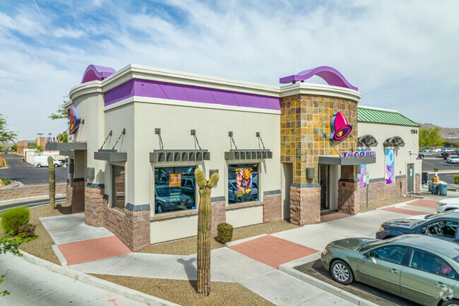
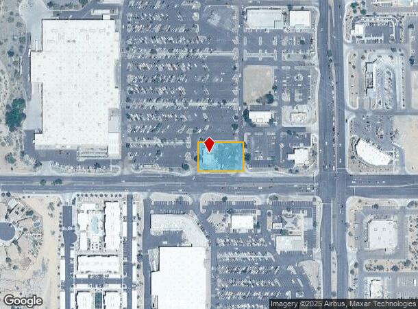
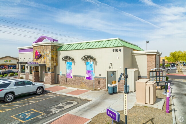
1164 S Watson Rd, Buckeye, AZ 85326

NEARBY LISTINGS FOR SALE OR LEASE
-
-
View all Buckeye listings for sale on LoopNet.com
Property Detail
1164 S Watson Rd
Phoenix-Mesa-Chandler, AZ
Sundance Towne Center
504-19-971
SUNDANCE TOWNE CENTER MCR 800-38
Restaurantdrivein
Maricopa
X
Arizona
04013C2120M
19
2025
0.69 AC
2025
South Buckeye
050615
Phoenix
2,979 SF
DEMOGRAPHICS near 1164 S Watson Rd
1 Mile
3 Mile
5 Mile
2024 Total Population
10,123
39,339
77,671
2029 Population
11,125
43,120
85,256
Pop Growth 2024-2029
+ 9.90%
+ 9.61%
+ 9.77%
Average Age
37
35
35
2024 Total Households
3,202
11,634
23,305
HH Growth 2024-2029
+ 10.06%
+ 9.73%
+ 9.86%
Median Household Inc
$78,892
$81,686
$85,625
Avg Household Size
3.10
3.30
3.30
2024 Avg HH Vehicles
2.00
2.00
2.00
Median Home Value
$288,730
$281,284
$314,372
Median Year Built
2008
2006
2008
Nearby Places
Map Layers
Map Styles
 Street
 Aerial
- Restaurants
- Banks
- Shops
- Fitness
- Groceries
PUBLIC TRANSPORTATION
AIRPORT
Phoenix Sky Harbor International
DRIVE
WALK
Distance
Phoenix Sky Harbor International
45 min
35.1 mi
Nearby Properties
Address
Land Use
TOTAL SIZE
Lot Size
Zoning
Address
Land Use
TOTAL SIZE
Lot Size
Zoning
13.35 AC
Address
Land Use
TOTAL SIZE
Lot Size
Zoning
862,622 SF
75.39 AC
GC
Address
Land Use
TOTAL SIZE
Lot Size
Zoning
11.14 AC
Address
Land Use
TOTAL SIZE
Lot Size
Zoning
18.64 AC
Address
Land Use
TOTAL SIZE
Lot Size
Zoning
269,665 SF
54.66 AC
PC
Address
Land Use
TOTAL SIZE
Lot Size
Zoning
13.06 AC
Address
Land Use
TOTAL SIZE
Lot Size
Zoning
326,103 SF
21.54 AC
Address
Land Use
TOTAL SIZE
Lot Size
Zoning
1.98 AC
PAD
Address
Land Use
TOTAL SIZE
Lot Size
Zoning
217,965 SF
23.03 AC
PAD
Address
Land Use
TOTAL SIZE
Lot Size
Zoning
93,337 SF
15.37 AC
PC
Address
Land Use
TOTAL SIZE
Lot Size
Zoning
78,774 SF
7.57 AC
PUD
Address
Land Use
TOTAL SIZE
Lot Size
Zoning
108,818 SF
10.65 AC
C-C
Address
Land Use
TOTAL SIZE
Lot Size
Zoning
78,165 SF
15.81 AC
PUD
Address
Land Use
TOTAL SIZE
Lot Size
Zoning
858,000 SF
69.08 AC
GC
Address
Land Use
TOTAL SIZE
Lot Size
Zoning
73,130 SF
3.68 AC
PAD
Address
Land Use
TOTAL SIZE
Lot Size
Zoning
138,134 SF
13.14 AC
PAD
Address
Land Use
TOTAL SIZE
Lot Size
Zoning
72,254 SF
13.66 AC
PAD
Address
Land Use
TOTAL SIZE
Lot Size
Zoning
3.34 AC
Address
Land Use
TOTAL SIZE
Lot Size
Zoning
75,026 SF
14.07 AC
PAD
Address
Land Use
TOTAL SIZE
Lot Size
Zoning
57,950 SF
9.89 AC
PAD
Address
Land Use
TOTAL SIZE
Lot Size
Zoning
85,712 SF
15.18 AC
PR
Address
Land Use
TOTAL SIZE
Lot Size
Zoning
102,640 SF
3.73 AC
PC
Address
Land Use
TOTAL SIZE
Lot Size
Zoning
40,104 SF
4.75 AC
PAD
Address
Land Use
TOTAL SIZE
Lot Size
Zoning
3.10 AC
Address
Land Use
TOTAL SIZE
Lot Size
Zoning
55,485 SF
2.10 AC
PC
Address
Land Use
TOTAL SIZE
Lot Size
Zoning
188,937 SF
20.87 AC
Address
Land Use
TOTAL SIZE
Lot Size
Zoning
50,445 SF
2.05 AC
PAD
Address
Land Use
TOTAL SIZE
Lot Size
Zoning
38,620 SF
20.87 AC
C-G
Address
Land Use
TOTAL SIZE
Lot Size
Zoning
48,556 SF
7.68 AC
Address
Land Use
TOTAL SIZE
Lot Size
Zoning
26,239 SF
6.26 AC
RR
The World's #1 Commercial Real Estate Marketplace
Connect with us
© 2026 CoStar Group
The information above has been obtained from sources believed reliable. While we do not doubt its accuracy we have not verified it and make no guarantee, warranty or representation about it. It is your responsibility to independently confirm its accuracy and completeness. Any projections, opinions, assumptions, or estimates used are for example only and do not represent the current or future performance of the property. The value of this transaction to you depends on tax and other factors which should be evaluated by your tax, financial, and legal advisors. You and your advisors should conduct a careful, independent investigation of the property to determine to your satisfaction the suitability of the property for your needs.