Property Record
11640 Harrel St, Jurupa Valley, CA 91752
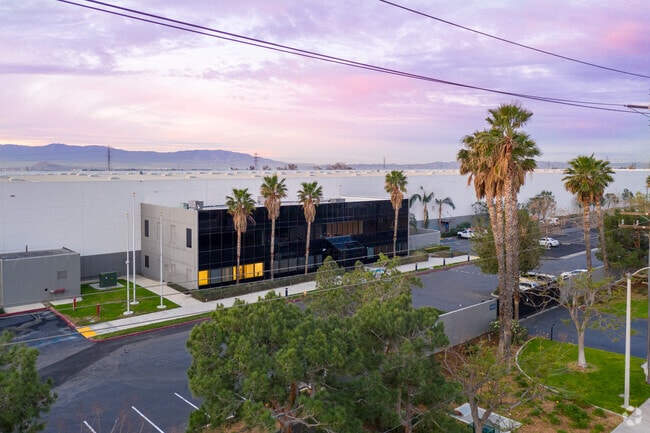


Property Detail
11640 Harrel St
156-340-042
41.72 ACRES M/L IN POR PARS 1 & 2 AND PAR 3 PM 175/010 PM 25317 FOR TOTAL DESCRIPTION SEE ASSESSORS MAPS
Warehouse
Riverside
MSC
California
C and X Area of minimal flood hazard, usually depicted on FIRMs as above the 500-year flood level.
1
2024
41.72 AC
2025
Riverside
040618
Inland Empire (California)
880,000 SF
Riverside-San Bernardino-Ontario, CA
NEARBY LISTINGS FOR SALE OR LEASE
DEMOGRAPHICS near 11640 Harrel St
1 mile
3 mile
5 mile
2025 Total Population
3,491
69,791
188,961
2030 Population
3,562
71,247
192,785
Pop Growth 2025-2030
+ 2.03%
+ 2.09%
+ 2.02%
Average Age
35
37
36
2025 Total Households
977
19,620
51,516
HH Growth 2025-2030
+ 1.74%
+ 1.70%
+ 1.73%
Median Household Inc
$159,432
$114,375
$116,901
Avg Household Size
3.60
3.50
3.60
2025 Avg HH Vehicles
2.00
3.00
3.00
Median Home Value
$748,198
$686,464
$697,852
Median Year Built
2011
1990
1995
Nearby Places
Map Layers
Map Styles
 Street
 Aerial
Layers
 Traffic
 Biking
Places
Listings with unknown addresses are not visible on the map
- Restaurants
- Banks
- Shops
- Fitness
- Groceries
PUBLIC TRANSPORTATION
COMMUTER RAIL
East Ontario (Riverside Line - Southern California Regional Rail Authority (Metrolink))
Drive
Walk
Distance
East Ontario (Riverside Line - Southern California Regional Rail Authority (Metrolink))
9 min
4.3 mi
Pedley (Riverside Line - Southern California Regional Rail Authority (Metrolink))
Drive
Walk
Distance
Pedley (Riverside Line - Southern California Regional Rail Authority (Metrolink))
11 min
5.8 mi
AIRPORT
Ontario International
Drive
Walk
Distance
Ontario International
13 min
7.0 mi
John Wayne/Orange County
Drive
Walk
Distance
John Wayne/Orange County
50 min
38.5 mi
Freight Ports
Port of Long Beach
Drive
Walk
Distance
Port of Long Beach
70 min
54.7 mi
SALE & LEASE HISTORY
LISTING DATE
SALE/LEASE

Jan 07, 2020
For Lease
Nearby Properties
Address
Land Use
TOTAL SIZE
Lot Size
Zoning
Address
Land Use
TOTAL SIZE
Lot Size
Zoning
1,003,458 SF
52.98 AC
Address
Land Use
TOTAL SIZE
Lot Size
Zoning
1,379,287 SF
62.56 AC
Address
Land Use
TOTAL SIZE
Lot Size
Zoning
759,260 SF
42.77 AC
Address
Land Use
TOTAL SIZE
Lot Size
Zoning
760,915 SF
30.34 AC
Address
Land Use
TOTAL SIZE
Lot Size
Zoning
459,431 SF
23.10 AC
Address
Land Use
TOTAL SIZE
Lot Size
Zoning
329,831 SF
15.51 AC
MSC
Address
Land Use
TOTAL SIZE
Lot Size
Zoning
489,989 SF
24.49 AC
Address
Land Use
TOTAL SIZE
Lot Size
Zoning
23.37 AC
Address
Land Use
TOTAL SIZE
Lot Size
Zoning
560,025 SF
25.85 AC
Address
Land Use
TOTAL SIZE
Lot Size
Zoning
210,615 SF
9.42 AC
MM
Address
Land Use
TOTAL SIZE
Lot Size
Zoning
901,662 SF
33.87 AC
IP
Address
Land Use
TOTAL SIZE
Lot Size
Zoning
43.78 AC
Address
Land Use
TOTAL SIZE
Lot Size
Zoning
235,781 SF
10.80 AC
Address
Land Use
TOTAL SIZE
Lot Size
Zoning
317,070 SF
14.26 AC
Address
Land Use
TOTAL SIZE
Lot Size
Zoning
256,308 SF
11.36 AC
Address
Land Use
TOTAL SIZE
Lot Size
Zoning
1,007,705 SF
33.83 AC
Address
Land Use
TOTAL SIZE
Lot Size
Zoning
800,260 SF
37.25 AC
MSC
Address
Land Use
TOTAL SIZE
Lot Size
Zoning
817,493 SF
93.45 AC
Address
Land Use
TOTAL SIZE
Lot Size
Zoning
310,406 SF
13.74 AC
Address
Land Use
TOTAL SIZE
Lot Size
Zoning
235,119 SF
11 AC
Address
Land Use
TOTAL SIZE
Lot Size
Zoning
263,188 SF
12.63 AC
Address
Land Use
TOTAL SIZE
Lot Size
Zoning
923,083 SF
48.34 AC
Address
Land Use
TOTAL SIZE
Lot Size
Zoning
2,107,892 SF
71.83 AC
MSC
Address
Land Use
TOTAL SIZE
Lot Size
Zoning
784,500 SF
44.37 AC
MM
Address
Land Use
TOTAL SIZE
Lot Size
Zoning
645,311 SF
27.33 AC
IP
Address
Land Use
TOTAL SIZE
Lot Size
Zoning
765,456 SF
34.90 AC
IP
Address
Land Use
TOTAL SIZE
Lot Size
Zoning
Address
Land Use
TOTAL SIZE
Lot Size
Zoning
151,805 SF
10.59 AC
CM
Address
Land Use
TOTAL SIZE
Lot Size
Zoning
22,572 SF
17.67 AC
R3
Address
Land Use
TOTAL SIZE
Lot Size
Zoning
28.90 AC
The World's #1 Commercial Real Estate Marketplace
Connect with us
© 2026 CoStar Group
The information above has been obtained from sources believed reliable. While we do not doubt its accuracy we have not verified it and make no guarantee, warranty or representation about it. It is your responsibility to independently confirm its accuracy and completeness. Any projections, opinions, assumptions, or estimates used are for example only and do not represent the current or future performance of the property. The value of this transaction to you depends on tax and other factors which should be evaluated by your tax, financial, and legal advisors. You and your advisors should conduct a careful, independent investigation of the property to determine to your satisfaction the suitability of the property for your needs.