Property Record
11643 Se Loop 410, San Antonio, TX 78221
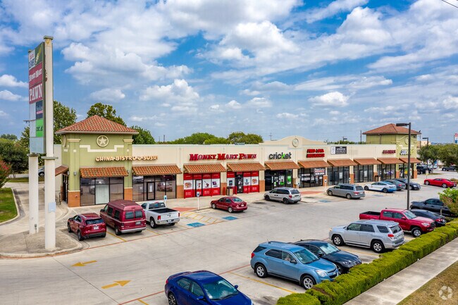

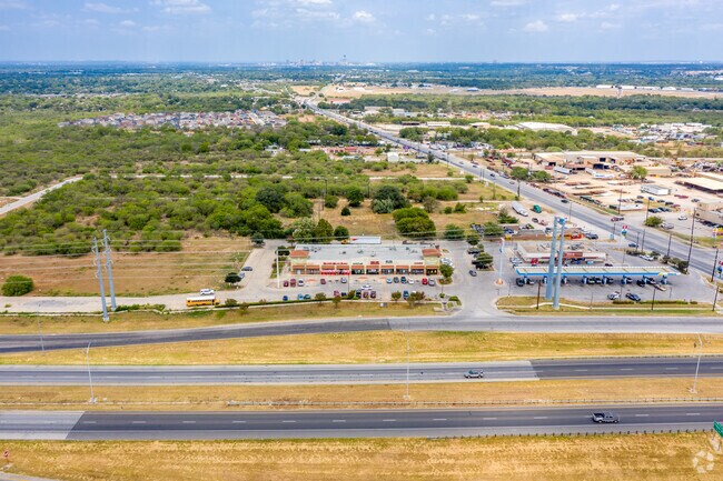
Property Detail
11643 Se Loop 410
San Antonio-New Braunfels, TX
NCB 11156 BLK LOT 13 (ESPADA NORTH-PHASE ONE) PER PLAT 9607/85-88
11156-000-0130
BEXAR
Regionalshoppingcenterormallwithanchorstore
Texas
B and X Area of moderate flood hazard, usually the area between the limits of the 100-year and 500-year floods.
13
2025
2.52 AC
2025
South
151700
San Antonio
14,000 SF
NEARBY LISTINGS FOR SALE OR LEASE
DEMOGRAPHICS near 11643 Se Loop 410
1 mile
3 mile
5 mile
2025 Total Population
5,443
52,138
175,095
2030 Population
5,785
55,311
184,659
Pop Growth 2025-2030
+ 6.28%
+ 6.09%
+ 5.46%
Average Age
37
36
37
2025 Total Households
1,713
17,197
58,799
HH Growth 2025-2030
+ 6.36%
+ 6.13%
+ 5.56%
Median Household Inc
$66,346
$63,924
$54,380
Avg Household Size
3.10
2.90
2.90
2025 Avg HH Vehicles
2.00
2.00
2.00
Median Home Value
$167,628
$177,975
$161,405
Median Year Built
1993
1980
1969
Nearby Places
Map Layers
Map Styles
 Street
 Aerial
Layers
 Traffic
 Biking
Places
Listings with unknown addresses are not visible on the map
- Restaurants
- Banks
- Shops
- Fitness
- Groceries
PUBLIC TRANSPORTATION
COMMUTER RAIL
Drive
Walk
Distance
15 min
7.9 mi
AIRPORT
San Antonio International
Drive
Walk
Distance
San Antonio International
24 min
15.8 mi
SALE & LEASE HISTORY
LISTING DATE
SALE/LEASE

Sep 25, 2016
For Lease
Sep 25, 2016
For Lease
Oct 30, 2018
For Lease
Nearby Properties
Address
Land Use
TOTAL SIZE
Lot Size
Zoning
Address
Land Use
TOTAL SIZE
Lot Size
Zoning
32,800 SF
198.68 AC
Address
Land Use
TOTAL SIZE
Lot Size
Zoning
639,848 SF
85.65 AC
Address
Land Use
TOTAL SIZE
Lot Size
Zoning
220,079 SF
28.12 AC
Address
Land Use
TOTAL SIZE
Lot Size
Zoning
61,085 SF
16.73 AC
Address
Land Use
TOTAL SIZE
Lot Size
Zoning
158,546 SF
6.45 AC
Address
Land Use
TOTAL SIZE
Lot Size
Zoning
12,504,292 SF
32.18 AC
Address
Land Use
TOTAL SIZE
Lot Size
Zoning
353,148 SF
14.10 AC
Address
Land Use
TOTAL SIZE
Lot Size
Zoning
163.70 AC
Address
Land Use
TOTAL SIZE
Lot Size
Zoning
69.76 AC
Address
Land Use
TOTAL SIZE
Lot Size
Zoning
372,078 SF
10.95 AC
Address
Land Use
TOTAL SIZE
Lot Size
Zoning
211,365 SF
11.65 AC
Address
Land Use
TOTAL SIZE
Lot Size
Zoning
71,607 SF
10.46 AC
Address
Land Use
TOTAL SIZE
Lot Size
Zoning
79,740 SF
0.60 AC
Address
Land Use
TOTAL SIZE
Lot Size
Zoning
38,671 SF
5.20 AC
Address
Land Use
TOTAL SIZE
Lot Size
Zoning
Address
Land Use
TOTAL SIZE
Lot Size
Zoning
203,232 SF
24.20 AC
Address
Land Use
TOTAL SIZE
Lot Size
Zoning
244,072 SF
13.97 AC
Address
Land Use
TOTAL SIZE
Lot Size
Zoning
89,949 SF
7.14 AC
Address
Land Use
TOTAL SIZE
Lot Size
Zoning
99,361 SF
9.93 AC
Address
Land Use
TOTAL SIZE
Lot Size
Zoning
154,556 SF
7.52 AC
Address
Land Use
TOTAL SIZE
Lot Size
Zoning
225,994 SF
12.25 AC
Address
Land Use
TOTAL SIZE
Lot Size
Zoning
144,137 SF
10.44 AC
Address
Land Use
TOTAL SIZE
Lot Size
Zoning
261,619 SF
20.15 AC
Address
Land Use
TOTAL SIZE
Lot Size
Zoning
103,669 SF
8.11 AC
Address
Land Use
TOTAL SIZE
Lot Size
Zoning
50,194 SF
6.38 AC
Address
Land Use
TOTAL SIZE
Lot Size
Zoning
120,339 SF
7.28 AC
Address
Land Use
TOTAL SIZE
Lot Size
Zoning
168.41 AC
Address
Land Use
TOTAL SIZE
Lot Size
Zoning
105,280 SF
5.06 AC
Address
Land Use
TOTAL SIZE
Lot Size
Zoning
132,338 SF
2.89 AC
Address
Land Use
TOTAL SIZE
Lot Size
Zoning
124,341 SF
11.48 AC
The World's #1 Commercial Real Estate Marketplace
Connect with us
© 2026 CoStar Group
The information above has been obtained from sources believed reliable. While we do not doubt its accuracy we have not verified it and make no guarantee, warranty or representation about it. It is your responsibility to independently confirm its accuracy and completeness. Any projections, opinions, assumptions, or estimates used are for example only and do not represent the current or future performance of the property. The value of this transaction to you depends on tax and other factors which should be evaluated by your tax, financial, and legal advisors. You and your advisors should conduct a careful, independent investigation of the property to determine to your satisfaction the suitability of the property for your needs.