Property Record
11649 E Highway 25, Ocklawaha, FL 32179
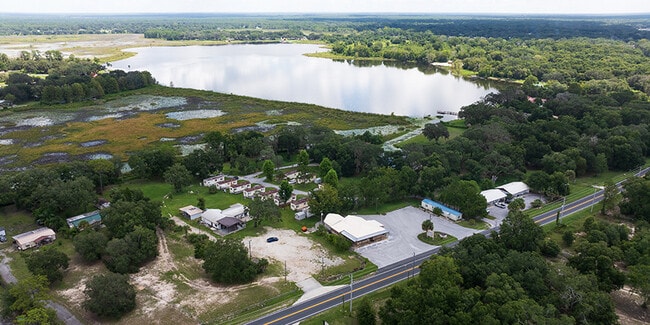
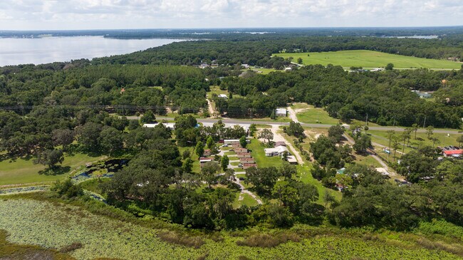
This Property Is For Sale
NEARBY LISTINGS FOR SALE OR LEASE
Property Detail
11649 E Highway 25
Ocala, FL
On The Lake Park
4496-007-000
SEC 01 TWP 17 RGE 23 PLAT BOOK D PAGE 084 LAKEWOOD E 1/2 OF THE FOLLOWING DESC PROPERTY: COM AT THE SE COR LOT 11 TH N 74-17-20 W 20.98 FT TO THE POB TH CONT N 74-17-20 W 167.84 FT TH N 01-54-00 W 321.32 FT TH S 79-13-04 E 163.98 FT TH S 01-54-00 E 3
Mobilemanufacturedhomeregardlessoflandownership
Marion
A
Florida
12083C0765D
11
2024
5.03 AC
2024
Eastern Marion County
0007013087
Ocala
17,375 SF
DEMOGRAPHICS near 11649 E Highway 25
1 Mile
3 Mile
5 Mile
2024 Total Population
1,248
14,453
38,253
2029 Population
1,415
16,351
43,491
Pop Growth 2024-2029
+ 13.38%
+ 13.13%
+ 13.69%
Average Age
40
51
49
2024 Total Households
478
6,461
16,755
HH Growth 2024-2029
+ 13.18%
+ 12.88%
+ 13.51%
Median Household Inc
$50,533
$56,029
$57,759
Avg Household Size
2.50
2.20
2.30
2024 Avg HH Vehicles
2.00
2.00
2.00
Median Home Value
$158,510
$221,239
$203,615
Median Year Built
1989
1999
1997
Nearby Places
- Restaurants
- Banks
- Shops
- Fitness
- Groceries
Nearby Properties
Address
Land Use
TOTAL SIZE
Lot Size
Zoning
Address
Land Use
TOTAL SIZE
Lot Size
Zoning
10,679 SF
601.36 AC
GU
Address
Land Use
TOTAL SIZE
Lot Size
Zoning
246,762 SF
55.08 AC
PUD
Address
Land Use
TOTAL SIZE
Lot Size
Zoning
28,075 SF
6.92 AC
PUD
Address
Land Use
TOTAL SIZE
Lot Size
Zoning
130,596 SF
12.49 AC
M2
Address
Land Use
TOTAL SIZE
Lot Size
Zoning
23,195 SF
372.11 AC
PUD
Address
Land Use
TOTAL SIZE
Lot Size
Zoning
712.83 AC
A1
Address
Land Use
TOTAL SIZE
Lot Size
Zoning
42,685 SF
9.08 AC
B4
Address
Land Use
TOTAL SIZE
Lot Size
Zoning
53,142 SF
8.97 AC
M2
Address
Land Use
TOTAL SIZE
Lot Size
Zoning
23,659 SF
15.47 AC
A1
Address
Land Use
TOTAL SIZE
Lot Size
Zoning
42,220 SF
6.90 AC
B5
Address
Land Use
TOTAL SIZE
Lot Size
Zoning
808.82 AC
A1
Address
Land Use
TOTAL SIZE
Lot Size
Zoning
16,105 SF
32.19 AC
PUD
Address
Land Use
TOTAL SIZE
Lot Size
Zoning
65,538 SF
9.28 AC
M2
Address
Land Use
TOTAL SIZE
Lot Size
Zoning
34,578 SF
19.63 AC
B2
Address
Land Use
TOTAL SIZE
Lot Size
Zoning
1,802 SF
1.74 AC
PUD
Address
Land Use
TOTAL SIZE
Lot Size
Zoning
2.47 AC
R3
Address
Land Use
TOTAL SIZE
Lot Size
Zoning
9,230 SF
2.16 AC
B2
Address
Land Use
TOTAL SIZE
Lot Size
Zoning
625 SF
5.10 AC
GU
Address
Land Use
TOTAL SIZE
Lot Size
Zoning
7,703 SF
2.29 AC
B2
Address
Land Use
TOTAL SIZE
Lot Size
Zoning
18,243 SF
7.71 AC
B4
Address
Land Use
TOTAL SIZE
Lot Size
Zoning
30,750 SF
10 AC
M1
Address
Land Use
TOTAL SIZE
Lot Size
Zoning
9,086 SF
1.63 AC
B2
Address
Land Use
TOTAL SIZE
Lot Size
Zoning
15,919 SF
3.55 AC
R3
Address
Land Use
TOTAL SIZE
Lot Size
Zoning
8,976 SF
4 AC
A1
Address
Land Use
TOTAL SIZE
Lot Size
Zoning
12,592 SF
4.82 AC
B2
Address
Land Use
TOTAL SIZE
Lot Size
Zoning
4,504 SF
18.95 AC
A1
Address
Land Use
TOTAL SIZE
Lot Size
Zoning
8,320 SF
1.14 AC
B2
Address
Land Use
TOTAL SIZE
Lot Size
Zoning
5,150 SF
6.20 AC
GU
Address
Land Use
TOTAL SIZE
Lot Size
Zoning
1,854 SF
3.20 AC
A1
Address
Land Use
TOTAL SIZE
Lot Size
Zoning
968 SF
0.62 AC
R3
The World's #1 Commercial Real Estate Marketplace
Connect with us
© 2025 CoStar Group
The information above has been obtained from sources believed reliable. While we do not doubt its accuracy we have not verified it and make no guarantee, warranty or representation about it. It is your responsibility to independently confirm its accuracy and completeness. Any projections, opinions, assumptions, or estimates used are for example only and do not represent the current or future performance of the property. The value of this transaction to you depends on tax and other factors which should be evaluated by your tax, financial, and legal advisors. You and your advisors should conduct a careful, independent investigation of the property to determine to your satisfaction the suitability of the property for your needs.