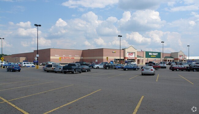
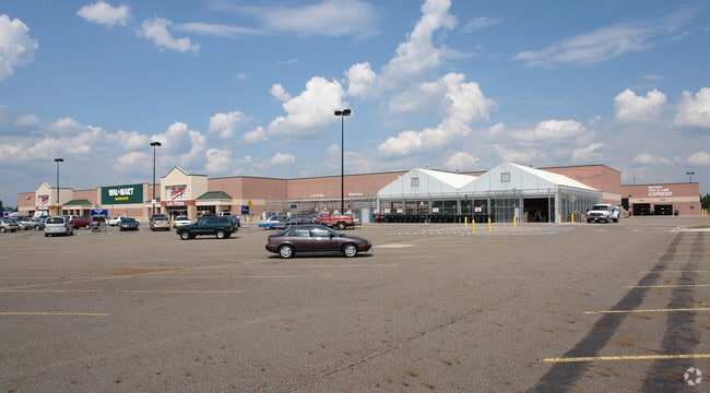
Property Record
1165 Superior Dr, Saint Johns, MI 48879
Property Detail
1165 Superior Dr
030-022-200-077-50
BEG E 463.59 FT FROM W 1/4 COR SEC22 T7N R2W, TH N 213.47 FT, E 848 FT, S 1059.6 FT, TH ON 500 FT RAD CURVE RIGHT ARC LENGTH
Wholesaleoutletdiscountstore
Clinton
C-2
Michigan
B and X Area of moderate flood hazard, usually the area between the limits of the 100-year and 500-year floods.
18.57 AC
2025
Outlying Clinton County
2026
West Michigan
010901
Lansing-East Lansing, MI
190,942 SF
NEARBY LISTINGS FOR SALE OR LEASE
DEMOGRAPHICS near 1165 Superior Dr
1 mile
3 mile
5 mile
2025 Total Population
1,445
10,387
12,874
2030 Population
1,453
10,452
12,981
Pop Growth 2025-2030
+ 0.55%
+ 0.63%
+ 0.83%
Average Age
43
42
43
2025 Total Households
589
4,299
5,229
HH Growth 2025-2030
+ 0.68%
+ 0.67%
+ 0.88%
Median Household Inc
$117,452
$82,552
$86,809
Avg Household Size
2.30
2.30
2.40
2025 Avg HH Vehicles
2.00
2.00
2.00
Median Home Value
$287,867
$208,215
$225,568
Median Year Built
1987
1970
1971
Nearby Places
Map Layers
Map Styles
 Street
 Aerial
Layers
 Traffic
 Biking
Places
Listings with unknown addresses are not visible on the map
- Restaurants
- Banks
- Shops
- Fitness
- Groceries
PUBLIC TRANSPORTATION
AIRPORT
Capital Region International
Drive
Walk
Distance
Capital Region International
29 min
18.6 mi
Freight Ports
Port of Toledo
Drive
Walk
Distance
Port of Toledo
164 min
131.4 mi
Nearby Properties
Address
Land Use
TOTAL SIZE
Lot Size
Zoning
Address
Land Use
TOTAL SIZE
Lot Size
Zoning
375,000 SF
Address
Land Use
TOTAL SIZE
Lot Size
Zoning
106,182 SF
65 AC
Address
Land Use
TOTAL SIZE
Lot Size
Zoning
46,540 SF
13.77 AC
RO
Address
Land Use
TOTAL SIZE
Lot Size
Zoning
232,479 SF
16.85 AC
I-2
Address
Land Use
TOTAL SIZE
Lot Size
Zoning
164,233 SF
14.07 AC
I-1
Address
Land Use
TOTAL SIZE
Lot Size
Zoning
84.91 AC
AGR
Address
Land Use
TOTAL SIZE
Lot Size
Zoning
79,006 SF
31.12 AC
R3
Address
Land Use
TOTAL SIZE
Lot Size
Zoning
136,214 SF
8.13 AC
R3
Address
Land Use
TOTAL SIZE
Lot Size
Zoning
72,495 SF
22.62 AC
MC
Address
Land Use
TOTAL SIZE
Lot Size
Zoning
70,510 SF
9.40 AC
C-2
Address
Land Use
TOTAL SIZE
Lot Size
Zoning
22,740 SF
4.13 AC
GC
Address
Land Use
TOTAL SIZE
Lot Size
Zoning
145,547 SF
11.25 AC
GC
Address
Land Use
TOTAL SIZE
Lot Size
Zoning
68,576 SF
7.09 AC
R3
Address
Land Use
TOTAL SIZE
Lot Size
Zoning
43,009 SF
14.76 AC
GC
Address
Land Use
TOTAL SIZE
Lot Size
Zoning
10,884 SF
10.25 AC
C-2
Address
Land Use
TOTAL SIZE
Lot Size
Zoning
51,312 SF
5.60 AC
GC
Address
Land Use
TOTAL SIZE
Lot Size
Zoning
34,423 SF
2.92 AC
O
Address
Land Use
TOTAL SIZE
Lot Size
Zoning
1,960 SF
104.05 AC
MH
Address
Land Use
TOTAL SIZE
Lot Size
Zoning
51,206 SF
2.77 AC
R3
Address
Land Use
TOTAL SIZE
Lot Size
Zoning
45,120 SF
3.21 AC
R3
Address
Land Use
TOTAL SIZE
Lot Size
Zoning
35,616 SF
3.59 AC
R3
Address
Land Use
TOTAL SIZE
Lot Size
Zoning
54,154 SF
4.28 AC
I-1
Address
Land Use
TOTAL SIZE
Lot Size
Zoning
40,416 SF
3.42 AC
R3
Address
Land Use
TOTAL SIZE
Lot Size
Zoning
86,244 SF
15.03 AC
C-2
Address
Land Use
TOTAL SIZE
Lot Size
Zoning
8,897 SF
2.89 AC
GC
Address
Land Use
TOTAL SIZE
Lot Size
Zoning
14,340 SF
15.81 AC
GC
Address
Land Use
TOTAL SIZE
Lot Size
Zoning
19,320 SF
3.64 AC
C-2
Address
Land Use
TOTAL SIZE
Lot Size
Zoning
14,723 SF
2.04 AC
GC
Address
Land Use
TOTAL SIZE
Lot Size
Zoning
264,913 SF
10.88 AC
I-2
The World's #1 Commercial Real Estate Marketplace
Connect with us
© 2026 CoStar Group
The information above has been obtained from sources believed reliable. While we do not doubt its accuracy we have not verified it and make no guarantee, warranty or representation about it. It is your responsibility to independently confirm its accuracy and completeness. Any projections, opinions, assumptions, or estimates used are for example only and do not represent the current or future performance of the property. The value of this transaction to you depends on tax and other factors which should be evaluated by your tax, financial, and legal advisors. You and your advisors should conduct a careful, independent investigation of the property to determine to your satisfaction the suitability of the property for your needs.