Property Record
1165 W 149Th St, Olathe, KS 66061
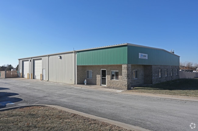

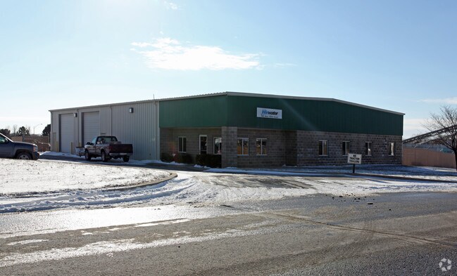
Property Detail
1165 W 149Th St
DP41300000-0014
LONE ELM INDUSTRIAL PARK LT 14& LT 13 EX W 50 OLC 402 14
Warehouse
Johnson
M-3
Kansas
B and X Area of moderate flood hazard, usually the area between the limits of the 100-year and 500-year floods.
14,13
2024
2 AC
2025
Olathe
053603
Kansas City
7,312 SF
Kansas City, MO-KS
NEARBY LISTINGS FOR SALE OR LEASE
DEMOGRAPHICS near 1165 W 149Th St
1 mile
3 mile
5 mile
2025 Total Population
2,527
54,213
134,669
2030 Population
2,620
55,766
139,132
Pop Growth 2025-2030
+ 3.68%
+ 2.86%
+ 3.31%
Average Age
44
37
38
2025 Total Households
916
18,694
46,632
HH Growth 2025-2030
+ 4.15%
+ 3.05%
+ 3.47%
Median Household Inc
$58,957
$95,409
$108,479
Avg Household Size
2.50
2.70
2.80
2025 Avg HH Vehicles
2.00
2.00
2.00
Median Home Value
$277,819
$320,697
$348,697
Median Year Built
1976
1985
1993
Nearby Places
Map Layers
Map Styles
 Street
 Aerial
Transit
 Traffic
 Biking
Places
Listings with unknown addresses are not visible on the map
- Restaurants
- Banks
- Shops
- Fitness
- Groceries
Nearby Properties
Address
Land Use
TOTAL SIZE
Lot Size
Zoning
Address
Land Use
TOTAL SIZE
Lot Size
Zoning
401,604 SF
28.35 AC
CP-O
Address
Land Use
TOTAL SIZE
Lot Size
Zoning
356,910 SF
50.52 AC
RP-4
Address
Land Use
TOTAL SIZE
Lot Size
Zoning
307,761 SF
6.59 AC
C-2
Address
Land Use
TOTAL SIZE
Lot Size
Zoning
512,643 SF
75.55 AC
AG
Address
Land Use
TOTAL SIZE
Lot Size
Zoning
97,340 SF
1.82 AC
C-2
Address
Land Use
TOTAL SIZE
Lot Size
Zoning
456,742 SF
27.31 AC
R-1
Address
Land Use
TOTAL SIZE
Lot Size
Zoning
720,320 SF
39.19 AC
MP-2
Address
Land Use
TOTAL SIZE
Lot Size
Zoning
746,120 SF
PEC3
Address
Land Use
TOTAL SIZE
Lot Size
Zoning
130,576 SF
15.20 AC
RP-4
Address
Land Use
TOTAL SIZE
Lot Size
Zoning
569,960 SF
26.86 AC
M-2
Address
Land Use
TOTAL SIZE
Lot Size
Zoning
565,272 SF
24.79 AC
RUR
Address
Land Use
TOTAL SIZE
Lot Size
Zoning
66,664 SF
2.94 AC
C-2
Address
Land Use
TOTAL SIZE
Lot Size
Zoning
508,664 SF
29.46 AC
MP-2
Address
Land Use
TOTAL SIZE
Lot Size
Zoning
320,835 SF
57.95 AC
M-2
Address
Land Use
TOTAL SIZE
Lot Size
Zoning
499,084 SF
28.99 AC
RUR
Address
Land Use
TOTAL SIZE
Lot Size
Zoning
934,502 SF
34.09 AC
BP
Address
Land Use
TOTAL SIZE
Lot Size
Zoning
177,274 SF
2.69 AC
C-2
Address
Land Use
TOTAL SIZE
Lot Size
Zoning
146,401 SF
7.68 AC
C-1
Address
Land Use
TOTAL SIZE
Lot Size
Zoning
251,981 SF
10.79 AC
R-5
Address
Land Use
TOTAL SIZE
Lot Size
Zoning
129,325 SF
4.50 AC
R-1
Address
Land Use
TOTAL SIZE
Lot Size
Zoning
236,108 SF
12.38 AC
R-1
Address
Land Use
TOTAL SIZE
Lot Size
Zoning
188,944 SF
31.48 AC
R-1
Address
Land Use
TOTAL SIZE
Lot Size
Zoning
44,486 SF
2.70 AC
C-2
Address
Land Use
TOTAL SIZE
Lot Size
Zoning
228,577 SF
17.11 AC
M-2
Address
Land Use
TOTAL SIZE
Lot Size
Zoning
44,486 SF
3.05 AC
C-2
Address
Land Use
TOTAL SIZE
Lot Size
Zoning
331,712 SF
PEC3
Address
Land Use
TOTAL SIZE
Lot Size
Zoning
75,560 SF
32.62 AC
CTY RUR
Address
Land Use
TOTAL SIZE
Lot Size
Zoning
320,891 SF
39.07 AC
M-2
Address
Land Use
TOTAL SIZE
Lot Size
Zoning
244,992 SF
15.75 AC
MP-2
Address
Land Use
TOTAL SIZE
Lot Size
Zoning
45,125 SF
2.83 AC
R-2
The World's #1 Commercial Real Estate Marketplace
Connect with us
© 2026 CoStar Group
The information above has been obtained from sources believed reliable. While we do not doubt its accuracy we have not verified it and make no guarantee, warranty or representation about it. It is your responsibility to independently confirm its accuracy and completeness. Any projections, opinions, assumptions, or estimates used are for example only and do not represent the current or future performance of the property. The value of this transaction to you depends on tax and other factors which should be evaluated by your tax, financial, and legal advisors. You and your advisors should conduct a careful, independent investigation of the property to determine to your satisfaction the suitability of the property for your needs.