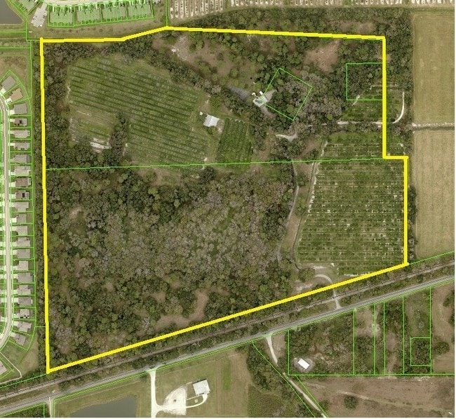
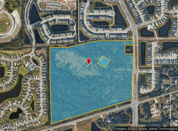
Property Record
11650 Erie Rd, Parrish, FL 34219
NEARBY LISTINGS FOR SALE OR LEASE
Property Detail
11650 Erie Rd
North Port-Sarasota-Bradenton, FL
Manatee River Farms Unit 1
4653-0020-9
BEG AT THE NW COR OF THE NE 1/4 OF SEC 30, TWN 33S, RNG 19E, MANATEE COUNTY, FL; TH S 1 DEG 26 MIN 45 SEC E, ALG THE W LN OF SD NE 1/4, A DIST OF 1173.51 FT TO ITS INT WITH THE N R/W
Publicschool
Manatee
A
Florida
12081C0179E
1
0
71.87 AC
2025
Manatee
001916
Tampa/St Petersburg
DEMOGRAPHICS near 11650 Erie Rd
1 Mile
3 Mile
5 Mile
2024 Total Population
2,415
19,506
51,347
2029 Population
2,829
22,936
60,494
Pop Growth 2024-2029
+ 17.14%
+ 17.58%
+ 17.81%
Average Age
36
43
46
2024 Total Households
814
7,113
20,168
HH Growth 2024-2029
+ 16.22%
+ 16.58%
+ 16.88%
Median Household Inc
$125,744
$103,806
$86,710
Avg Household Size
2.90
2.60
2.50
2024 Avg HH Vehicles
2.00
2.00
2.00
Median Home Value
$298,557
$317,864
$306,868
Median Year Built
2011
2008
2006
Nearby Places
Map Layers
Map Styles
 Street
 Aerial
- Restaurants
- Banks
- Shops
- Fitness
- Groceries
PUBLIC TRANSPORTATION
AIRPORT
Sarasota/Bradenton International
DRIVE
WALK
Distance
Sarasota/Bradenton International
38 min
22.2 mi
St Pete-Clearwater International
DRIVE
WALK
Distance
St Pete-Clearwater International
56 min
38.7 mi
Tampa International
DRIVE
WALK
Distance
Tampa International
62 min
48.2 mi
Freight Ports
Port Manatee
DRIVE
WALK
Distance
Port Manatee
19 min
9.8 mi
SALE & LEASE HISTORY
LISTING DATE
SALE/LEASE

Sep 24, 2016
For Sale
Nearby Properties
Address
Land Use
TOTAL SIZE
Lot Size
Zoning
Address
Land Use
TOTAL SIZE
Lot Size
Zoning
137.34 AC
Address
Land Use
TOTAL SIZE
Lot Size
Zoning
165.96 AC
Address
Land Use
TOTAL SIZE
Lot Size
Zoning
96.72 AC
Address
Land Use
TOTAL SIZE
Lot Size
Zoning
47.43 AC
Address
Land Use
TOTAL SIZE
Lot Size
Zoning
221.01 AC
Address
Land Use
TOTAL SIZE
Lot Size
Zoning
Address
Land Use
TOTAL SIZE
Lot Size
Zoning
120.20 AC
Address
Land Use
TOTAL SIZE
Lot Size
Zoning
50.26 AC
Address
Land Use
TOTAL SIZE
Lot Size
Zoning
64,800 SF
8.19 AC
Address
Land Use
TOTAL SIZE
Lot Size
Zoning
19,260 SF
140.65 AC
A GENERAL
Address
Land Use
TOTAL SIZE
Lot Size
Zoning
58,569 SF
19.67 AC
A GENERAL
Address
Land Use
TOTAL SIZE
Lot Size
Zoning
66,063 SF
9.24 AC
PD-C
Address
Land Use
TOTAL SIZE
Lot Size
Zoning
158.58 AC
Address
Land Use
TOTAL SIZE
Lot Size
Zoning
43,464 SF
14.47 AC
VIL VILLAG
Address
Land Use
TOTAL SIZE
Lot Size
Zoning
43.81 AC
Address
Land Use
TOTAL SIZE
Lot Size
Zoning
50,580 SF
5.97 AC
Address
Land Use
TOTAL SIZE
Lot Size
Zoning
22.88 AC
Address
Land Use
TOTAL SIZE
Lot Size
Zoning
53,851 SF
6.32 AC
Address
Land Use
TOTAL SIZE
Lot Size
Zoning
30,101 SF
13.44 AC
PD-C
Address
Land Use
TOTAL SIZE
Lot Size
Zoning
76.98 AC
Address
Land Use
TOTAL SIZE
Lot Size
Zoning
23,742 SF
5.21 AC
A-1 SUBURB
Address
Land Use
TOTAL SIZE
Lot Size
Zoning
36,700 SF
17 AC
A-1 SUBURB
Address
Land Use
TOTAL SIZE
Lot Size
Zoning
44,874 SF
394.53 AC
PD-PI
Address
Land Use
TOTAL SIZE
Lot Size
Zoning
109.06 AC
Address
Land Use
TOTAL SIZE
Lot Size
Zoning
3.11 AC
Address
Land Use
TOTAL SIZE
Lot Size
Zoning
53,448 SF
3 AC
PD-C
Address
Land Use
TOTAL SIZE
Lot Size
Zoning
86.71 AC
Address
Land Use
TOTAL SIZE
Lot Size
Zoning
Address
Land Use
TOTAL SIZE
Lot Size
Zoning
27.01 AC
Address
Land Use
TOTAL SIZE
Lot Size
Zoning
25,842 SF
3.92 AC
The World's #1 Commercial Real Estate Marketplace
Connect with us
© 2025 CoStar Group
The information above has been obtained from sources believed reliable. While we do not doubt its accuracy we have not verified it and make no guarantee, warranty or representation about it. It is your responsibility to independently confirm its accuracy and completeness. Any projections, opinions, assumptions, or estimates used are for example only and do not represent the current or future performance of the property. The value of this transaction to you depends on tax and other factors which should be evaluated by your tax, financial, and legal advisors. You and your advisors should conduct a careful, independent investigation of the property to determine to your satisfaction the suitability of the property for your needs.