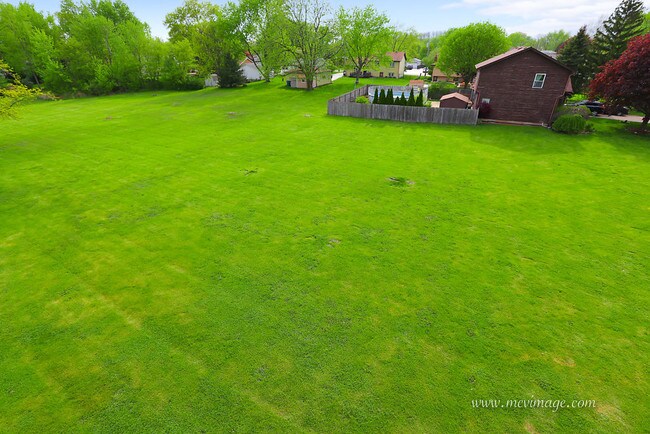
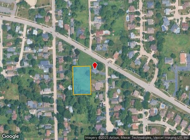
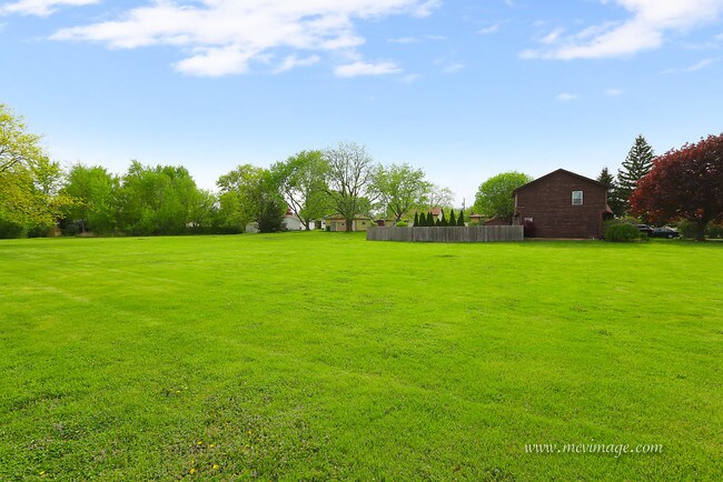
Property Record
1166 Mccarthy Rd, Lemont, IL 60439
NEARBY LISTINGS FOR SALE OR LEASE
Property Detail
1166 Mccarthy Rd
22-28-105-033-0000
Gust Lindgrens Resubdivision
Vacantlandnec
Cook
X
Illinois
17043C0286J
1.01 AC
2023
Joliet/Central Will
2025
Chicago
824003
Chicago-Naperville-Elgin, IL-IN
DEMOGRAPHICS near 1166 Mccarthy Rd
1 Mile
3 Mile
5 Mile
2024 Total Population
9,684
25,922
86,590
2029 Population
9,374
25,198
84,989
Pop Growth 2024-2029
(3.20%)
(2.79%)
(1.85%)
Average Age
45
43
42
2024 Total Households
3,663
9,375
31,200
HH Growth 2024-2029
(3.60%)
(3.07%)
(1.96%)
Median Household Inc
$100,216
$117,840
$100,436
Avg Household Size
2.50
2.70
2.70
2024 Avg HH Vehicles
2.00
2.00
2.00
Median Home Value
$376,678
$408,289
$357,896
Median Year Built
1988
1990
1985
Nearby Places
Map Layers
Map Styles
 Street
 Aerial
- Restaurants
- Banks
- Shops
- Fitness
- Groceries
PUBLIC TRANSPORTATION
COMMUTER RAIL
Lemont Station (Heritage Corridor Line - Northeast Illinois Regional Commuter Railroad (Metra))
DRIVE
WALK
Distance
Lemont Station (Heritage Corridor Line - Northeast Illinois Regional Commuter Railroad (Metra))
2 min
1.3 mi
Romeoville (Heritage Corridor - Metra)
DRIVE
WALK
Distance
Romeoville (Heritage Corridor - Metra)
11 min
5.6 mi
AIRPORT
Chicago Midway International
DRIVE
WALK
Distance
Chicago Midway International
27 min
18.7 mi
Chicago O'Hare International
DRIVE
WALK
Distance
Chicago O'Hare International
44 min
30.1 mi
Freight Ports
Port Milwaukee
DRIVE
WALK
Distance
Port Milwaukee
126 min
101.8 mi
SALE & LEASE HISTORY
LISTING DATE
SALE/LEASE

Aug 09, 2019
For Sale
Nearby Properties
Address
Land Use
TOTAL SIZE
Lot Size
Zoning
Address
Land Use
TOTAL SIZE
Lot Size
Zoning
264,310 SF
12.21 AC
I
Address
Land Use
TOTAL SIZE
Lot Size
Zoning
18.82 AC
Address
Land Use
TOTAL SIZE
Lot Size
Zoning
351,257 SF
16.39 AC
I
Address
Land Use
TOTAL SIZE
Lot Size
Zoning
263,010 SF
13.56 AC
I
Address
Land Use
TOTAL SIZE
Lot Size
Zoning
74,782 SF
5.15 AC
Address
Land Use
TOTAL SIZE
Lot Size
Zoning
119,270 SF
7 AC
I
Address
Land Use
TOTAL SIZE
Lot Size
Zoning
248,971 SF
10.94 AC
I
Address
Land Use
TOTAL SIZE
Lot Size
Zoning
253,622 SF
13.09 AC
Address
Land Use
TOTAL SIZE
Lot Size
Zoning
148,234 SF
7.13 AC
I
Address
Land Use
TOTAL SIZE
Lot Size
Zoning
149,924 SF
8.53 AC
I
Address
Land Use
TOTAL SIZE
Lot Size
Zoning
153,050 SF
8.95 AC
Address
Land Use
TOTAL SIZE
Lot Size
Zoning
165,524 SF
9.36 AC
I
Address
Land Use
TOTAL SIZE
Lot Size
Zoning
180,022 SF
9.49 AC
Address
Land Use
TOTAL SIZE
Lot Size
Zoning
14,972 SF
2.91 AC
C
Address
Land Use
TOTAL SIZE
Lot Size
Zoning
24.85 AC
Address
Land Use
TOTAL SIZE
Lot Size
Zoning
308,882 SF
13.68 AC
I
Address
Land Use
TOTAL SIZE
Lot Size
Zoning
158,700 SF
9 AC
I
Address
Land Use
TOTAL SIZE
Lot Size
Zoning
197,558 SF
15.36 AC
I
Address
Land Use
TOTAL SIZE
Lot Size
Zoning
158,868 SF
8.72 AC
N
Address
Land Use
TOTAL SIZE
Lot Size
Zoning
97,816 SF
10.04 AC
I
Address
Land Use
TOTAL SIZE
Lot Size
Zoning
9.59 AC
Address
Land Use
TOTAL SIZE
Lot Size
Zoning
89,686 SF
5.50 AC
Address
Land Use
TOTAL SIZE
Lot Size
Zoning
152,079 SF
9.68 AC
Address
Land Use
TOTAL SIZE
Lot Size
Zoning
70,848 SF
8.40 AC
Address
Land Use
TOTAL SIZE
Lot Size
Zoning
84,960 SF
7.33 AC
C
Address
Land Use
TOTAL SIZE
Lot Size
Zoning
81,420 SF
5.12 AC
C
Address
Land Use
TOTAL SIZE
Lot Size
Zoning
154,000 SF
9.33 AC
C
Address
Land Use
TOTAL SIZE
Lot Size
Zoning
101,576 SF
5.72 AC
Address
Land Use
TOTAL SIZE
Lot Size
Zoning
15.21 AC
Address
Land Use
TOTAL SIZE
Lot Size
Zoning
53,224 SF
4.84 AC
I
The World's #1 Commercial Real Estate Marketplace
Connect with us
© 2026 CoStar Group
The information above has been obtained from sources believed reliable. While we do not doubt its accuracy we have not verified it and make no guarantee, warranty or representation about it. It is your responsibility to independently confirm its accuracy and completeness. Any projections, opinions, assumptions, or estimates used are for example only and do not represent the current or future performance of the property. The value of this transaction to you depends on tax and other factors which should be evaluated by your tax, financial, and legal advisors. You and your advisors should conduct a careful, independent investigation of the property to determine to your satisfaction the suitability of the property for your needs.