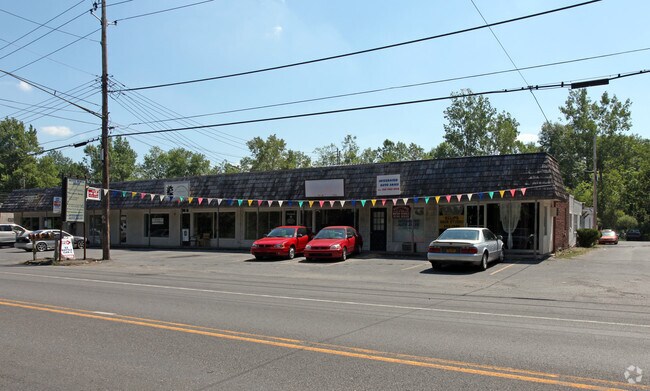
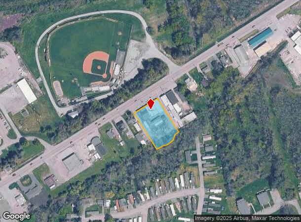
Property Record
1167 E Union St, Newark, NY 14513
NEARBY LISTINGS FOR SALE OR LEASE
Property Detail
1167 E Union St
Rochester, NY
36111-20-932053
542001-068-111-0020-954-049-0000
Wayne
Commercialofficeresidentialmixeduse
New York
2025
954.049
2024
0.91 AC
021200
Wayne County
21,312 SF
Rochester
DEMOGRAPHICS near 1167 E Union St
1 Mile
3 Mile
5 Mile
2024 Total Population
2,691
11,736
18,939
2029 Population
2,668
11,598
18,718
Pop Growth 2024-2029
(0.85%)
(1.18%)
(1.17%)
Average Age
41
43
43
2024 Total Households
1,180
5,005
7,936
HH Growth 2024-2029
(0.93%)
(1.30%)
(1.27%)
Median Household Inc
$55,952
$55,518
$58,015
Avg Household Size
2.10
2.20
2.30
2024 Avg HH Vehicles
2.00
2.00
2.00
Median Home Value
$77,456
$111,947
$110,070
Median Year Built
1949
1956
1952
Nearby Places
- Restaurants
- Banks
- Shops
- Fitness
- Groceries
PUBLIC TRANSPORTATION
AIRPORT
Frederick Douglass/Greater Rochester International
DRIVE
WALK
Distance
Frederick Douglass/Greater Rochester International
50 min
34.6 mi
SALE & LEASE HISTORY
LISTING DATE
SALE/LEASE

Dec 07, 2023
For Sale
Nearby Properties
Address
Land Use
TOTAL SIZE
Lot Size
Zoning
Address
Land Use
TOTAL SIZE
Lot Size
Zoning
89,825 SF
134.02 AC
Address
Land Use
TOTAL SIZE
Lot Size
Zoning
200,670 SF
23.13 AC
B1
Address
Land Use
TOTAL SIZE
Lot Size
Zoning
205,485 SF
35.22 AC
PD
Address
Land Use
TOTAL SIZE
Lot Size
Zoning
153,072 SF
33.68 AC
PID
Address
Land Use
TOTAL SIZE
Lot Size
Zoning
53,312 SF
44.89 AC
PD
Address
Land Use
TOTAL SIZE
Lot Size
Zoning
152,676 SF
27.02 AC
B3
Address
Land Use
TOTAL SIZE
Lot Size
Zoning
39,000 SF
21.49 AC
B3
Address
Land Use
TOTAL SIZE
Lot Size
Zoning
141,523 SF
19.12 AC
PD
Address
Land Use
TOTAL SIZE
Lot Size
Zoning
128,734 SF
16.07 AC
PD
Address
Land Use
TOTAL SIZE
Lot Size
Zoning
65,080 SF
45.77 AC
PD
Address
Land Use
TOTAL SIZE
Lot Size
Zoning
1,600 SF
31.69 AC
R2
Address
Land Use
TOTAL SIZE
Lot Size
Zoning
82,148 SF
13.58 AC
PID
Address
Land Use
TOTAL SIZE
Lot Size
Zoning
15,036 SF
5.26 AC
PD
Address
Land Use
TOTAL SIZE
Lot Size
Zoning
34,909 SF
8.09 AC
R2
Address
Land Use
TOTAL SIZE
Lot Size
Zoning
2,000 SF
52.80 AC
AG
Address
Land Use
TOTAL SIZE
Lot Size
Zoning
1,684 SF
19.70 AC
R1
Address
Land Use
TOTAL SIZE
Lot Size
Zoning
80,000 SF
8.09 AC
Address
Land Use
TOTAL SIZE
Lot Size
Zoning
14,830 SF
3.45 AC
B3
Address
Land Use
TOTAL SIZE
Lot Size
Zoning
13,309 SF
0.94 AC
B2
Address
Land Use
TOTAL SIZE
Lot Size
Zoning
96,496 SF
7.13 AC
B3
Address
Land Use
TOTAL SIZE
Lot Size
Zoning
3.64 AC
CON
Address
Land Use
TOTAL SIZE
Lot Size
Zoning
74.50 AC
CON
Address
Land Use
TOTAL SIZE
Lot Size
Zoning
147,918 SF
66.58 AC
PID
Address
Land Use
TOTAL SIZE
Lot Size
Zoning
36,739 SF
23.16 AC
CON
Address
Land Use
TOTAL SIZE
Lot Size
Zoning
21,627 SF
2.67 AC
R1
Address
Land Use
TOTAL SIZE
Lot Size
Zoning
68,330 SF
2.26 AC
B2
Address
Land Use
TOTAL SIZE
Lot Size
Zoning
1,336 SF
7.53 AC
R2
Address
Land Use
TOTAL SIZE
Lot Size
Zoning
91.90 AC
04 - FARM
Address
Land Use
TOTAL SIZE
Lot Size
Zoning
91,319 SF
5.96 AC
PID
Address
Land Use
TOTAL SIZE
Lot Size
Zoning
97,037 SF
3.10 AC
PD
The World's #1 Commercial Real Estate Marketplace
Connect with us
© 2025 CoStar Group
The information above has been obtained from sources believed reliable. While we do not doubt its accuracy we have not verified it and make no guarantee, warranty or representation about it. It is your responsibility to independently confirm its accuracy and completeness. Any projections, opinions, assumptions, or estimates used are for example only and do not represent the current or future performance of the property. The value of this transaction to you depends on tax and other factors which should be evaluated by your tax, financial, and legal advisors. You and your advisors should conduct a careful, independent investigation of the property to determine to your satisfaction the suitability of the property for your needs.