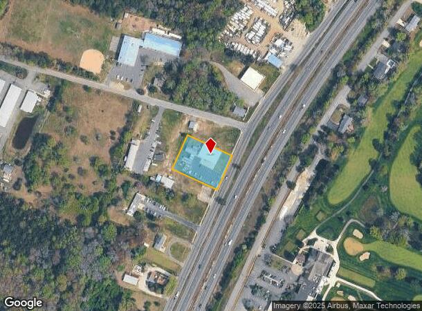
Property Record
1167 Route 9 S, Cape May Court House, NJ 08210

NEARBY LISTINGS FOR SALE OR LEASE
Property Detail
1167 Route 9 S
06-00355-02-00025
Cape May
Storebuilding
New Jersey
X
25
34009C0237F
0.79 AC
2024
South Shore/Vineland
2025
Other Market Areas
022102
Ocean City, NJ
DEMOGRAPHICS near 1167 Route 9 S
1 Mile
3 Mile
5 Mile
2024 Total Population
1,464
6,435
27,738
2029 Population
1,290
5,663
27,257
Pop Growth 2024-2029
(11.89%)
(12.00%)
(1.73%)
Average Age
43
43
46
2024 Total Households
573
2,466
11,680
HH Growth 2024-2029
(14.14%)
(14.19%)
(2.11%)
Median Household Inc
$66,093
$73,200
$72,797
Avg Household Size
2.40
2.40
2.20
2024 Avg HH Vehicles
2.00
2.00
2.00
Median Home Value
$251,869
$256,565
$317,896
Median Year Built
1984
1982
1978
Nearby Places
Map Layers
Map Styles
 Street
 Aerial
- Restaurants
- Banks
- Shops
- Fitness
- Groceries
SALE & LEASE HISTORY
LISTING DATE
SALE/LEASE

May 29, 2021
For Sale
Nearby Properties
Address
Land Use
TOTAL SIZE
Lot Size
Zoning
Address
Land Use
TOTAL SIZE
Lot Size
Zoning
15.01 AC
TC
Address
Land Use
TOTAL SIZE
Lot Size
Zoning
60.73 AC
R
Address
Land Use
TOTAL SIZE
Lot Size
Zoning
7.93 AC
TB
Address
Land Use
TOTAL SIZE
Lot Size
Zoning
970 SF
12.30 AC
TBTR
Address
Land Use
TOTAL SIZE
Lot Size
Zoning
19.18 AC
TC
Address
Land Use
TOTAL SIZE
Lot Size
Zoning
18.61 AC
TC
Address
Land Use
TOTAL SIZE
Lot Size
Zoning
22.90 AC
TB
Address
Land Use
TOTAL SIZE
Lot Size
Zoning
7.98 AC
TCRC
Address
Land Use
TOTAL SIZE
Lot Size
Zoning
17.56 AC
TC
Address
Land Use
TOTAL SIZE
Lot Size
Zoning
9.80 AC
R
Address
Land Use
TOTAL SIZE
Lot Size
Zoning
Address
Land Use
TOTAL SIZE
Lot Size
Zoning
6.37 AC
TB
Address
Land Use
TOTAL SIZE
Lot Size
Zoning
5.71 AC
TB
Address
Land Use
TOTAL SIZE
Lot Size
Zoning
98.94 AC
TCRC
Address
Land Use
TOTAL SIZE
Lot Size
Zoning
46.08 AC
SR
Address
Land Use
TOTAL SIZE
Lot Size
Zoning
11.28 AC
TB
Address
Land Use
TOTAL SIZE
Lot Size
Zoning
2.50 AC
TC
Address
Land Use
TOTAL SIZE
Lot Size
Zoning
1,680 SF
1 AC
TB
Address
Land Use
TOTAL SIZE
Lot Size
Zoning
Address
Land Use
TOTAL SIZE
Lot Size
Zoning
5.18 AC
TC
Address
Land Use
TOTAL SIZE
Lot Size
Zoning
Address
Land Use
TOTAL SIZE
Lot Size
Zoning
15.90 AC
TC
Address
Land Use
TOTAL SIZE
Lot Size
Zoning
1.56 AC
TB
Address
Land Use
TOTAL SIZE
Lot Size
Zoning
Address
Land Use
TOTAL SIZE
Lot Size
Zoning
63.25 AC
SR
Address
Land Use
TOTAL SIZE
Lot Size
Zoning
Address
Land Use
TOTAL SIZE
Lot Size
Zoning
15.16 AC
TC
Address
Land Use
TOTAL SIZE
Lot Size
Zoning
1,794 SF
13.55 AC
TC
Address
Land Use
TOTAL SIZE
Lot Size
Zoning
3,354 SF
4.42 AC
TPTR
Address
Land Use
TOTAL SIZE
Lot Size
Zoning
121.59 AC
RC
The World's #1 Commercial Real Estate Marketplace
Connect with us
© 2025 CoStar Group
The information above has been obtained from sources believed reliable. While we do not doubt its accuracy we have not verified it and make no guarantee, warranty or representation about it. It is your responsibility to independently confirm its accuracy and completeness. Any projections, opinions, assumptions, or estimates used are for example only and do not represent the current or future performance of the property. The value of this transaction to you depends on tax and other factors which should be evaluated by your tax, financial, and legal advisors. You and your advisors should conduct a careful, independent investigation of the property to determine to your satisfaction the suitability of the property for your needs.