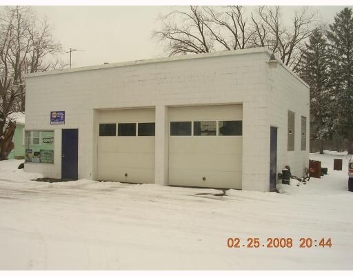
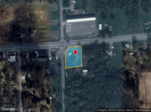
Property Record
11675 Broadway St, Alden, NY 14004
NEARBY LISTINGS FOR SALE OR LEASE
Property Detail
11675 Broadway St
142089-118-000-0002-034-000
Holland Land Companys Surveya
Autorepair
Erie
X
New York
36029C0268H
34.000
2025
0.98 AC
2024
Outlying Erie County
014903
Buffalo/Niagara Falls
1,140 SF
Buffalo-Cheektowaga-Niagara Falls, NY
DEMOGRAPHICS near 11675 Broadway St
1 Mile
3 Mile
5 Mile
2024 Total Population
1,409
8,110
25,082
2029 Population
1,415
8,100
25,082
Pop Growth 2024-2029
+ 0.43%
(0.12%)
0.00%
Average Age
45
44
44
2024 Total Households
555
3,226
10,109
HH Growth 2024-2029
+ 0.36%
(0.22%)
(0.10%)
Median Household Inc
$81,322
$85,728
$83,517
Avg Household Size
2.50
2.50
2.40
2024 Avg HH Vehicles
2.00
2.00
2.00
Median Home Value
$224,157
$257,470
$274,207
Median Year Built
1967
1967
1974
Nearby Places
- Restaurants
- Banks
- Shops
- Fitness
- Groceries
PUBLIC TRANSPORTATION
COMMUTER RAIL
Buffalo Depew Station (Empire Service - Amtrak, Lake Shore Limited - Amtrak, Maple Leaf - Amtrak)
DRIVE
WALK
Distance
Buffalo Depew Station (Empire Service - Amtrak, Lake Shore Limited - Amtrak, Maple Leaf - Amtrak)
18 min
9.3 mi
Buffalo (Depew) (Toronto - New York - VIA Rail)
DRIVE
WALK
Distance
Buffalo (Depew) (Toronto - New York - VIA Rail)
18 min
9.3 mi
AIRPORT
Buffalo Niagara International
DRIVE
WALK
Distance
Buffalo Niagara International
23 min
13.3 mi
Niagara Falls International
DRIVE
WALK
Distance
Niagara Falls International
51 min
29.9 mi
Freight Ports
Albany, NY Port
DRIVE
WALK
Distance
Albany, NY Port
330 min
275.8 mi
Nearby Properties
Address
Land Use
TOTAL SIZE
Lot Size
Zoning
Address
Land Use
TOTAL SIZE
Lot Size
Zoning
196,051 SF
515.13 AC
R-3
Address
Land Use
TOTAL SIZE
Lot Size
Zoning
65,000 SF
102 AC
C-2
Address
Land Use
TOTAL SIZE
Lot Size
Zoning
178,748 SF
61.10 AC
Address
Land Use
TOTAL SIZE
Lot Size
Zoning
Address
Land Use
TOTAL SIZE
Lot Size
Zoning
3.27 AC
Address
Land Use
TOTAL SIZE
Lot Size
Zoning
7,400 SF
4.80 AC
C-R
Address
Land Use
TOTAL SIZE
Lot Size
Zoning
109,017 SF
13.20 AC
C1
Address
Land Use
TOTAL SIZE
Lot Size
Zoning
6,186 SF
39.57 AC
R-3
Address
Land Use
TOTAL SIZE
Lot Size
Zoning
Address
Land Use
TOTAL SIZE
Lot Size
Zoning
Address
Land Use
TOTAL SIZE
Lot Size
Zoning
48,675 SF
5.80 AC
C1
Address
Land Use
TOTAL SIZE
Lot Size
Zoning
Address
Land Use
TOTAL SIZE
Lot Size
Zoning
32,056 SF
25.20 AC
R-1
Address
Land Use
TOTAL SIZE
Lot Size
Zoning
24,146 SF
81 AC
COMM
Address
Land Use
TOTAL SIZE
Lot Size
Zoning
Address
Land Use
TOTAL SIZE
Lot Size
Zoning
Address
Land Use
TOTAL SIZE
Lot Size
Zoning
534,527 SF
152 AC
C-R
Address
Land Use
TOTAL SIZE
Lot Size
Zoning
Address
Land Use
TOTAL SIZE
Lot Size
Zoning
11,177 SF
4.58 AC
C1
Address
Land Use
TOTAL SIZE
Lot Size
Zoning
18,560 SF
5.45 AC
M-2
Address
Land Use
TOTAL SIZE
Lot Size
Zoning
9,496 SF
62.50 AC
R1
Address
Land Use
TOTAL SIZE
Lot Size
Zoning
26,500 SF
3.70 AC
R-3
Address
Land Use
TOTAL SIZE
Lot Size
Zoning
47,020 SF
5.03 AC
M-2
Address
Land Use
TOTAL SIZE
Lot Size
Zoning
13,450 SF
2 AC
C1
Address
Land Use
TOTAL SIZE
Lot Size
Zoning
3.58 AC
Address
Land Use
TOTAL SIZE
Lot Size
Zoning
9,636 SF
5.50 AC
C-2
Address
Land Use
TOTAL SIZE
Lot Size
Zoning
15,400 SF
12.70 AC
Address
Land Use
TOTAL SIZE
Lot Size
Zoning
Address
Land Use
TOTAL SIZE
Lot Size
Zoning
61,902 SF
2.40 AC
I1
Address
Land Use
TOTAL SIZE
Lot Size
Zoning
1,664 SF
8.42 AC
The World's #1 Commercial Real Estate Marketplace
Connect with us
© 2025 CoStar Group
The information above has been obtained from sources believed reliable. While we do not doubt its accuracy we have not verified it and make no guarantee, warranty or representation about it. It is your responsibility to independently confirm its accuracy and completeness. Any projections, opinions, assumptions, or estimates used are for example only and do not represent the current or future performance of the property. The value of this transaction to you depends on tax and other factors which should be evaluated by your tax, financial, and legal advisors. You and your advisors should conduct a careful, independent investigation of the property to determine to your satisfaction the suitability of the property for your needs.