Property Record
117 14Th Ave E, Sartell, MN 56377

Property Detail
117 14Th Ave E
St. Cloud, MN
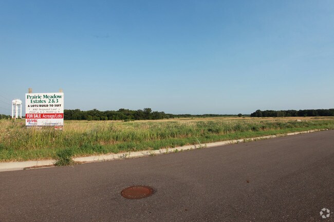
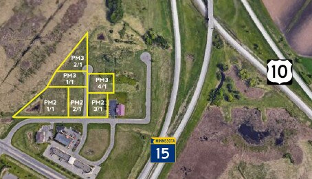
SECT-10 TWP-036 RANGE-031 PRAIRIE MEADOWS ESTATES 3 LOT-002 BLOCK-001
18.00548.00
BENTON
Commercialnec
Minnesota
B and X Area of moderate flood hazard, usually the area between the limits of the 100-year and 500-year floods.
2
2025
0.96 AC
2025
Benton County
020206
Minneapolis/St Paul
NEARBY LISTINGS FOR SALE OR LEASE
DEMOGRAPHICS near 117 14Th Ave E
1 mile
3 mile
5 mile
2025 Total Population
4,912
33,004
83,561
2030 Population
4,884
33,741
85,952
Pop Growth 2025-2030
(0.57%)
+ 2.23%
+ 2.86%
Average Age
42
39
37
2025 Total Households
2,187
13,461
33,375
HH Growth 2025-2030
(0.41%)
+ 2.25%
+ 2.91%
Median Household Inc
$55,624
$69,011
$66,167
Avg Household Size
2.10
2.40
2.30
2025 Avg HH Vehicles
2.00
2.00
2.00
Median Home Value
$261,867
$270,101
$246,674
Median Year Built
1986
1990
1984
Nearby Places
Map Layers
Map Styles
 Street
 Aerial
Transit
 Traffic
 Biking
Places
Listings with unknown addresses are not visible on the map
- Restaurants
- Banks
- Shops
- Fitness
- Groceries
PUBLIC TRANSPORTATION
COMMUTER RAIL
Drive
Walk
Distance
8 min
4.9 mi
SALE & LEASE HISTORY
LISTING DATE
SALE/LEASE

Sep 24, 2016
For Sale
Nov 01, 2016
For Sale
May 17, 2017
For Sale
Nearby Properties
Address
Land Use
TOTAL SIZE
Lot Size
Zoning
Address
Land Use
TOTAL SIZE
Lot Size
Zoning
362,000 SF
86.20 AC
Address
Land Use
TOTAL SIZE
Lot Size
Zoning
250,584 SF
77.75 AC
Address
Land Use
TOTAL SIZE
Lot Size
Zoning
183,964 SF
39.05 AC
Address
Land Use
TOTAL SIZE
Lot Size
Zoning
10,800 SF
24.94 AC
Address
Land Use
TOTAL SIZE
Lot Size
Zoning
Address
Land Use
TOTAL SIZE
Lot Size
Zoning
11.82 AC
Address
Land Use
TOTAL SIZE
Lot Size
Zoning
30,096 SF
8.47 AC
Address
Land Use
TOTAL SIZE
Lot Size
Zoning
365,299 SF
28.68 AC
R1
Address
Land Use
TOTAL SIZE
Lot Size
Zoning
252,469 SF
35 AC
Address
Land Use
TOTAL SIZE
Lot Size
Zoning
10.46 AC
Address
Land Use
TOTAL SIZE
Lot Size
Zoning
149,778 SF
7.86 AC
Address
Land Use
TOTAL SIZE
Lot Size
Zoning
184,285 SF
13.37 AC
Address
Land Use
TOTAL SIZE
Lot Size
Zoning
88,000 SF
37.63 AC
Address
Land Use
TOTAL SIZE
Lot Size
Zoning
Address
Land Use
TOTAL SIZE
Lot Size
Zoning
232,274 SF
2.94 AC
R3
Address
Land Use
TOTAL SIZE
Lot Size
Zoning
15.78 AC
Address
Land Use
TOTAL SIZE
Lot Size
Zoning
105,123 SF
36.87 AC
R1
Address
Land Use
TOTAL SIZE
Lot Size
Zoning
127,460 SF
5 AC
Address
Land Use
TOTAL SIZE
Lot Size
Zoning
6.61 AC
Address
Land Use
TOTAL SIZE
Lot Size
Zoning
25,608 SF
6.96 AC
R5
Address
Land Use
TOTAL SIZE
Lot Size
Zoning
36,393 SF
6.28 AC
Address
Land Use
TOTAL SIZE
Lot Size
Zoning
9.75 AC
Address
Land Use
TOTAL SIZE
Lot Size
Zoning
197,115 SF
18.23 AC
Address
Land Use
TOTAL SIZE
Lot Size
Zoning
29,349 SF
4.83 AC
Address
Land Use
TOTAL SIZE
Lot Size
Zoning
43,302 SF
5.67 AC
Address
Land Use
TOTAL SIZE
Lot Size
Zoning
10.96 AC
Address
Land Use
TOTAL SIZE
Lot Size
Zoning
22,425 SF
5.54 AC
Address
Land Use
TOTAL SIZE
Lot Size
Zoning
91,625 SF
7.02 AC
Address
Land Use
TOTAL SIZE
Lot Size
Zoning
27,984 SF
10.39 AC
The World's #1 Commercial Real Estate Marketplace
Connect with us
© 2026 CoStar Group
The information above has been obtained from sources believed reliable. While we do not doubt its accuracy we have not verified it and make no guarantee, warranty or representation about it. It is your responsibility to independently confirm its accuracy and completeness. Any projections, opinions, assumptions, or estimates used are for example only and do not represent the current or future performance of the property. The value of this transaction to you depends on tax and other factors which should be evaluated by your tax, financial, and legal advisors. You and your advisors should conduct a careful, independent investigation of the property to determine to your satisfaction the suitability of the property for your needs.