Property Record
117 82Nd St, Lubbock, TX 79404
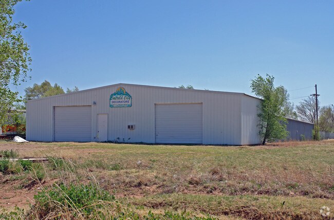

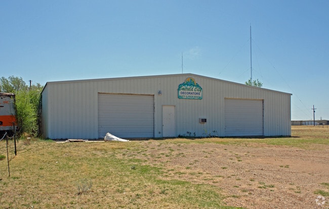
Property Detail
117 82Nd St
Lubbock, TX
BLK E SEC 8 AB 492 S150 OF TR A3 ACS: .275
R63493
Lubbock
Warehouse
Texas
AE The base floodplain where base flood elevations are provided. AE Zones are now used on new format FIRMs instead of A1-A30 Zones.
29
2024
0.28 AC
2025
Outlying Lubbock County
010513
Lubbock
10,550 SF
NEARBY LISTINGS FOR SALE OR LEASE
DEMOGRAPHICS near 117 82Nd St
1 mile
3 mile
5 mile
2025 Total Population
4,214
47,568
137,179
2030 Population
4,464
49,531
143,466
Pop Growth 2025-2030
+ 5.93%
+ 4.13%
+ 4.58%
Average Age
35
36
36
2025 Total Households
1,445
18,077
51,495
HH Growth 2025-2030
+ 6.37%
+ 4.30%
+ 5.00%
Median Household Inc
$70,861
$55,867
$57,408
Avg Household Size
2.70
2.50
2.40
2025 Avg HH Vehicles
2.00
2.00
2.00
Median Home Value
$152,803
$161,474
$205,426
Median Year Built
1999
1980
1979
Nearby Places
Map Layers
Map Styles
 Street
 Aerial
Transit
 Traffic
 Biking
Places
Listings with unknown addresses are not visible on the map
- Restaurants
- Banks
- Shops
- Fitness
- Groceries
PUBLIC TRANSPORTATION
AIRPORT
Lubbock Preston Smith International
Drive
Walk
Distance
Lubbock Preston Smith International
27 min
15.8 mi
SALE & LEASE HISTORY
LISTING DATE
SALE/LEASE

Jun 09, 2017
For Lease
Feb 15, 2018
For Lease
Nearby Properties
Address
Land Use
TOTAL SIZE
Lot Size
Zoning
Address
Land Use
TOTAL SIZE
Lot Size
Zoning
709,350 SF
98.60 AC
Address
Land Use
TOTAL SIZE
Lot Size
Zoning
176,165 SF
36.61 AC
Address
Land Use
TOTAL SIZE
Lot Size
Zoning
167,208 SF
10.09 AC
Address
Land Use
TOTAL SIZE
Lot Size
Zoning
169,139 SF
12.07 AC
Address
Land Use
TOTAL SIZE
Lot Size
Zoning
157,644 SF
9.69 AC
Address
Land Use
TOTAL SIZE
Lot Size
Zoning
76,680 SF
4.95 AC
Address
Land Use
TOTAL SIZE
Lot Size
Zoning
421,200 SF
43.22 AC
Address
Land Use
TOTAL SIZE
Lot Size
Zoning
202,036 SF
17.12 AC
Address
Land Use
TOTAL SIZE
Lot Size
Zoning
205,150 SF
23.43 AC
Address
Land Use
TOTAL SIZE
Lot Size
Zoning
71,329 SF
14 AC
Address
Land Use
TOTAL SIZE
Lot Size
Zoning
105,908 SF
9.78 AC
Address
Land Use
TOTAL SIZE
Lot Size
Zoning
24,084 SF
2.44 AC
Address
Land Use
TOTAL SIZE
Lot Size
Zoning
192,128 SF
9.87 AC
Address
Land Use
TOTAL SIZE
Lot Size
Zoning
121,899 SF
7.70 AC
Address
Land Use
TOTAL SIZE
Lot Size
Zoning
53,816 SF
1.32 AC
Address
Land Use
TOTAL SIZE
Lot Size
Zoning
131,497 SF
4.61 AC
Address
Land Use
TOTAL SIZE
Lot Size
Zoning
189,737 SF
31 AC
Address
Land Use
TOTAL SIZE
Lot Size
Zoning
88,310 SF
9.95 AC
Address
Land Use
TOTAL SIZE
Lot Size
Zoning
367,283 SF
36.77 AC
Address
Land Use
TOTAL SIZE
Lot Size
Zoning
113,156 SF
6.82 AC
Address
Land Use
TOTAL SIZE
Lot Size
Zoning
86,190 SF
6.60 AC
Address
Land Use
TOTAL SIZE
Lot Size
Zoning
137,554 SF
8.50 AC
Address
Land Use
TOTAL SIZE
Lot Size
Zoning
55,824 SF
2.28 AC
Address
Land Use
TOTAL SIZE
Lot Size
Zoning
62,226 SF
6.90 AC
Address
Land Use
TOTAL SIZE
Lot Size
Zoning
23,824 SF
1.82 AC
Address
Land Use
TOTAL SIZE
Lot Size
Zoning
69,391 SF
6.47 AC
Address
Land Use
TOTAL SIZE
Lot Size
Zoning
79,488 SF
5.23 AC
Address
Land Use
TOTAL SIZE
Lot Size
Zoning
87,030 SF
3.50 AC
Address
Land Use
TOTAL SIZE
Lot Size
Zoning
233,241 SF
12.52 AC
Address
Land Use
TOTAL SIZE
Lot Size
Zoning
40,720 SF
6.37 AC
The World's #1 Commercial Real Estate Marketplace
Connect with us
© 2026 CoStar Group
The information above has been obtained from sources believed reliable. While we do not doubt its accuracy we have not verified it and make no guarantee, warranty or representation about it. It is your responsibility to independently confirm its accuracy and completeness. Any projections, opinions, assumptions, or estimates used are for example only and do not represent the current or future performance of the property. The value of this transaction to you depends on tax and other factors which should be evaluated by your tax, financial, and legal advisors. You and your advisors should conduct a careful, independent investigation of the property to determine to your satisfaction the suitability of the property for your needs.