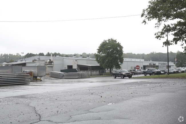
Property Record
117 Blake Dairy Rd, Belton, SC 29627

Save to a Folder
{{folder.Name}}
{{folder.ListingIds.length}} Properties
{{folder.ListingIds.length}} Property
Create a New Folder
Property Detail
117 Blake Dairy Rd
250-00-02-003
CP 093/380 F000 D000 PP 076/496 BLAKE DAIRY RD 54.55 AC
Industrialgeneral
Anderson
B and X Area of moderate flood hazard, usually the area between the limits of the 100-year and 500-year floods.
South Carolina
2025
54.55 AC
2025
Outlying Anderson Co
011402
Greenville/Spartanburg
158,791 SF
Greenville-Anderson-Greer, SC
NEARBY LISTINGS FOR SALE OR LEASE
DEMOGRAPHICS near 117 Blake Dairy Rd
1 mile
3 mile
5 mile
2025 Total Population
1,537
8,766
14,434
2030 Population
1,618
9,246
15,241
Pop Growth 2025-2030
+ 5.27%
+ 5.48%
+ 5.59%
Average Age
40
41
42
2025 Total Households
648
3,637
5,827
HH Growth 2025-2030
+ 5.40%
+ 5.69%
+ 5.78%
Median Household Inc
$45,980
$53,561
$60,072
Avg Household Size
2.40
2.40
2.40
2025 Avg HH Vehicles
2.00
2.00
2.00
Median Home Value
$183,838
$166,241
$178,657
Median Year Built
1964
1973
1979
Nearby Places
Map Layers
Map Styles
 Street
 Aerial
Layers
 Traffic
 Biking
Places
Listings with unknown addresses are not visible on the map
- Restaurants
- Banks
- Shops
- Fitness
- Groceries
SALE & LEASE HISTORY
LISTING DATE
SALE/LEASE

Feb 01, 2024
For Sale
Nearby Properties
Address
Land Use
TOTAL SIZE
Lot Size
Zoning
Address
Land Use
TOTAL SIZE
Lot Size
Zoning
230,048 SF
16.62 AC
Address
Land Use
TOTAL SIZE
Lot Size
Zoning
53,387 SF
2.57 AC
Address
Land Use
TOTAL SIZE
Lot Size
Zoning
186,092 SF
24.32 AC
Address
Land Use
TOTAL SIZE
Lot Size
Zoning
696 SF
4.57 AC
Address
Land Use
TOTAL SIZE
Lot Size
Zoning
720 SF
23.35 AC
Address
Land Use
TOTAL SIZE
Lot Size
Zoning
8,425 SF
1.37 AC
Address
Land Use
TOTAL SIZE
Lot Size
Zoning
59,545 SF
15.42 AC
Address
Land Use
TOTAL SIZE
Lot Size
Zoning
6,722 SF
5.02 AC
Address
Land Use
TOTAL SIZE
Lot Size
Zoning
12,276 SF
1.97 AC
Address
Land Use
TOTAL SIZE
Lot Size
Zoning
720 SF
15.48 AC
Address
Land Use
TOTAL SIZE
Lot Size
Zoning
6,231 SF
4.05 AC
Address
Land Use
TOTAL SIZE
Lot Size
Zoning
8,312 SF
7.50 AC
Address
Land Use
TOTAL SIZE
Lot Size
Zoning
2,070 SF
2.50 AC
Address
Land Use
TOTAL SIZE
Lot Size
Zoning
2,905 SF
1.13 AC
Address
Land Use
TOTAL SIZE
Lot Size
Zoning
8,988 SF
1.62 AC
Address
Land Use
TOTAL SIZE
Lot Size
Zoning
2,347 SF
1.38 AC
Address
Land Use
TOTAL SIZE
Lot Size
Zoning
59.40 AC
Address
Land Use
TOTAL SIZE
Lot Size
Zoning
50,849 SF
7.07 AC
Address
Land Use
TOTAL SIZE
Lot Size
Zoning
2,482 SF
5.93 AC
Address
Land Use
TOTAL SIZE
Lot Size
Zoning
2,619 SF
1.03 AC
Address
Land Use
TOTAL SIZE
Lot Size
Zoning
3,421 SF
1.18 AC
Address
Land Use
TOTAL SIZE
Lot Size
Zoning
42,248 SF
2.22 AC
Address
Land Use
TOTAL SIZE
Lot Size
Zoning
2,774 SF
2.12 AC
Address
Land Use
TOTAL SIZE
Lot Size
Zoning
2,877 SF
1.17 AC
Address
Land Use
TOTAL SIZE
Lot Size
Zoning
14,970 SF
3.86 AC
Address
Land Use
TOTAL SIZE
Lot Size
Zoning
9,760 SF
2.92 AC
Address
Land Use
TOTAL SIZE
Lot Size
Zoning
54,666 SF
10.40 AC
Address
Land Use
TOTAL SIZE
Lot Size
Zoning
7,723 SF
12.98 AC
The World's #1 Commercial Real Estate Marketplace
Connect with us
© 2026 CoStar Group
The information above has been obtained from sources believed reliable. While we do not doubt its accuracy we have not verified it and make no guarantee, warranty or representation about it. It is your responsibility to independently confirm its accuracy and completeness. Any projections, opinions, assumptions, or estimates used are for example only and do not represent the current or future performance of the property. The value of this transaction to you depends on tax and other factors which should be evaluated by your tax, financial, and legal advisors. You and your advisors should conduct a careful, independent investigation of the property to determine to your satisfaction the suitability of the property for your needs.