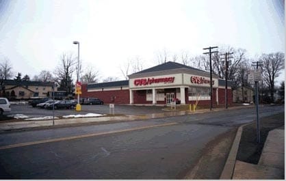
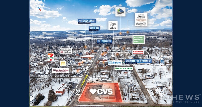
Property Record
117 E Main St, Sherman, NY 14781

Property Detail
117 E Main St
Jamestown-Dunkirk, NY
OLD APN: 066601 104-2-24
066601-328-011-0001-043-000
CHAUTAUQUA
Commercialacreage
New York
04 - FARM
43.000
2025
0.12 AC
2025
New York West Area
036700
Other Market Areas
NEARBY LISTINGS FOR SALE OR LEASE
-
-
View all Sherman listings for sale on LoopNet.com
DEMOGRAPHICS near 117 E Main St
1 mile
3 mile
5 mile
2025 Total Population
2,520
4,064
5,025
2030 Population
2,467
4,003
4,968
Pop Growth 2025-2030
(2.10%)
(1.50%)
(1.13%)
Average Age
45
46
46
2025 Total Households
1,114
1,776
2,183
HH Growth 2025-2030
(2.42%)
(1.80%)
(1.47%)
Median Household Inc
$46,465
$48,408
$49,296
Avg Household Size
2.20
2.20
2.20
2025 Avg HH Vehicles
1.00
2.00
2.00
Median Home Value
$103,025
$111,656
$119,173
Median Year Built
1952
1955
1957
Nearby Places
Map Layers
Map Styles
 Street
 Aerial
Layers
 Traffic
 Biking
Places
Listings with unknown addresses are not visible on the map
- Restaurants
- Banks
- Shops
- Fitness
- Groceries
SALE & LEASE HISTORY
LISTING DATE
SALE/LEASE

Feb 09, 2022
For Sale
Aug 10, 2022
For Sale
Apr 27, 2021
For Sale
Nearby Properties
Address
Land Use
TOTAL SIZE
Lot Size
Zoning
Address
Land Use
TOTAL SIZE
Lot Size
Zoning
2,676 SF
12.20 AC
Address
Land Use
TOTAL SIZE
Lot Size
Zoning
21.20 AC
Address
Land Use
TOTAL SIZE
Lot Size
Zoning
98,000 SF
2.90 AC
Address
Land Use
TOTAL SIZE
Lot Size
Zoning
9,100 SF
0.45 AC
Address
Land Use
TOTAL SIZE
Lot Size
Zoning
480 SF
0.28 AC
Address
Land Use
TOTAL SIZE
Lot Size
Zoning
Address
Land Use
TOTAL SIZE
Lot Size
Zoning
21,600 SF
5.40 AC
Address
Land Use
TOTAL SIZE
Lot Size
Zoning
0.01 AC
Address
Land Use
TOTAL SIZE
Lot Size
Zoning
12,012 SF
1.25 AC
Address
Land Use
TOTAL SIZE
Lot Size
Zoning
2,039 SF
33 AC
04 - FARM
Address
Land Use
TOTAL SIZE
Lot Size
Zoning
2,986 SF
2.80 AC
Address
Land Use
TOTAL SIZE
Lot Size
Zoning
164.10 AC
Address
Land Use
TOTAL SIZE
Lot Size
Zoning
3,840 SF
2.80 AC
61100
Address
Land Use
TOTAL SIZE
Lot Size
Zoning
179.80 AC
Address
Land Use
TOTAL SIZE
Lot Size
Zoning
0.05 AC
Address
Land Use
TOTAL SIZE
Lot Size
Zoning
168.60 AC
Address
Land Use
TOTAL SIZE
Lot Size
Zoning
768 SF
106 AC
Address
Land Use
TOTAL SIZE
Lot Size
Zoning
4,844 SF
2.30 AC
Address
Land Use
TOTAL SIZE
Lot Size
Zoning
1,176 SF
1 AC
04 - FARM
Address
Land Use
TOTAL SIZE
Lot Size
Zoning
186 AC
Address
Land Use
TOTAL SIZE
Lot Size
Zoning
2,673 SF
3 AC
Address
Land Use
TOTAL SIZE
Lot Size
Zoning
3,268 SF
0.40 AC
Address
Land Use
TOTAL SIZE
Lot Size
Zoning
1,800 SF
112 AC
Address
Land Use
TOTAL SIZE
Lot Size
Zoning
200.50 AC
Address
Land Use
TOTAL SIZE
Lot Size
Zoning
5,468 SF
0.25 AC
Address
Land Use
TOTAL SIZE
Lot Size
Zoning
2,711 SF
14.41 AC
Address
Land Use
TOTAL SIZE
Lot Size
Zoning
2,432 SF
0.75 AC
Address
Land Use
TOTAL SIZE
Lot Size
Zoning
Address
Land Use
TOTAL SIZE
Lot Size
Zoning
Address
Land Use
TOTAL SIZE
Lot Size
Zoning
5,954 SF
0.75 AC
The World's #1 Commercial Real Estate Marketplace
Connect with us
© 2026 CoStar Group
The information above has been obtained from sources believed reliable. While we do not doubt its accuracy we have not verified it and make no guarantee, warranty or representation about it. It is your responsibility to independently confirm its accuracy and completeness. Any projections, opinions, assumptions, or estimates used are for example only and do not represent the current or future performance of the property. The value of this transaction to you depends on tax and other factors which should be evaluated by your tax, financial, and legal advisors. You and your advisors should conduct a careful, independent investigation of the property to determine to your satisfaction the suitability of the property for your needs.