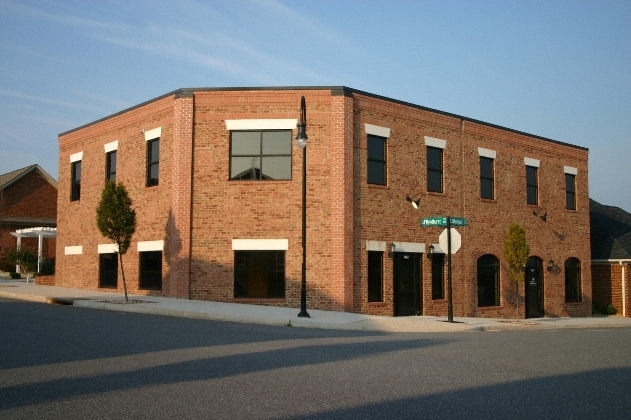
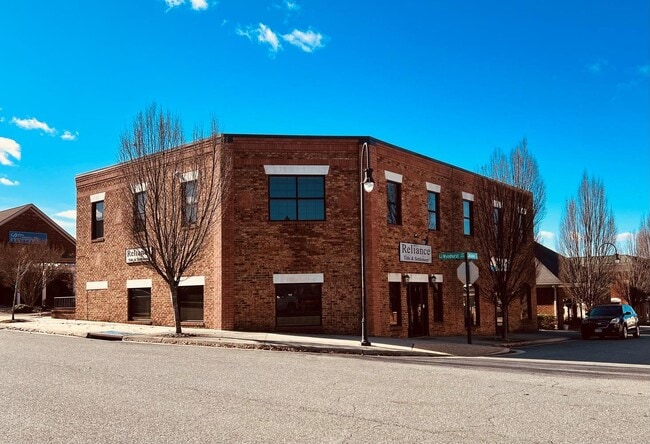
Property Record
117 Hexham Dr, Lynchburg, VA 24502
Current Lease Availabilities
NEARBY LISTINGS FOR SALE OR LEASE
Property Detail
117 Hexham Dr
Lynchburg, VA
Wyndhurst Town Center
250-16-011
TOWN CENTER AT WYNDHURST, BLK C, LOT 10
Storebuilding
Lynchburg City
X
Virginia
51019C0400D
10
2025
0.04 AC
2025
Wyndhurst
001700
Other Market Areas
2,788 SF
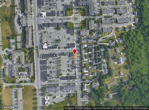
DEMOGRAPHICS near 117 Hexham Dr
1 Mile
3 Mile
5 Mile
2024 Total Population
6,407
42,230
80,627
2029 Population
6,368
42,578
81,206
Pop Growth 2024-2029
(0.61%)
+ 0.82%
+ 0.72%
Average Age
38
39
38
2024 Total Households
2,905
18,166
32,653
HH Growth 2024-2029
(0.55%)
+ 0.80%
+ 0.66%
Median Household Inc
$65,468
$61,544
$63,312
Avg Household Size
2.10
2.30
2.30
2024 Avg HH Vehicles
2.00
2.00
2.00
Median Home Value
$195,636
$198,082
$213,096
Median Year Built
1998
1987
1983
Nearby Places
Map Layers
Map Styles
 Street
 Aerial
- Restaurants
- Banks
- Shops
- Fitness
- Groceries
PUBLIC TRANSPORTATION
COMMUTER RAIL
DRIVE
WALK
Distance
15 min
8.4 mi
AIRPORT
Lynchburg Regional/Preston Glenn Field
DRIVE
WALK
Distance
Lynchburg Regional/Preston Glenn Field
11 min
3.8 mi
Nearby Properties
Address
Land Use
TOTAL SIZE
Lot Size
Zoning
Address
Land Use
TOTAL SIZE
Lot Size
Zoning
3.33 AC
1909
Address
Land Use
TOTAL SIZE
Lot Size
Zoning
22.70 AC
Address
Land Use
TOTAL SIZE
Lot Size
Zoning
912 SF
52.88 AC
BGC
Address
Land Use
TOTAL SIZE
Lot Size
Zoning
326,293 SF
80.06 AC
R1R3
Address
Land Use
TOTAL SIZE
Lot Size
Zoning
1,282 SF
12.75 AC
Address
Land Use
TOTAL SIZE
Lot Size
Zoning
207,379 SF
10.24 AC
250905
Address
Land Use
TOTAL SIZE
Lot Size
Zoning
4,672 SF
905.07 AC
BHC
Address
Land Use
TOTAL SIZE
Lot Size
Zoning
199,056 SF
16.21 AC
R1
Address
Land Use
TOTAL SIZE
Lot Size
Zoning
181,808 SF
39.61 AC
192921
Address
Land Use
TOTAL SIZE
Lot Size
Zoning
1,241 SF
7.20 AC
2519
Address
Land Use
TOTAL SIZE
Lot Size
Zoning
36,168 SF
7.96 AC
BGC
Address
Land Use
TOTAL SIZE
Lot Size
Zoning
155,125 SF
38.67 AC
250129
Address
Land Use
TOTAL SIZE
Lot Size
Zoning
9,508 SF
8.54 AC
RMF
Address
Land Use
TOTAL SIZE
Lot Size
Zoning
161,688 SF
16.57 AC
R3RC
Address
Land Use
TOTAL SIZE
Lot Size
Zoning
222,427 SF
23.56 AC
I2RC
Address
Land Use
TOTAL SIZE
Lot Size
Zoning
1,120 SF
16.81 AC
RMF
Address
Land Use
TOTAL SIZE
Lot Size
Zoning
3,478 SF
13.10 AC
RMFC
Address
Land Use
TOTAL SIZE
Lot Size
Zoning
537,608 SF
47.65 AC
152919
Address
Land Use
TOTAL SIZE
Lot Size
Zoning
88,286 SF
11.85 AC
Address
Land Use
TOTAL SIZE
Lot Size
Zoning
10.84 AC
R4RC
Address
Land Use
TOTAL SIZE
Lot Size
Zoning
94,608 SF
57.36 AC
2523
Address
Land Use
TOTAL SIZE
Lot Size
Zoning
8.29 AC
R3
Address
Land Use
TOTAL SIZE
Lot Size
Zoning
188,155 SF
18.49 AC
B3I2RC
Address
Land Use
TOTAL SIZE
Lot Size
Zoning
161,333 SF
10.60 AC
2119
Address
Land Use
TOTAL SIZE
Lot Size
Zoning
192,704 SF
8.35 AC
252905
Address
Land Use
TOTAL SIZE
Lot Size
Zoning
143,154 SF
15.37 AC
R5RC
Address
Land Use
TOTAL SIZE
Lot Size
Zoning
Address
Land Use
TOTAL SIZE
Lot Size
Zoning
71,626 SF
14.74 AC
B5
Address
Land Use
TOTAL SIZE
Lot Size
Zoning
47,505 SF
9.32 AC
I1
Address
Land Use
TOTAL SIZE
Lot Size
Zoning
76,421 SF
25.07 AC
R2RC
The World's #1 Commercial Real Estate Marketplace
Connect with us
© 2026 CoStar Group
The information above has been obtained from sources believed reliable. While we do not doubt its accuracy we have not verified it and make no guarantee, warranty or representation about it. It is your responsibility to independently confirm its accuracy and completeness. Any projections, opinions, assumptions, or estimates used are for example only and do not represent the current or future performance of the property. The value of this transaction to you depends on tax and other factors which should be evaluated by your tax, financial, and legal advisors. You and your advisors should conduct a careful, independent investigation of the property to determine to your satisfaction the suitability of the property for your needs.