Property Record
117 Highway, Willard, NC 28478
This Property Is For Sale
Property Detail
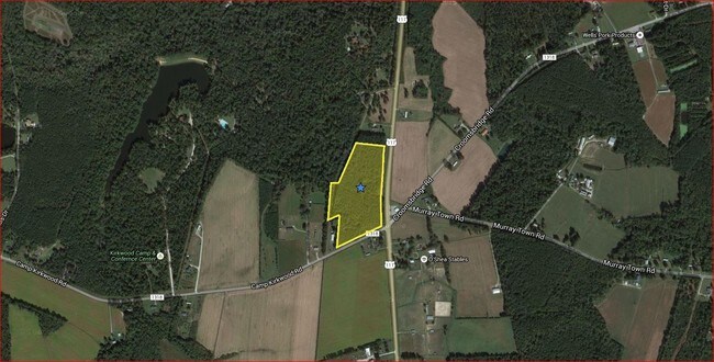
117 Highway
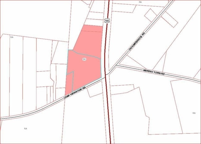
3322-44-7653-0000
1.00 AC W/S HWY 117
Vacantlandnec
PENDER
SEEMAP
North Carolina
B and X Area of moderate flood hazard, usually the area between the limits of the 100-year and 500-year floods.
7.92 AC
2025
East Pender County
2025
Wilmington
920300
Wilmington, NC
NEARBY LISTINGS FOR SALE OR LEASE
-
-
View all Willard listings for sale on LoopNet.com
DEMOGRAPHICS near 117 Highway
1 mile
3 mile
5 mile
2025 Total Population
331
1,583
3,483
2030 Population
378
1,804
3,977
Pop Growth 2025-2030
+ 14.20%
+ 13.96%
+ 14.18%
Average Age
42
42
43
2025 Total Households
135
639
1,391
HH Growth 2025-2030
+ 14.07%
+ 14.24%
+ 14.74%
Median Household Inc
$63,750
$64,008
$57,944
Avg Household Size
2.40
2.40
2.40
2025 Avg HH Vehicles
2.00
2.00
2.00
Median Home Value
$289,999
$250,909
$212,662
Median Year Built
1994
1994
1993
Nearby Places
Map Layers
Map Styles
 Street
 Aerial
Transit
 Traffic
 Biking
Places
Listings with unknown addresses are not visible on the map
- Restaurants
- Banks
- Shops
- Fitness
- Groceries
PUBLIC TRANSPORTATION
AIRPORT
Wilmington International
Drive
Walk
Distance
Wilmington International
44 min
27.4 mi
Albert J Ellis
Drive
Walk
Distance
Albert J Ellis
49 min
33.1 mi
Freight Ports
Port of Wilmington
Drive
Walk
Distance
Port of Wilmington
52 min
38.5 mi
Nearby Properties
Address
Land Use
TOTAL SIZE
Lot Size
Zoning
Address
Land Use
TOTAL SIZE
Lot Size
Zoning
25,131 SF
49.53 AC
Address
Land Use
TOTAL SIZE
Lot Size
Zoning
1,262.20 AC
RA
Address
Land Use
TOTAL SIZE
Lot Size
Zoning
451.69 AC
SEEMAP
Address
Land Use
TOTAL SIZE
Lot Size
Zoning
161.02 AC
RA
Address
Land Use
TOTAL SIZE
Lot Size
Zoning
533.76 AC
Address
Land Use
TOTAL SIZE
Lot Size
Zoning
282.59 AC
RA
Address
Land Use
TOTAL SIZE
Lot Size
Zoning
117.62 AC
RA
Address
Land Use
TOTAL SIZE
Lot Size
Zoning
4,744 SF
162.81 AC
SEEMAP
Address
Land Use
TOTAL SIZE
Lot Size
Zoning
147.50 AC
RA
Address
Land Use
TOTAL SIZE
Lot Size
Zoning
952 SF
74.72 AC
RA
Address
Land Use
TOTAL SIZE
Lot Size
Zoning
7,278 SF
1 AC
RA
Address
Land Use
TOTAL SIZE
Lot Size
Zoning
3,264 SF
3.63 AC
Address
Land Use
TOTAL SIZE
Lot Size
Zoning
4,800 SF
2.35 AC
RA
Address
Land Use
TOTAL SIZE
Lot Size
Zoning
5,843 SF
1.92 AC
RA
Address
Land Use
TOTAL SIZE
Lot Size
Zoning
153.28 AC
SEEMAP
Address
Land Use
TOTAL SIZE
Lot Size
Zoning
82.49 AC
RA
Address
Land Use
TOTAL SIZE
Lot Size
Zoning
3,472 SF
23.71 AC
RA
Address
Land Use
TOTAL SIZE
Lot Size
Zoning
2,383 SF
9 AC
RA
Address
Land Use
TOTAL SIZE
Lot Size
Zoning
78.11 AC
RA
Address
Land Use
TOTAL SIZE
Lot Size
Zoning
86.13 AC
RA
Address
Land Use
TOTAL SIZE
Lot Size
Zoning
784 SF
58.22 AC
Address
Land Use
TOTAL SIZE
Lot Size
Zoning
118.42 AC
RA
Address
Land Use
TOTAL SIZE
Lot Size
Zoning
11,840 SF
3.53 AC
Address
Land Use
TOTAL SIZE
Lot Size
Zoning
156.40 AC
SEEMAP
Address
Land Use
TOTAL SIZE
Lot Size
Zoning
66.39 AC
RA
Address
Land Use
TOTAL SIZE
Lot Size
Zoning
79.56 AC
RA
Address
Land Use
TOTAL SIZE
Lot Size
Zoning
3,216 SF
1.30 AC
RA
Address
Land Use
TOTAL SIZE
Lot Size
Zoning
3,320 SF
4.57 AC
RA
Address
Land Use
TOTAL SIZE
Lot Size
Zoning
652 SF
25.30 AC
RP
Address
Land Use
TOTAL SIZE
Lot Size
Zoning
101.80 AC
The World's #1 Commercial Real Estate Marketplace
Connect with us
© 2026 CoStar Group
The information above has been obtained from sources believed reliable. While we do not doubt its accuracy we have not verified it and make no guarantee, warranty or representation about it. It is your responsibility to independently confirm its accuracy and completeness. Any projections, opinions, assumptions, or estimates used are for example only and do not represent the current or future performance of the property. The value of this transaction to you depends on tax and other factors which should be evaluated by your tax, financial, and legal advisors. You and your advisors should conduct a careful, independent investigation of the property to determine to your satisfaction the suitability of the property for your needs.