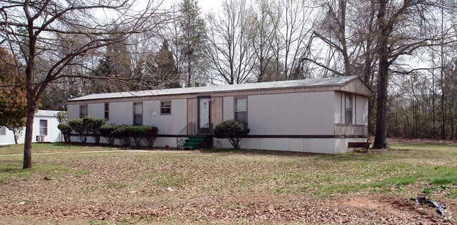
Property Record
117 Mcrogers Dr, Easley, SC 29640

NEARBY LISTINGS FOR SALE OR LEASE
Property Detail
117 Mcrogers Dr
Greenville-Anderson-Greer, SC
Survey For Op Partners
5019-06-48-7311
NE SIDE OLD CEDAR ROCK RD PLAT 25/674 PLAT 544/7, 1875 PLAT FILED UNDER MCDUFFIE HAMILTON IN GIS TR A PLAT 544/7
Residentialacreage
Pickens
AE
South Carolina
45077C0303D
75a
2024
17.81 AC
2024
Southeast Pickens County
010805
Greenville/Spartanburg
1,216 SF
DEMOGRAPHICS near 117 Mcrogers Dr
1 Mile
3 Mile
5 Mile
2024 Total Population
4,645
24,929
46,835
2029 Population
4,899
26,258
49,117
Pop Growth 2024-2029
+ 5.47%
+ 5.33%
+ 4.87%
Average Age
41
40
41
2024 Total Households
1,959
10,298
19,083
HH Growth 2024-2029
+ 5.56%
+ 5.47%
+ 4.96%
Median Household Inc
$42,590
$45,549
$53,240
Avg Household Size
2.30
2.40
2.40
2024 Avg HH Vehicles
2.00
2.00
2.00
Median Home Value
$136,761
$157,268
$175,826
Median Year Built
1974
1981
1986
Nearby Places
Map Layers
Map Styles
 Street
 Aerial
- Restaurants
- Banks
- Shops
- Fitness
- Groceries
PUBLIC TRANSPORTATION
AIRPORT
Greenville Spartanburg International
DRIVE
WALK
Distance
Greenville Spartanburg International
46 min
29.4 mi
Freight Ports
North Charleston Terminal
DRIVE
WALK
Distance
North Charleston Terminal
249 min
215.8 mi
Nearby Properties
Address
Land Use
TOTAL SIZE
Lot Size
Zoning
Address
Land Use
TOTAL SIZE
Lot Size
Zoning
2,291 SF
6.44 AC
GR2
Address
Land Use
TOTAL SIZE
Lot Size
Zoning
81,245 SF
8.49 AC
GC
Address
Land Use
TOTAL SIZE
Lot Size
Zoning
44,601 SF
3 AC
Address
Land Use
TOTAL SIZE
Lot Size
Zoning
10,906 SF
2.59 AC
CORE COMME
Address
Land Use
TOTAL SIZE
Lot Size
Zoning
24,362 SF
3.84 AC
GENERAL CO
Address
Land Use
TOTAL SIZE
Lot Size
Zoning
21.71 AC
GR2
Address
Land Use
TOTAL SIZE
Lot Size
Zoning
3,344 SF
3.04 AC
GR2
Address
Land Use
TOTAL SIZE
Lot Size
Zoning
9,800 SF
5.94 AC
R10
Address
Land Use
TOTAL SIZE
Lot Size
Zoning
3.60 AC
CORE COMME
Address
Land Use
TOTAL SIZE
Lot Size
Zoning
30,000 SF
3.30 AC
Address
Land Use
TOTAL SIZE
Lot Size
Zoning
220,956 SF
16.80 AC
GENERAL CO
Address
Land Use
TOTAL SIZE
Lot Size
Zoning
20,406 SF
1.26 AC
CORE COMME
Address
Land Use
TOTAL SIZE
Lot Size
Zoning
27,700 SF
12.91 AC
Address
Land Use
TOTAL SIZE
Lot Size
Zoning
39,480 SF
3.26 AC
Address
Land Use
TOTAL SIZE
Lot Size
Zoning
4,829 SF
2 AC
Address
Land Use
TOTAL SIZE
Lot Size
Zoning
180.03 AC
Address
Land Use
TOTAL SIZE
Lot Size
Zoning
8.96 AC
R 10 ONE F
Address
Land Use
TOTAL SIZE
Lot Size
Zoning
7.30 AC
R 10 ONE F
Address
Land Use
TOTAL SIZE
Lot Size
Zoning
4,450 SF
1.28 AC
MED MEDICA
Address
Land Use
TOTAL SIZE
Lot Size
Zoning
27.43 AC
R 10 ONE F
Address
Land Use
TOTAL SIZE
Lot Size
Zoning
7.09 AC
GC
Address
Land Use
TOTAL SIZE
Lot Size
Zoning
19.43 AC
Address
Land Use
TOTAL SIZE
Lot Size
Zoning
104,889 SF
10.68 AC
GC
Address
Land Use
TOTAL SIZE
Lot Size
Zoning
5,508 SF
4.78 AC
Address
Land Use
TOTAL SIZE
Lot Size
Zoning
3,299 SF
0.32 AC
GENERAL CO
Address
Land Use
TOTAL SIZE
Lot Size
Zoning
1,436 SF
1.62 AC
OC OFFICE
Address
Land Use
TOTAL SIZE
Lot Size
Zoning
55 AC
R 10 ONE F
Address
Land Use
TOTAL SIZE
Lot Size
Zoning
4,267 SF
0.77 AC
R 10 ONE F
Address
Land Use
TOTAL SIZE
Lot Size
Zoning
125,360 SF
15.26 AC
GENERAL CO
Address
Land Use
TOTAL SIZE
Lot Size
Zoning
9.07 AC
R 10 ONE F
The World's #1 Commercial Real Estate Marketplace
Connect with us
© 2026 CoStar Group
The information above has been obtained from sources believed reliable. While we do not doubt its accuracy we have not verified it and make no guarantee, warranty or representation about it. It is your responsibility to independently confirm its accuracy and completeness. Any projections, opinions, assumptions, or estimates used are for example only and do not represent the current or future performance of the property. The value of this transaction to you depends on tax and other factors which should be evaluated by your tax, financial, and legal advisors. You and your advisors should conduct a careful, independent investigation of the property to determine to your satisfaction the suitability of the property for your needs.