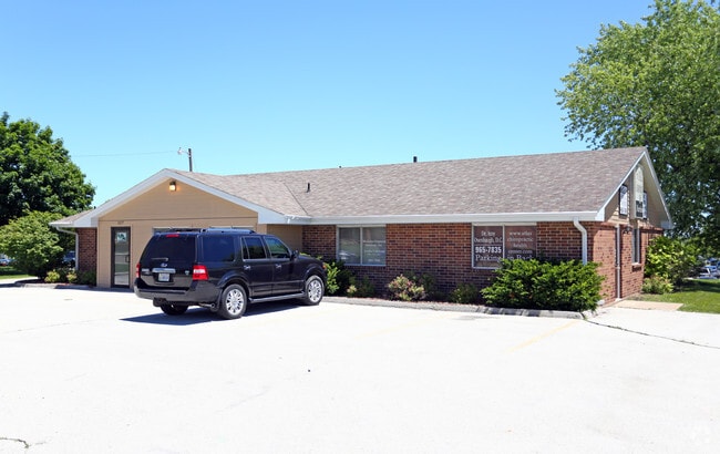
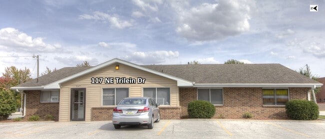
Property Record
117 Ne Trilein Dr, Ankeny, IA 50021

Current Lease Availabilities
Property Detail
117 Ne Trilein Dr
181-00422012002
S 55F LOT 12 & ALL N 1/2 LOT 13 HAYES ACRES PLAT 1
Officebuilding
Polk
C-2
Iowa
B and X Area of moderate flood hazard, usually the area between the limits of the 100-year and 500-year floods.
12,13
2024
0.45 AC
2025
Ankeny
010209
Des Moines
3,128 SF
Des Moines-West Des Moines, IA
NEARBY LISTINGS FOR SALE OR LEASE
DEMOGRAPHICS near 117 Ne Trilein Dr
1 mile
3 mile
5 mile
2025 Total Population
12,323
62,042
84,308
2030 Population
12,729
65,165
88,694
Pop Growth 2025-2030
+ 3.29%
+ 5.03%
+ 5.20%
Average Age
39
37
37
2025 Total Households
5,275
24,656
32,481
HH Growth 2025-2030
+ 3.56%
+ 5.15%
+ 5.30%
Median Household Inc
$93,210
$102,895
$108,361
Avg Household Size
2.30
2.50
2.50
2025 Avg HH Vehicles
2.00
2.00
2.00
Median Home Value
$272,157
$331,266
$348,339
Median Year Built
1989
2004
2005
Nearby Places
Map Layers
Map Styles
 Street
 Aerial
Transit
 Traffic
 Biking
Places
Listings with unknown addresses are not visible on the map
- Restaurants
- Banks
- Shops
- Fitness
- Groceries
PUBLIC TRANSPORTATION
AIRPORT
Des Moines International
Drive
Walk
Distance
Des Moines International
29 min
17.7 mi
Nearby Properties
Address
Land Use
TOTAL SIZE
Lot Size
Zoning
Address
Land Use
TOTAL SIZE
Lot Size
Zoning
2,732,552 SF
443.35 AC
Address
Land Use
TOTAL SIZE
Lot Size
Zoning
723,056 SF
83.96 AC
M1
Address
Land Use
TOTAL SIZE
Lot Size
Zoning
519,216 SF
42.20 AC
Address
Land Use
TOTAL SIZE
Lot Size
Zoning
463,530 SF
35.91 AC
M-1
Address
Land Use
TOTAL SIZE
Lot Size
Zoning
272,072 SF
11.70 AC
Address
Land Use
TOTAL SIZE
Lot Size
Zoning
296,500 SF
24.36 AC
Address
Land Use
TOTAL SIZE
Lot Size
Zoning
210,696 SF
6.57 AC
Address
Land Use
TOTAL SIZE
Lot Size
Zoning
644,942 SF
60.73 AC
M-1
Address
Land Use
TOTAL SIZE
Lot Size
Zoning
100,751 SF
12.67 AC
C-2
Address
Land Use
TOTAL SIZE
Lot Size
Zoning
263,250 SF
30.10 AC
M-1
Address
Land Use
TOTAL SIZE
Lot Size
Zoning
192,668 SF
20.73 AC
Address
Land Use
TOTAL SIZE
Lot Size
Zoning
198,454 SF
12.04 AC
Address
Land Use
TOTAL SIZE
Lot Size
Zoning
254,801 SF
20.05 AC
Address
Land Use
TOTAL SIZE
Lot Size
Zoning
140,045 SF
9.29 AC
Address
Land Use
TOTAL SIZE
Lot Size
Zoning
143,249 SF
7.19 AC
Address
Land Use
TOTAL SIZE
Lot Size
Zoning
90,381 SF
19.28 AC
R-3
Address
Land Use
TOTAL SIZE
Lot Size
Zoning
143,012 SF
1.75 AC
Address
Land Use
TOTAL SIZE
Lot Size
Zoning
170,692 SF
6.54 AC
Address
Land Use
TOTAL SIZE
Lot Size
Zoning
96,344 SF
13.39 AC
PUD
Address
Land Use
TOTAL SIZE
Lot Size
Zoning
63,664 SF
9.02 AC
Address
Land Use
TOTAL SIZE
Lot Size
Zoning
175,424 SF
8.01 AC
Address
Land Use
TOTAL SIZE
Lot Size
Zoning
162,384 SF
11.16 AC
R-3
Address
Land Use
TOTAL SIZE
Lot Size
Zoning
211,986 SF
20.98 AC
Address
Land Use
TOTAL SIZE
Lot Size
Zoning
144,992 SF
6.03 AC
Address
Land Use
TOTAL SIZE
Lot Size
Zoning
174,602 SF
15.47 AC
Address
Land Use
TOTAL SIZE
Lot Size
Zoning
116,213 SF
11.01 AC
C2
Address
Land Use
TOTAL SIZE
Lot Size
Zoning
122,066 SF
5.27 AC
Address
Land Use
TOTAL SIZE
Lot Size
Zoning
138,483 SF
10.02 AC
Address
Land Use
TOTAL SIZE
Lot Size
Zoning
150,733 SF
18.57 AC
M-1
Address
Land Use
TOTAL SIZE
Lot Size
Zoning
51,004 SF
4.39 AC
PUD
The World's #1 Commercial Real Estate Marketplace
Connect with us
© 2026 CoStar Group
The information above has been obtained from sources believed reliable. While we do not doubt its accuracy we have not verified it and make no guarantee, warranty or representation about it. It is your responsibility to independently confirm its accuracy and completeness. Any projections, opinions, assumptions, or estimates used are for example only and do not represent the current or future performance of the property. The value of this transaction to you depends on tax and other factors which should be evaluated by your tax, financial, and legal advisors. You and your advisors should conduct a careful, independent investigation of the property to determine to your satisfaction the suitability of the property for your needs.