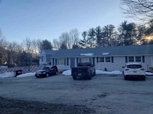
Property Record
117 Rockingham Rd, Windham, NH 03087


NEARBY LISTINGS FOR SALE OR LEASE
-
-
View all Windham listings for sale on LoopNet.com
Property Detail
117 Rockingham Rd
WNDM-000003-B000000-000110
Rockingham
Commercialofficeresidentialmixeduse
New Hampshire
X
110
33015C0534E
1.41 AC
2024
Rockingham
2024
Boston
106101
Boston-Cambridge-Newton, MA-NH
1,796 SF
DEMOGRAPHICS near 117 Rockingham Rd
1 Mile
3 Mile
5 Mile
2024 Total Population
1,001
18,717
63,421
2029 Population
1,036
19,410
65,850
Pop Growth 2024-2029
+ 3.50%
+ 3.70%
+ 3.83%
Average Age
41
43
43
2024 Total Households
332
6,671
24,264
HH Growth 2024-2029
+ 3.61%
+ 3.67%
+ 3.87%
Median Household Inc
$157,547
$131,960
$112,188
Avg Household Size
2.90
2.70
2.60
2024 Avg HH Vehicles
2.00
2.00
2.00
Median Home Value
$662,751
$465,395
$428,418
Median Year Built
2002
1984
1981
Nearby Places
Map Layers
Map Styles
 Street
 Aerial
- Restaurants
- Banks
- Shops
- Fitness
- Groceries
PUBLIC TRANSPORTATION
AIRPORT
Manchester Boston Regional
DRIVE
WALK
Distance
Manchester Boston Regional
32 min
18.7 mi
Portsmouth International at Pease
DRIVE
WALK
Distance
Portsmouth International at Pease
61 min
41.4 mi
Freight Ports
Port of Boston
DRIVE
WALK
Distance
Port of Boston
53 min
38.6 mi
SALE & LEASE HISTORY
LISTING DATE
SALE/LEASE

Apr 07, 2021
For Sale
Nearby Properties
Address
Land Use
TOTAL SIZE
Lot Size
Zoning
Address
Land Use
TOTAL SIZE
Lot Size
Zoning
72.18 AC
CIB
Address
Land Use
TOTAL SIZE
Lot Size
Zoning
297,592 SF
2.90 AC
CIC
Address
Land Use
TOTAL SIZE
Lot Size
Zoning
7.99 AC
CIB
Address
Land Use
TOTAL SIZE
Lot Size
Zoning
215,338 SF
66.52 AC
CIB
Address
Land Use
TOTAL SIZE
Lot Size
Zoning
21,433 SF
7.54 AC
LID
Address
Land Use
TOTAL SIZE
Lot Size
Zoning
63,628 SF
34.21 AC
CDA
Address
Land Use
TOTAL SIZE
Lot Size
Zoning
59,565 SF
41.20 AC
RD
Address
Land Use
TOTAL SIZE
Lot Size
Zoning
19,920 SF
15 AC
PBT
Address
Land Use
TOTAL SIZE
Lot Size
Zoning
59,626 SF
7.40 AC
VCD
Address
Land Use
TOTAL SIZE
Lot Size
Zoning
56,632 SF
14.20 AC
RUR
Address
Land Use
TOTAL SIZE
Lot Size
Zoning
7.21 AC
IND5
Address
Land Use
TOTAL SIZE
Lot Size
Zoning
3,602 SF
7.45 AC
RD
Address
Land Use
TOTAL SIZE
Lot Size
Zoning
13,673 SF
11.76 AC
CDA
Address
Land Use
TOTAL SIZE
Lot Size
Zoning
4.06 AC
CIB
Address
Land Use
TOTAL SIZE
Lot Size
Zoning
11,412 SF
4.21 AC
CDA
Address
Land Use
TOTAL SIZE
Lot Size
Zoning
320 SF
13.40 AC
RUR
Address
Land Use
TOTAL SIZE
Lot Size
Zoning
40,000 SF
7.53 AC
CDA
Address
Land Use
TOTAL SIZE
Lot Size
Zoning
23,964 SF
12.47 AC
MZ
Address
Land Use
TOTAL SIZE
Lot Size
Zoning
3,616 SF
17.77 AC
GC4
Address
Land Use
TOTAL SIZE
Lot Size
Zoning
23,544 SF
14.45 AC
CDB
Address
Land Use
TOTAL SIZE
Lot Size
Zoning
31,404 SF
7.10 AC
CDA
Address
Land Use
TOTAL SIZE
Lot Size
Zoning
42,720 SF
5.27 AC
LID
Address
Land Use
TOTAL SIZE
Lot Size
Zoning
26,262 SF
3.75 AC
CDA
Address
Land Use
TOTAL SIZE
Lot Size
Zoning
5.85 AC
CIB
Address
Land Use
TOTAL SIZE
Lot Size
Zoning
30.36 AC
GC
Address
Land Use
TOTAL SIZE
Lot Size
Zoning
10,752 SF
31.86 AC
MZ
Address
Land Use
TOTAL SIZE
Lot Size
Zoning
31,096 SF
14.47 AC
CDA
Address
Land Use
TOTAL SIZE
Lot Size
Zoning
23,160 SF
2.82 AC
GC
Address
Land Use
TOTAL SIZE
Lot Size
Zoning
3,200 SF
3.62 AC
VCD
Address
Land Use
TOTAL SIZE
Lot Size
Zoning
37,728 SF
24.56 AC
PBT
The World's #1 Commercial Real Estate Marketplace
Connect with us
© 2026 CoStar Group
The information above has been obtained from sources believed reliable. While we do not doubt its accuracy we have not verified it and make no guarantee, warranty or representation about it. It is your responsibility to independently confirm its accuracy and completeness. Any projections, opinions, assumptions, or estimates used are for example only and do not represent the current or future performance of the property. The value of this transaction to you depends on tax and other factors which should be evaluated by your tax, financial, and legal advisors. You and your advisors should conduct a careful, independent investigation of the property to determine to your satisfaction the suitability of the property for your needs.