Property Record
117 Rose St, Scotrun, PA 18355
NEARBY LISTINGS FOR SALE OR LEASE
-
-
-
-
No Photo
-
-
View all Scotrun listings for sale on LoopNet.com
Property Detail
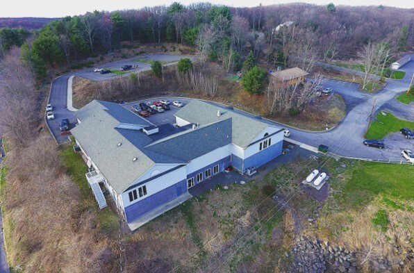
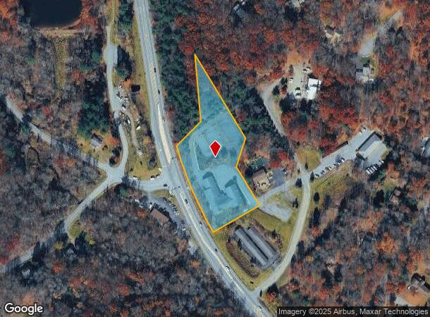
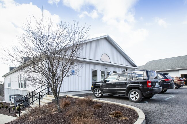
117 Rose St
12.6.1.17-1
Elevations Health Club
Officebuilding
JEFFREY & LINDA SNYDER SU
X
Monroe
42089C0254E
Pennsylvania
2025
2.53 AC
2025
Monroe County
300401
Philadelphia
19,882 SF
East Stroudsburg, PA
DEMOGRAPHICS near 117 Rose St
1 Mile
3 Mile
5 Mile
2024 Total Population
593
7,049
23,665
2029 Population
574
7,004
23,498
Pop Growth 2024-2029
(3.20%)
(0.64%)
(0.71%)
Average Age
46
44
43
2024 Total Households
248
2,764
8,971
HH Growth 2024-2029
(3.23%)
(0.65%)
(0.78%)
Median Household Inc
$91,885
$102,617
$86,753
Avg Household Size
2.40
2.50
2.60
2024 Avg HH Vehicles
2.00
2.00
2.00
Median Home Value
$227,500
$226,275
$225,826
Median Year Built
1979
1979
1984
Nearby Places
Map Layers
Map Styles
 Street
 Aerial
- Restaurants
- Banks
- Shops
- Fitness
- Groceries
PUBLIC TRANSPORTATION
AIRPORT
Lehigh Valley International
DRIVE
WALK
Distance
Lehigh Valley International
55 min
35.9 mi
Wilkes-Barre/Scranton International
DRIVE
WALK
Distance
Wilkes-Barre/Scranton International
55 min
40.7 mi
Freight Ports
Maher Terminal
DRIVE
WALK
Distance
Maher Terminal
105 min
81.0 mi
SALE & LEASE HISTORY
LISTING DATE
SALE/LEASE

Sep 25, 2016
For Lease
Nov 27, 2018
For Sale
Nov 01, 2018
For Sale
Apr 20, 2018
For Sale
Apr 17, 2019
For Sale
Nearby Properties
Address
Land Use
TOTAL SIZE
Lot Size
Zoning
Address
Land Use
TOTAL SIZE
Lot Size
Zoning
463,854 SF
95.86 AC
C
Address
Land Use
TOTAL SIZE
Lot Size
Zoning
1,132 SF
212.87 AC
I
Address
Land Use
TOTAL SIZE
Lot Size
Zoning
627,114 SF
896.17 AC
R-2
Address
Land Use
TOTAL SIZE
Lot Size
Zoning
11,060 SF
156.57 AC
R-2
Address
Land Use
TOTAL SIZE
Lot Size
Zoning
64,000 SF
23.31 AC
C
Address
Land Use
TOTAL SIZE
Lot Size
Zoning
124,288 SF
10.58 AC
C
Address
Land Use
TOTAL SIZE
Lot Size
Zoning
40,418 SF
78.43 AC
C
Address
Land Use
TOTAL SIZE
Lot Size
Zoning
133,288 SF
43.10 AC
R-2
Address
Land Use
TOTAL SIZE
Lot Size
Zoning
1,024 SF
147.49 AC
RD
Address
Land Use
TOTAL SIZE
Lot Size
Zoning
72,386 SF
19.74 AC
C
Address
Land Use
TOTAL SIZE
Lot Size
Zoning
40,320 SF
17.79 AC
C
Address
Land Use
TOTAL SIZE
Lot Size
Zoning
103,185 SF
39.71 AC
C
Address
Land Use
TOTAL SIZE
Lot Size
Zoning
38,158 SF
9.95 AC
C
Address
Land Use
TOTAL SIZE
Lot Size
Zoning
48,622 SF
2.47 AC
C
Address
Land Use
TOTAL SIZE
Lot Size
Zoning
9,450 SF
159 AC
R-1
Address
Land Use
TOTAL SIZE
Lot Size
Zoning
37,948 SF
47.53 AC
RR
Address
Land Use
TOTAL SIZE
Lot Size
Zoning
78,842 SF
7.24 AC
RD
Address
Land Use
TOTAL SIZE
Lot Size
Zoning
27,614 SF
36.14 AC
C
Address
Land Use
TOTAL SIZE
Lot Size
Zoning
5,952 SF
21.50 AC
C
Address
Land Use
TOTAL SIZE
Lot Size
Zoning
51,060 SF
7 AC
C
Address
Land Use
TOTAL SIZE
Lot Size
Zoning
7,488 SF
5.74 AC
C
Address
Land Use
TOTAL SIZE
Lot Size
Zoning
1,212 SF
1 AC
C
Address
Land Use
TOTAL SIZE
Lot Size
Zoning
62,147 SF
39.87 AC
C
Address
Land Use
TOTAL SIZE
Lot Size
Zoning
4,106 SF
4.32 AC
C
Address
Land Use
TOTAL SIZE
Lot Size
Zoning
21,900 SF
6.11 AC
R-1
Address
Land Use
TOTAL SIZE
Lot Size
Zoning
25,214 SF
11.39 AC
C
Address
Land Use
TOTAL SIZE
Lot Size
Zoning
19,634 SF
10.20 AC
RC
Address
Land Use
TOTAL SIZE
Lot Size
Zoning
9,184 SF
5.20 AC
C
Address
Land Use
TOTAL SIZE
Lot Size
Zoning
11,720 SF
0.10 AC
RD
Address
Land Use
TOTAL SIZE
Lot Size
Zoning
1,728 SF
127.62 AC
RD
The World's #1 Commercial Real Estate Marketplace
Connect with us
© 2025 CoStar Group
The information above has been obtained from sources believed reliable. While we do not doubt its accuracy we have not verified it and make no guarantee, warranty or representation about it. It is your responsibility to independently confirm its accuracy and completeness. Any projections, opinions, assumptions, or estimates used are for example only and do not represent the current or future performance of the property. The value of this transaction to you depends on tax and other factors which should be evaluated by your tax, financial, and legal advisors. You and your advisors should conduct a careful, independent investigation of the property to determine to your satisfaction the suitability of the property for your needs.