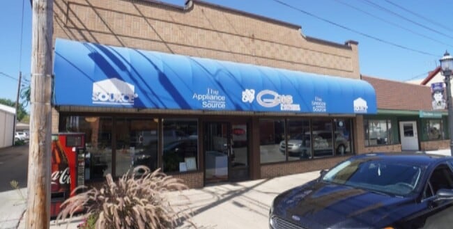
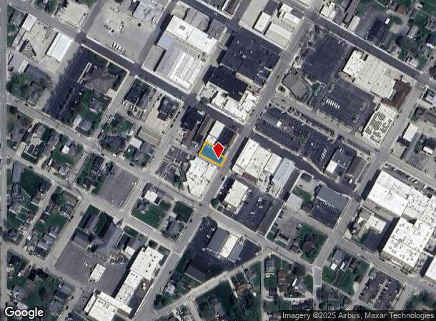
Property Record
117 S Main St, Batesville, IN 47006
NEARBY LISTINGS FOR SALE OR LEASE
-
-
View all Batesville listings for sale on LoopNet.com
Property Detail
117 S Main St
69-02-20-332-074.001-017
SIMS PT LOT 103 1/2 ALLEY VACATED 8 FT. X 60 FT.
Commercialnec
Ripley
X
Indiana
18047C0290D
103
2024
0.12 AC
2024
Indiana South Area
968500
Other Market Areas
6,720 SF
DEMOGRAPHICS near 117 S Main St
1 Mile
3 Mile
5 Mile
2024 Total Population
4,833
9,938
12,323
2029 Population
4,947
10,079
12,446
Pop Growth 2024-2029
+ 2.36%
+ 1.42%
+ 1.00%
Average Age
39
40
41
2024 Total Households
1,938
3,822
4,691
HH Growth 2024-2029
+ 2.37%
+ 1.39%
+ 0.96%
Median Household Inc
$57,564
$71,715
$72,823
Avg Household Size
2.40
2.50
2.50
2024 Avg HH Vehicles
2.00
2.00
2.00
Median Home Value
$183,204
$218,550
$227,347
Median Year Built
1972
1977
1978
Nearby Places
Map Layers
Map Styles
 Street
 Aerial
- Restaurants
- Banks
- Shops
- Fitness
- Groceries
SALE & LEASE HISTORY
LISTING DATE
SALE/LEASE

Mar 01, 2021
For Sale
Nearby Properties
Address
Land Use
TOTAL SIZE
Lot Size
Zoning
Address
Land Use
TOTAL SIZE
Lot Size
Zoning
56,160 SF
13.30 AC
Address
Land Use
TOTAL SIZE
Lot Size
Zoning
68,046 SF
55.45 AC
Address
Land Use
TOTAL SIZE
Lot Size
Zoning
8,295 SF
26.43 AC
Address
Land Use
TOTAL SIZE
Lot Size
Zoning
360,360 SF
12.67 AC
Address
Land Use
TOTAL SIZE
Lot Size
Zoning
79,826 SF
15.78 AC
Address
Land Use
TOTAL SIZE
Lot Size
Zoning
94,092 SF
22.99 AC
Address
Land Use
TOTAL SIZE
Lot Size
Zoning
137,765 SF
0.80 AC
Address
Land Use
TOTAL SIZE
Lot Size
Zoning
621,250 SF
13.80 AC
Address
Land Use
TOTAL SIZE
Lot Size
Zoning
72,745 SF
6.63 AC
Address
Land Use
TOTAL SIZE
Lot Size
Zoning
78,087 SF
10 AC
Address
Land Use
TOTAL SIZE
Lot Size
Zoning
9,808 SF
3.86 AC
Address
Land Use
TOTAL SIZE
Lot Size
Zoning
176,552 SF
3.40 AC
Address
Land Use
TOTAL SIZE
Lot Size
Zoning
51,606 SF
11.73 AC
Address
Land Use
TOTAL SIZE
Lot Size
Zoning
42,740 SF
12.12 AC
Address
Land Use
TOTAL SIZE
Lot Size
Zoning
45,666 SF
6.47 AC
Address
Land Use
TOTAL SIZE
Lot Size
Zoning
43,952 SF
3.73 AC
Address
Land Use
TOTAL SIZE
Lot Size
Zoning
39,090 SF
5.09 AC
Address
Land Use
TOTAL SIZE
Lot Size
Zoning
171,193 SF
22.55 AC
Address
Land Use
TOTAL SIZE
Lot Size
Zoning
15,911 SF
5.04 AC
Address
Land Use
TOTAL SIZE
Lot Size
Zoning
43,640 SF
4.90 AC
Address
Land Use
TOTAL SIZE
Lot Size
Zoning
10,998 SF
7.50 AC
Address
Land Use
TOTAL SIZE
Lot Size
Zoning
32,612 SF
2.66 AC
Address
Land Use
TOTAL SIZE
Lot Size
Zoning
133,805 SF
1.12 AC
Address
Land Use
TOTAL SIZE
Lot Size
Zoning
321,937 SF
7 AC
Address
Land Use
TOTAL SIZE
Lot Size
Zoning
17,500 SF
4.72 AC
Address
Land Use
TOTAL SIZE
Lot Size
Zoning
54,314 SF
8 AC
Address
Land Use
TOTAL SIZE
Lot Size
Zoning
27,806 SF
15.37 AC
Address
Land Use
TOTAL SIZE
Lot Size
Zoning
59,582 SF
8.98 AC
Address
Land Use
TOTAL SIZE
Lot Size
Zoning
23,290 SF
3.64 AC
Address
Land Use
TOTAL SIZE
Lot Size
Zoning
22,882 SF
1.04 AC
The World's #1 Commercial Real Estate Marketplace
Connect with us
© 2025 CoStar Group
The information above has been obtained from sources believed reliable. While we do not doubt its accuracy we have not verified it and make no guarantee, warranty or representation about it. It is your responsibility to independently confirm its accuracy and completeness. Any projections, opinions, assumptions, or estimates used are for example only and do not represent the current or future performance of the property. The value of this transaction to you depends on tax and other factors which should be evaluated by your tax, financial, and legal advisors. You and your advisors should conduct a careful, independent investigation of the property to determine to your satisfaction the suitability of the property for your needs.