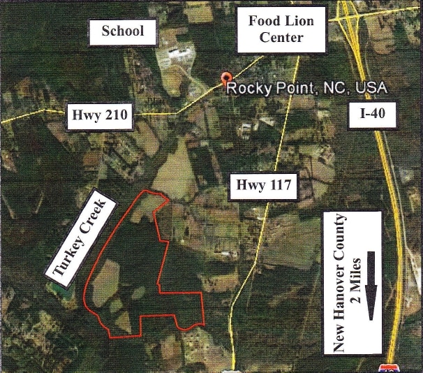
Property Record
117 S S Us Hwy, Rocky Point, NC 28457

NEARBY LISTINGS FOR SALE OR LEASE
Property Detail
117 S S Us Hwy
3234-24-6900-0000
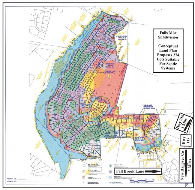
TR 2 PB 52/101 RECOMB TURKEY CR
Vacantlandnec
Pender
AE
North Carolina
3720322400J
208.64 AC
2024
West Pender County
2024
Wilmington
920601
Wilmington, NC
DEMOGRAPHICS near 117 S S Us Hwy
1 Mile
3 Mile
5 Mile
2024 Total Population
917
6,578
11,520
2029 Population
1,111
7,992
13,842
Pop Growth 2024-2029
+ 21.16%
+ 21.50%
+ 20.16%
Average Age
39
40
40
2024 Total Households
325
2,397
4,257
HH Growth 2024-2029
+ 21.54%
+ 21.74%
+ 20.25%
Median Household Inc
$52,368
$53,267
$53,525
Avg Household Size
2.70
2.70
2.60
2024 Avg HH Vehicles
2.00
2.00
2.00
Median Home Value
$212,981
$213,656
$219,146
Median Year Built
1994
1995
1995
Nearby Places
Map Layers
Map Styles
 Street
 Aerial
- Restaurants
- Banks
- Shops
- Fitness
- Groceries
PUBLIC TRANSPORTATION
AIRPORT
Wilmington International
DRIVE
WALK
Distance
Wilmington International
24 min
12.3 mi
Freight Ports
Port of Wilmington
DRIVE
WALK
Distance
Port of Wilmington
33 min
20.2 mi
SALE & LEASE HISTORY
LISTING DATE
SALE/LEASE

Sep 24, 2016
For Sale
Feb 13, 2017
For Sale
Nearby Properties
Address
Land Use
TOTAL SIZE
Lot Size
Zoning
Address
Land Use
TOTAL SIZE
Lot Size
Zoning
139,693 SF
20 AC
OI
Address
Land Use
TOTAL SIZE
Lot Size
Zoning
110,024 SF
22.01 AC
SEEMAP
Address
Land Use
TOTAL SIZE
Lot Size
Zoning
20,016 SF
6.85 AC
RT
Address
Land Use
TOTAL SIZE
Lot Size
Zoning
1,120 SF
106.68 AC
SEEMAP
Address
Land Use
TOTAL SIZE
Lot Size
Zoning
22,684 SF
3 AC
B2
Address
Land Use
TOTAL SIZE
Lot Size
Zoning
27,322 SF
3.80 AC
B2
Address
Land Use
TOTAL SIZE
Lot Size
Zoning
25,371 SF
55.80 AC
SEEMAP
Address
Land Use
TOTAL SIZE
Lot Size
Zoning
800 SF
20.22 AC
B2
Address
Land Use
TOTAL SIZE
Lot Size
Zoning
8,422 SF
4.29 AC
B2
Address
Land Use
TOTAL SIZE
Lot Size
Zoning
19,076 SF
3.57 AC
GB
Address
Land Use
TOTAL SIZE
Lot Size
Zoning
6,416 SF
3.81 AC
B2
Address
Land Use
TOTAL SIZE
Lot Size
Zoning
15,209 SF
1.79 AC
B2
Address
Land Use
TOTAL SIZE
Lot Size
Zoning
15,000 SF
3.85 AC
B2
Address
Land Use
TOTAL SIZE
Lot Size
Zoning
5,332 SF
2.79 AC
B2
Address
Land Use
TOTAL SIZE
Lot Size
Zoning
Address
Land Use
TOTAL SIZE
Lot Size
Zoning
6,296 SF
1.03 AC
B2
Address
Land Use
TOTAL SIZE
Lot Size
Zoning
7,215 SF
3.42 AC
B2
Address
Land Use
TOTAL SIZE
Lot Size
Zoning
20,000 SF
13.86 AC
IT
Address
Land Use
TOTAL SIZE
Lot Size
Zoning
4,128 SF
1.09 AC
B2
Address
Land Use
TOTAL SIZE
Lot Size
Zoning
5,868 SF
1.24 AC
B2
Address
Land Use
TOTAL SIZE
Lot Size
Zoning
8,120 SF
1.38 AC
GB
Address
Land Use
TOTAL SIZE
Lot Size
Zoning
7,124 SF
3.43 AC
RT
Address
Land Use
TOTAL SIZE
Lot Size
Zoning
10,000 SF
1.66 AC
B2
Address
Land Use
TOTAL SIZE
Lot Size
Zoning
8,200 SF
5.28 AC
R20
Address
Land Use
TOTAL SIZE
Lot Size
Zoning
7,200 SF
2.45 AC
R20
Address
Land Use
TOTAL SIZE
Lot Size
Zoning
5,036 SF
1.64 AC
RT
Address
Land Use
TOTAL SIZE
Lot Size
Zoning
497.70 AC
Address
Land Use
TOTAL SIZE
Lot Size
Zoning
12,700 SF
5 AC
SEEMAP
Address
Land Use
TOTAL SIZE
Lot Size
Zoning
6,895 SF
1.01 AC
B2
Address
Land Use
TOTAL SIZE
Lot Size
Zoning
4,098 SF
1.49 AC
GB
The World's #1 Commercial Real Estate Marketplace
Connect with us
© 2025 CoStar Group
The information above has been obtained from sources believed reliable. While we do not doubt its accuracy we have not verified it and make no guarantee, warranty or representation about it. It is your responsibility to independently confirm its accuracy and completeness. Any projections, opinions, assumptions, or estimates used are for example only and do not represent the current or future performance of the property. The value of this transaction to you depends on tax and other factors which should be evaluated by your tax, financial, and legal advisors. You and your advisors should conduct a careful, independent investigation of the property to determine to your satisfaction the suitability of the property for your needs.