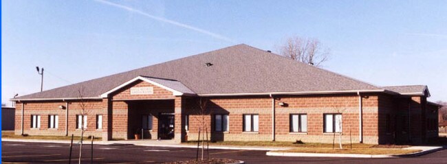
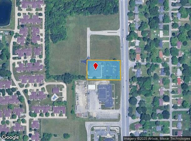
Property Record
117 S Scatterfield Rd, Anderson, IN 46012
NEARBY LISTINGS FOR SALE OR LEASE
Property Detail
117 S Scatterfield Rd
48-12-07-104-060.000-003
Pay Less 03 Street Centre Rep
Officebuilding
PAYLESS THIRD ST CENTRE RP 0.0000ACRES STR: SECTION: PLAT: IN: OUT:
X
Madison
18095C0257D
Indiana
2024
1.37 AC
2025
Anderson/Madison Cnty
001300
Indianapolis
12,912 SF
Indianapolis-Carmel-Anderson, IN
DEMOGRAPHICS near 117 S Scatterfield Rd
1 Mile
3 Mile
5 Mile
2024 Total Population
6,971
45,542
74,053
2029 Population
7,171
47,344
76,422
Pop Growth 2024-2029
+ 2.87%
+ 3.96%
+ 3.20%
Average Age
40
40
41
2024 Total Households
2,960
19,028
31,574
HH Growth 2024-2029
+ 3.04%
+ 4.12%
+ 3.31%
Median Household Inc
$46,459
$44,244
$47,139
Avg Household Size
2.10
2.20
2.20
2024 Avg HH Vehicles
2.00
2.00
2.00
Median Home Value
$127,073
$99,970
$115,750
Median Year Built
1963
1957
1962
Nearby Places
Map Layers
Map Styles
 Street
 Aerial
- Restaurants
- Banks
- Shops
- Fitness
- Groceries
SALE & LEASE HISTORY
LISTING DATE
SALE/LEASE

Sep 18, 2017
For Sale
Oct 16, 2017
For Sale
Nearby Properties
Address
Land Use
TOTAL SIZE
Lot Size
Zoning
Address
Land Use
TOTAL SIZE
Lot Size
Zoning
24,288 SF
19.39 AC
Address
Land Use
TOTAL SIZE
Lot Size
Zoning
75,580 SF
21 AC
Address
Land Use
TOTAL SIZE
Lot Size
Zoning
28,980 SF
9 AC
Address
Land Use
TOTAL SIZE
Lot Size
Zoning
19,855 SF
10.64 AC
Address
Land Use
TOTAL SIZE
Lot Size
Zoning
6,162 SF
27.97 AC
Address
Land Use
TOTAL SIZE
Lot Size
Zoning
36,120 SF
22.78 AC
Address
Land Use
TOTAL SIZE
Lot Size
Zoning
85,759 SF
11.11 AC
Address
Land Use
TOTAL SIZE
Lot Size
Zoning
119,012 SF
14.15 AC
Address
Land Use
TOTAL SIZE
Lot Size
Zoning
140,429 SF
18.58 AC
Address
Land Use
TOTAL SIZE
Lot Size
Zoning
59,160 SF
59.78 AC
Address
Land Use
TOTAL SIZE
Lot Size
Zoning
70,286 SF
3.89 AC
Address
Land Use
TOTAL SIZE
Lot Size
Zoning
13,032 SF
12.58 AC
Address
Land Use
TOTAL SIZE
Lot Size
Zoning
2,641 SF
24.33 AC
Address
Land Use
TOTAL SIZE
Lot Size
Zoning
70,860 SF
0.25 AC
Address
Land Use
TOTAL SIZE
Lot Size
Zoning
3,704 SF
10 AC
Address
Land Use
TOTAL SIZE
Lot Size
Zoning
79,422 SF
5.37 AC
Address
Land Use
TOTAL SIZE
Lot Size
Zoning
16,136 SF
9.39 AC
Address
Land Use
TOTAL SIZE
Lot Size
Zoning
74,538 SF
6.78 AC
Address
Land Use
TOTAL SIZE
Lot Size
Zoning
2,936 SF
10.52 AC
Address
Land Use
TOTAL SIZE
Lot Size
Zoning
57,535 SF
4.18 AC
Address
Land Use
TOTAL SIZE
Lot Size
Zoning
43,371 SF
4.60 AC
Address
Land Use
TOTAL SIZE
Lot Size
Zoning
72,158 SF
6 AC
Address
Land Use
TOTAL SIZE
Lot Size
Zoning
110,768 SF
0.17 AC
Address
Land Use
TOTAL SIZE
Lot Size
Zoning
31,000 SF
17.65 AC
Address
Land Use
TOTAL SIZE
Lot Size
Zoning
31,214 SF
0.19 AC
Address
Land Use
TOTAL SIZE
Lot Size
Zoning
421,323 SF
8.13 AC
Address
Land Use
TOTAL SIZE
Lot Size
Zoning
336,662 SF
32.16 AC
Address
Land Use
TOTAL SIZE
Lot Size
Zoning
44,891 SF
Address
Land Use
TOTAL SIZE
Lot Size
Zoning
17,901 SF
4.20 AC
Address
Land Use
TOTAL SIZE
Lot Size
Zoning
31,562 SF
7.60 AC
The World's #1 Commercial Real Estate Marketplace
Connect with us
© 2026 CoStar Group
The information above has been obtained from sources believed reliable. While we do not doubt its accuracy we have not verified it and make no guarantee, warranty or representation about it. It is your responsibility to independently confirm its accuracy and completeness. Any projections, opinions, assumptions, or estimates used are for example only and do not represent the current or future performance of the property. The value of this transaction to you depends on tax and other factors which should be evaluated by your tax, financial, and legal advisors. You and your advisors should conduct a careful, independent investigation of the property to determine to your satisfaction the suitability of the property for your needs.