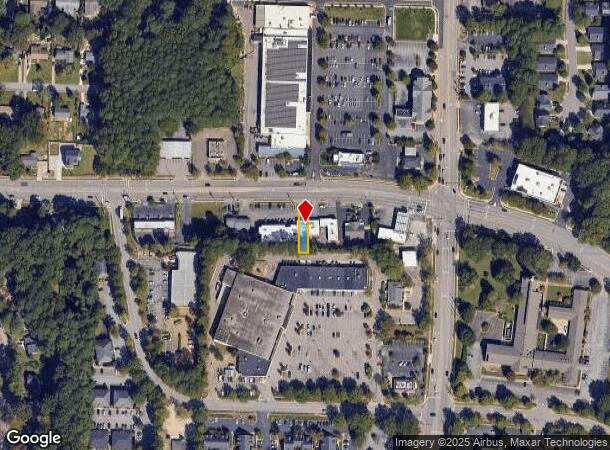
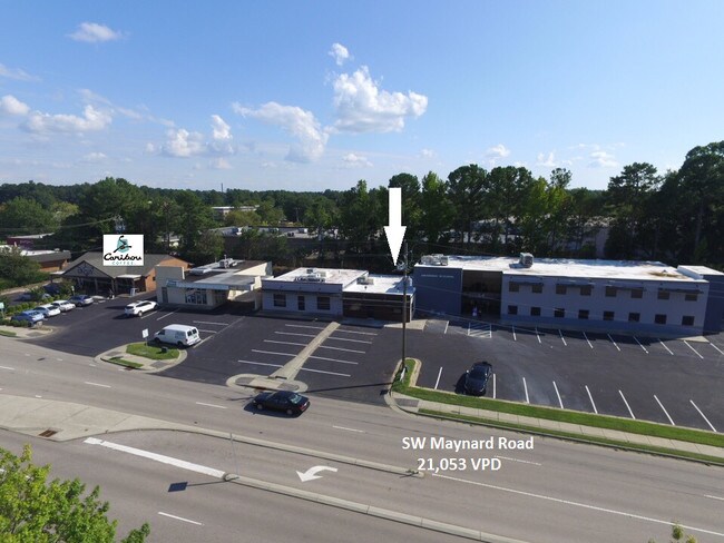
Property Record
117 Sw Maynard Rd, Cary, NC 27511
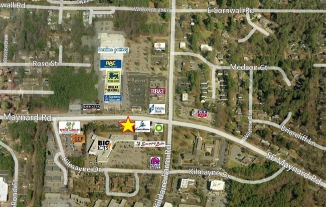
NEARBY LISTINGS FOR SALE OR LEASE
Property Detail
117 Sw Maynard Rd
0763.10-45-2681-000
4A
Commercialnec
S W MAYNARD ROAD TR4A BM2012-00364
X
Wake
3720076300K
North Carolina
2025
0.10 AC
2025
Cary
053519
Raleigh/Durham
1,563 SF
Raleigh, NC
DEMOGRAPHICS near 117 Sw Maynard Rd
1 Mile
3 Mile
5 Mile
2024 Total Population
10,673
85,553
191,384
2029 Population
11,558
92,703
207,501
Pop Growth 2024-2029
+ 8.29%
+ 8.36%
+ 8.42%
Average Age
45
40
39
2024 Total Households
4,732
36,025
79,291
HH Growth 2024-2029
+ 8.26%
+ 8.39%
+ 8.50%
Median Household Inc
$76,840
$91,439
$97,748
Avg Household Size
2.20
2.30
2.40
2024 Avg HH Vehicles
2.00
2.00
2.00
Median Home Value
$330,963
$384,212
$418,303
Median Year Built
1980
1990
1994
Nearby Places
Map Layers
Map Styles
 Street
 Aerial
- Restaurants
- Banks
- Shops
- Fitness
- Groceries
PUBLIC TRANSPORTATION
COMMUTER RAIL
Cary Station (Piedmont - North Carolina by Train (NC Train))
DRIVE
WALK
Distance
Cary Station (Piedmont - North Carolina by Train (NC Train))
4 min
1.5 mi
Raleigh Union Station (Piedmont - North Carolina by Train (NC Train))
DRIVE
WALK
Distance
Raleigh Union Station (Piedmont - North Carolina by Train (NC Train))
15 min
9.4 mi
AIRPORT
Raleigh-Durham International
DRIVE
WALK
Distance
Raleigh-Durham International
19 min
12.0 mi
Freight Ports
Port of Wilmington
DRIVE
WALK
Distance
Port of Wilmington
162 min
141.0 mi
SALE & LEASE HISTORY
LISTING DATE
SALE/LEASE

May 17, 2019
For Lease
Nearby Properties
Address
Land Use
TOTAL SIZE
Lot Size
Zoning
Address
Land Use
TOTAL SIZE
Lot Size
Zoning
693,180 SF
17.61 AC
GCM
Address
Land Use
TOTAL SIZE
Lot Size
Zoning
633,930 SF
23.01 AC
OI
Address
Land Use
TOTAL SIZE
Lot Size
Zoning
439,439 SF
30.59 AC
OICU
Address
Land Use
TOTAL SIZE
Lot Size
Zoning
433,914 SF
11.81 AC
MXD
Address
Land Use
TOTAL SIZE
Lot Size
Zoning
441,502 SF
15.42 AC
OIM
Address
Land Use
TOTAL SIZE
Lot Size
Zoning
429,107 SF
13.67 AC
RMFP
Address
Land Use
TOTAL SIZE
Lot Size
Zoning
450,107 SF
30.16 AC
HD MF
Address
Land Use
TOTAL SIZE
Lot Size
Zoning
395,263 SF
6.07 AC
CX-5
Address
Land Use
TOTAL SIZE
Lot Size
Zoning
392,141 SF
24.49 AC
RMFM
Address
Land Use
TOTAL SIZE
Lot Size
Zoning
453,970 SF
41.48 AC
RMF-C
Address
Land Use
TOTAL SIZE
Lot Size
Zoning
220,152 SF
67.76 AC
OIM
Address
Land Use
TOTAL SIZE
Lot Size
Zoning
402,447 SF
49.88 AC
GC
Address
Land Use
TOTAL SIZE
Lot Size
Zoning
359,022 SF
21.46 AC
OX-3
Address
Land Use
TOTAL SIZE
Lot Size
Zoning
435,090 SF
28.82 AC
RMFP
Address
Land Use
TOTAL SIZE
Lot Size
Zoning
269,702 SF
14.66 AC
GCM
Address
Land Use
TOTAL SIZE
Lot Size
Zoning
280,706 SF
15.38 AC
PUD-C
Address
Land Use
TOTAL SIZE
Lot Size
Zoning
341,943 SF
19.49 AC
RMFP
Address
Land Use
TOTAL SIZE
Lot Size
Zoning
290,022 SF
14.76 AC
RX-3
Address
Land Use
TOTAL SIZE
Lot Size
Zoning
364,972 SF
35.18 AC
RMF-C
Address
Land Use
TOTAL SIZE
Lot Size
Zoning
242,305 SF
48.57 AC
R40
Address
Land Use
TOTAL SIZE
Lot Size
Zoning
226,107 SF
18.72 AC
RMFP
Address
Land Use
TOTAL SIZE
Lot Size
Zoning
194,462 SF
21.62 AC
OICU
Address
Land Use
TOTAL SIZE
Lot Size
Zoning
330,232 SF
18.45 AC
OIP
Address
Land Use
TOTAL SIZE
Lot Size
Zoning
319,271 SF
38.96 AC
R12
Address
Land Use
TOTAL SIZE
Lot Size
Zoning
285,822 SF
24.57 AC
RMFP
Address
Land Use
TOTAL SIZE
Lot Size
Zoning
260,777 SF
22.54 AC
GCCU
Address
Land Use
TOTAL SIZE
Lot Size
Zoning
285,176 SF
31.09 AC
RMF
Address
Land Use
TOTAL SIZE
Lot Size
Zoning
270,753 SF
20.56 AC
RMFP
Address
Land Use
TOTAL SIZE
Lot Size
Zoning
185,064 SF
1.56 AC
GCP
Address
Land Use
TOTAL SIZE
Lot Size
Zoning
172,976 SF
12.55 AC
RMFM
The World's #1 Commercial Real Estate Marketplace
Connect with us
© 2025 CoStar Group
The information above has been obtained from sources believed reliable. While we do not doubt its accuracy we have not verified it and make no guarantee, warranty or representation about it. It is your responsibility to independently confirm its accuracy and completeness. Any projections, opinions, assumptions, or estimates used are for example only and do not represent the current or future performance of the property. The value of this transaction to you depends on tax and other factors which should be evaluated by your tax, financial, and legal advisors. You and your advisors should conduct a careful, independent investigation of the property to determine to your satisfaction the suitability of the property for your needs.