Property Record
117 Welpine Rd, Pendleton, SC 29670
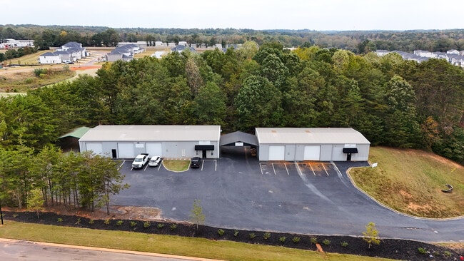

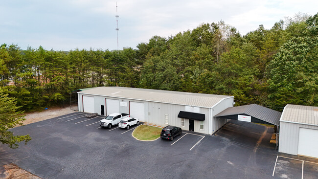
Property Detail
117 Welpine Rd
Greenville-Anderson-Greer, SC
CP S 3083/9 PP S 1420/2A F000 D000 WELPINE RD 1.35 AC
092-03-01-020
Anderson
Manufacturinglight
South Carolina
B and X Area of moderate flood hazard, usually the area between the limits of the 100-year and 500-year floods.
2
2025
1.35 AC
2024
Outlying Anderson Co
010602
Greenville/Spartanburg
3,232 SF
NEARBY LISTINGS FOR SALE OR LEASE
DEMOGRAPHICS near 117 Welpine Rd
1 mile
3 mile
5 mile
2024 Total Population
739
10,583
38,115
2029 Population
812
11,110
39,942
Pop Growth 2024-2029
+ 9.88%
+ 4.98%
+ 4.79%
Average Age
47
43
42
2024 Total Households
337
4,524
15,975
HH Growth 2024-2029
+ 10.39%
+ 5.28%
+ 5.05%
Median Household Inc
$69,617
$71,527
$70,461
Avg Household Size
2.20
2.30
2.30
2024 Avg HH Vehicles
2.00
2.00
2.00
Median Home Value
$364,062
$278,465
$267,299
Median Year Built
1997
1989
1988
Nearby Places
Map Layers
Map Styles
 Street
 Aerial
Transit
 Traffic
 Biking
Places
Listings with unknown addresses are not visible on the map
- Restaurants
- Banks
- Shops
- Fitness
- Groceries
PUBLIC TRANSPORTATION
AIRPORT
Greenville Spartanburg International
Drive
Walk
Distance
Greenville Spartanburg International
52 min
40.0 mi
SALE & LEASE HISTORY
LISTING DATE
SALE/LEASE

Oct 30, 2025
For Sale
Mar 06, 2024
For Lease
Jun 07, 2023
For Sale
Jul 09, 2024
For Sale
Feb 22, 2024
For Sale
Aug 22, 2023
For Lease
Nearby Properties
Address
Land Use
TOTAL SIZE
Lot Size
Zoning
Address
Land Use
TOTAL SIZE
Lot Size
Zoning
220.33 AC
Address
Land Use
TOTAL SIZE
Lot Size
Zoning
27,519 SF
20.80 AC
Address
Land Use
TOTAL SIZE
Lot Size
Zoning
152,326 SF
25.37 AC
Address
Land Use
TOTAL SIZE
Lot Size
Zoning
1,310 SF
31.53 AC
Address
Land Use
TOTAL SIZE
Lot Size
Zoning
21,030 SF
13.10 AC
Address
Land Use
TOTAL SIZE
Lot Size
Zoning
36,891 SF
3.14 AC
Address
Land Use
TOTAL SIZE
Lot Size
Zoning
118,242 SF
10.63 AC
Address
Land Use
TOTAL SIZE
Lot Size
Zoning
121,900 SF
11.39 AC
Address
Land Use
TOTAL SIZE
Lot Size
Zoning
53,002 SF
15.97 AC
Address
Land Use
TOTAL SIZE
Lot Size
Zoning
188,745 SF
20.01 AC
Address
Land Use
TOTAL SIZE
Lot Size
Zoning
138.61 AC
Address
Land Use
TOTAL SIZE
Lot Size
Zoning
135,174 SF
27.88 AC
Address
Land Use
TOTAL SIZE
Lot Size
Zoning
102,816 SF
28.36 AC
Address
Land Use
TOTAL SIZE
Lot Size
Zoning
68,593 SF
2.46 AC
Address
Land Use
TOTAL SIZE
Lot Size
Zoning
125,000 SF
24.88 AC
Address
Land Use
TOTAL SIZE
Lot Size
Zoning
63,040 SF
5.61 AC
Address
Land Use
TOTAL SIZE
Lot Size
Zoning
2,078 SF
44.20 AC
Address
Land Use
TOTAL SIZE
Lot Size
Zoning
Address
Land Use
TOTAL SIZE
Lot Size
Zoning
6,500 SF
7.41 AC
Address
Land Use
TOTAL SIZE
Lot Size
Zoning
9,211 SF
10.59 AC
Address
Land Use
TOTAL SIZE
Lot Size
Zoning
41,054 SF
2.04 AC
Address
Land Use
TOTAL SIZE
Lot Size
Zoning
23,043 SF
11.32 AC
Address
Land Use
TOTAL SIZE
Lot Size
Zoning
29,814 SF
4.57 AC
Address
Land Use
TOTAL SIZE
Lot Size
Zoning
42,922 SF
6.57 AC
Address
Land Use
TOTAL SIZE
Lot Size
Zoning
35,305 SF
1.93 AC
Address
Land Use
TOTAL SIZE
Lot Size
Zoning
22,266 SF
4.13 AC
Address
Land Use
TOTAL SIZE
Lot Size
Zoning
60,340 SF
7.53 AC
Address
Land Use
TOTAL SIZE
Lot Size
Zoning
533,102 SF
66.26 AC
Address
Land Use
TOTAL SIZE
Lot Size
Zoning
40,280 SF
3.42 AC
Address
Land Use
TOTAL SIZE
Lot Size
Zoning
4,032 SF
1.12 AC
The World's #1 Commercial Real Estate Marketplace
Connect with us
© 2026 CoStar Group
The information above has been obtained from sources believed reliable. While we do not doubt its accuracy we have not verified it and make no guarantee, warranty or representation about it. It is your responsibility to independently confirm its accuracy and completeness. Any projections, opinions, assumptions, or estimates used are for example only and do not represent the current or future performance of the property. The value of this transaction to you depends on tax and other factors which should be evaluated by your tax, financial, and legal advisors. You and your advisors should conduct a careful, independent investigation of the property to determine to your satisfaction the suitability of the property for your needs.