Property Record
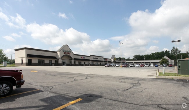
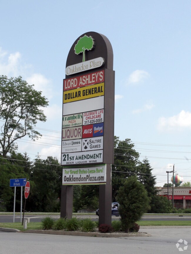
11703 Pendleton Pike, Indianapolis, IN 46236

Property Detail
11703 Pendleton Pike
49-01-33-132-007.000-407
PT SE1/4 SE1/4 S33 T17 R5 BEG 315 W OF SE COR W258.37 N 351.05 NE 150 SE 185.1 NE 232 NW184.72 SE 239.08 E 126.49 S 215.5 W 82.73SW 298.86 TO BEG 4.246AC (3.949AC TAX)
Regionalshoppingcenterormallwithanchorstore
MARION
ZO01
Indiana
B and X Area of moderate flood hazard, usually the area between the limits of the 100-year and 500-year floods.
4.25 AC
2024
North Shadeland
2025
Indianapolis
330212
Indianapolis-Carmel-Greenwood, IN
33,612 SF
NEARBY LISTINGS FOR SALE OR LEASE
DEMOGRAPHICS near 11703 Pendleton Pike
1 mile
3 mile
5 mile
2025 Total Population
6,005
48,422
137,186
2030 Population
6,043
49,325
140,345
Pop Growth 2025-2030
+ 0.63%
+ 1.86%
+ 2.30%
Average Age
39
38
38
2025 Total Households
2,098
17,870
51,974
HH Growth 2025-2030
+ 0.62%
+ 1.81%
+ 2.19%
Median Household Inc
$102,567
$95,355
$79,939
Avg Household Size
2.70
2.60
2.60
2025 Avg HH Vehicles
2.00
2.00
2.00
Median Home Value
$247,063
$277,243
$287,887
Median Year Built
1998
1996
1989
Nearby Places
Map Layers
Map Styles
 Street
 Aerial
Layers
 Traffic
 Biking
Places
Listings with unknown addresses are not visible on the map
- Restaurants
- Banks
- Shops
- Fitness
- Groceries
PUBLIC TRANSPORTATION
AIRPORT
Indianapolis International
Drive
Walk
Distance
Indianapolis International
49 min
28.0 mi
Freight Ports
Port of Toledo
Drive
Walk
Distance
Port of Toledo
254 min
211.1 mi
Nearby Properties
Address
Land Use
TOTAL SIZE
Lot Size
Zoning
Address
Land Use
TOTAL SIZE
Lot Size
Zoning
2,896,370 SF
54.48 AC
Address
Land Use
TOTAL SIZE
Lot Size
Zoning
77.34 AC
Address
Land Use
TOTAL SIZE
Lot Size
Zoning
67.17 AC
Address
Land Use
TOTAL SIZE
Lot Size
Zoning
986,112 SF
41.42 AC
Address
Land Use
TOTAL SIZE
Lot Size
Zoning
13.89 AC
Address
Land Use
TOTAL SIZE
Lot Size
Zoning
1,720 SF
63.09 AC
Address
Land Use
TOTAL SIZE
Lot Size
Zoning
61.67 AC
Address
Land Use
TOTAL SIZE
Lot Size
Zoning
2,398 SF
64.58 AC
Address
Land Use
TOTAL SIZE
Lot Size
Zoning
Address
Land Use
TOTAL SIZE
Lot Size
Zoning
11,154 SF
21.99 AC
Address
Land Use
TOTAL SIZE
Lot Size
Zoning
532,932 SF
61.88 AC
ZO03
Address
Land Use
TOTAL SIZE
Lot Size
Zoning
4,217 SF
7.37 AC
ZO01
Address
Land Use
TOTAL SIZE
Lot Size
Zoning
2,620 SF
32.36 AC
Address
Land Use
TOTAL SIZE
Lot Size
Zoning
390,106 SF
25.24 AC
Address
Land Use
TOTAL SIZE
Lot Size
Zoning
125,958 SF
54.85 AC
ZO01
Address
Land Use
TOTAL SIZE
Lot Size
Zoning
28.71 AC
Address
Land Use
TOTAL SIZE
Lot Size
Zoning
2,232 SF
22.88 AC
Address
Land Use
TOTAL SIZE
Lot Size
Zoning
136,336 SF
8.74 AC
ZO01
Address
Land Use
TOTAL SIZE
Lot Size
Zoning
259,780 SF
20.36 AC
Address
Land Use
TOTAL SIZE
Lot Size
Zoning
1,769 SF
18.27 AC
Address
Land Use
TOTAL SIZE
Lot Size
Zoning
27.17 AC
Address
Land Use
TOTAL SIZE
Lot Size
Zoning
3.39 AC
Address
Land Use
TOTAL SIZE
Lot Size
Zoning
24.25 AC
Address
Land Use
TOTAL SIZE
Lot Size
Zoning
2.71 AC
Address
Land Use
TOTAL SIZE
Lot Size
Zoning
16,836 SF
16.90 AC
Address
Land Use
TOTAL SIZE
Lot Size
Zoning
65,095 SF
4.06 AC
ZO01
Address
Land Use
TOTAL SIZE
Lot Size
Zoning
2,151 SF
11.05 AC
Address
Land Use
TOTAL SIZE
Lot Size
Zoning
88,772 SF
20.05 AC
Address
Land Use
TOTAL SIZE
Lot Size
Zoning
293,952 SF
12.88 AC
ZO01
Address
Land Use
TOTAL SIZE
Lot Size
Zoning
19.12 AC
The World's #1 Commercial Real Estate Marketplace
Connect with us
© 2026 CoStar Group
The information above has been obtained from sources believed reliable. While we do not doubt its accuracy we have not verified it and make no guarantee, warranty or representation about it. It is your responsibility to independently confirm its accuracy and completeness. Any projections, opinions, assumptions, or estimates used are for example only and do not represent the current or future performance of the property. The value of this transaction to you depends on tax and other factors which should be evaluated by your tax, financial, and legal advisors. You and your advisors should conduct a careful, independent investigation of the property to determine to your satisfaction the suitability of the property for your needs.