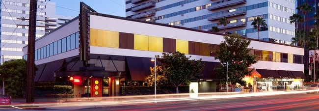
Property Record
11728 Wilshire Blvd, Los Angeles, CA 90025
Current Lease Availabilities
NEARBY LISTINGS FOR SALE OR LEASE
Property Detail
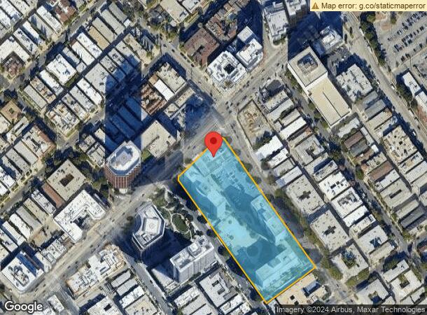
11728 Wilshire Blvd
Los Angeles-Long Beach-Glendale, CA
21962
4263-009-030
TRACT # 21962 LOT 1
Multifamilydwelling
Los Angeles
X
California
06037C1590G
1
2024
4.75 AC
2025
Brentwood
267404
Los Angeles
996,978 SF
DEMOGRAPHICS near 11728 Wilshire Blvd
1 Mile
3 Mile
5 Mile
2024 Total Population
51,169
263,553
557,136
2029 Population
50,145
259,690
546,863
Pop Growth 2024-2029
(2.00%)
(1.47%)
(1.84%)
Average Age
39
40
41
2024 Total Households
26,029
115,357
251,082
HH Growth 2024-2029
(2.25%)
(1.62%)
(2.00%)
Median Household Inc
$106,490
$106,615
$106,364
Avg Household Size
1.90
2.00
2.10
2024 Avg HH Vehicles
1.00
1.00
2.00
Median Home Value
$1,024,344
$1,104,021
$1,110,670
Median Year Built
1974
1971
1969
Nearby Places
- Restaurants
- Banks
- Shops
- Fitness
- Groceries
PUBLIC TRANSPORTATION
AIRPORT
Los Angeles International
DRIVE
WALK
Distance
Los Angeles International
20 min
10.4 mi
Bob Hope
DRIVE
WALK
Distance
Bob Hope
27 min
18.5 mi
Long Beach (Daugherty Field)
DRIVE
WALK
Distance
Long Beach (Daugherty Field)
31 min
28.8 mi
Nearby Properties
Address
Land Use
TOTAL SIZE
Lot Size
Zoning
Address
Land Use
TOTAL SIZE
Lot Size
Zoning
1,436,724 SF
21.11 AC
LAC2
Address
Land Use
TOTAL SIZE
Lot Size
Zoning
486,993 SF
8.31 AC
SMCP3-CP5*
Address
Land Use
TOTAL SIZE
Lot Size
Zoning
45,135 SF
1.69 AC
LARE9
Address
Land Use
TOTAL SIZE
Lot Size
Zoning
1,509,050 SF
113.39 AC
LAA1
Address
Land Use
TOTAL SIZE
Lot Size
Zoning
3.47 AC
LARE15
Address
Land Use
TOTAL SIZE
Lot Size
Zoning
0.29 AC
LARE
Address
Land Use
TOTAL SIZE
Lot Size
Zoning
597,158 SF
2.15 AC
LAC2
Address
Land Use
TOTAL SIZE
Lot Size
Zoning
1,353,044 SF
6.18 AC
LAC2
Address
Land Use
TOTAL SIZE
Lot Size
Zoning
227,227 SF
7.62 AC
BHC3*
Address
Land Use
TOTAL SIZE
Lot Size
Zoning
5.57 AC
LAC2
Address
Land Use
TOTAL SIZE
Lot Size
Zoning
33,373 SF
52.98 AC
LACCS
Address
Land Use
TOTAL SIZE
Lot Size
Zoning
1,029,337 SF
3.34 AC
LAC4
Address
Land Use
TOTAL SIZE
Lot Size
Zoning
618,301 SF
1.99 AC
LAC4
Address
Land Use
TOTAL SIZE
Lot Size
Zoning
840,124 SF
2.77 AC
LAC2
Address
Land Use
TOTAL SIZE
Lot Size
Zoning
318,556 SF
3.19 AC
SMC5*
Address
Land Use
TOTAL SIZE
Lot Size
Zoning
636,436 SF
6.62 AC
LAC2
Address
Land Use
TOTAL SIZE
Lot Size
Zoning
500,629 SF
1.60 AC
LAC4
Address
Land Use
TOTAL SIZE
Lot Size
Zoning
366,614 SF
4.25 AC
LAC4
Address
Land Use
TOTAL SIZE
Lot Size
Zoning
803,989 SF
LAC2
Address
Land Use
TOTAL SIZE
Lot Size
Zoning
1,232,625 SF
2.40 AC
LAC2
Address
Land Use
TOTAL SIZE
Lot Size
Zoning
1,226,598 SF
2.30 AC
LAC2
Address
Land Use
TOTAL SIZE
Lot Size
Zoning
824,156 SF
2.15 AC
LAC2
Address
Land Use
TOTAL SIZE
Lot Size
Zoning
767,078 SF
9.30 AC
LAC2
Address
Land Use
TOTAL SIZE
Lot Size
Zoning
858,380 SF
7.23 AC
SMC5*
Address
Land Use
TOTAL SIZE
Lot Size
Zoning
605,678 SF
LAC2
Address
Land Use
TOTAL SIZE
Lot Size
Zoning
808,626 SF
1.88 AC
LAC2
Address
Land Use
TOTAL SIZE
Lot Size
Zoning
35,635 SF
2.81 AC
LAC2
Address
Land Use
TOTAL SIZE
Lot Size
Zoning
483,875 SF
7.31 AC
SMC5*
Address
Land Use
TOTAL SIZE
Lot Size
Zoning
305,260 SF
1.36 AC
LAC4
Address
Land Use
TOTAL SIZE
Lot Size
Zoning
1,572,709 SF
4.34 AC
LAC2
The World's #1 Commercial Real Estate Marketplace
Connect with us
© 2025 CoStar Group
The information above has been obtained from sources believed reliable. While we do not doubt its accuracy we have not verified it and make no guarantee, warranty or representation about it. It is your responsibility to independently confirm its accuracy and completeness. Any projections, opinions, assumptions, or estimates used are for example only and do not represent the current or future performance of the property. The value of this transaction to you depends on tax and other factors which should be evaluated by your tax, financial, and legal advisors. You and your advisors should conduct a careful, independent investigation of the property to determine to your satisfaction the suitability of the property for your needs.