Property Record
1171 S Victoria Ave, Oxnard, CA 93035
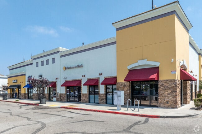

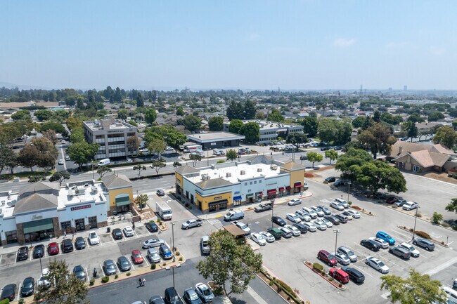
Property Detail
1171 S Victoria Ave
Oxnard-Thousand Oaks-Ventura, CA
LOT: 2 REF: 59 PM 36
137-0-051-085
Ventura
Storebuilding
California
B and X Area of moderate flood hazard, usually the area between the limits of the 100-year and 500-year floods.
2
2024
1.08 AC
2025
Ventura
001509
Los Angeles
8,098 SF
NEARBY LISTINGS FOR SALE OR LEASE
DEMOGRAPHICS near 1171 S Victoria Ave
1 mile
3 mile
5 mile
2025 Total Population
20,795
89,713
188,824
2030 Population
20,630
89,513
187,993
Pop Growth 2025-2030
(0.79%)
(0.22%)
(0.44%)
Average Age
41
42
40
2025 Total Households
8,095
33,035
63,992
HH Growth 2025-2030
(0.95%)
(0.29%)
(0.40%)
Median Household Inc
$82,974
$110,594
$105,012
Avg Household Size
2.50
2.60
2.90
2025 Avg HH Vehicles
2.00
2.00
2.00
Median Home Value
$647,750
$777,931
$771,981
Median Year Built
1978
1977
1975
Nearby Places
Map Layers
Map Styles
 Street
 Aerial
Layers
 Traffic
 Biking
Places
Listings with unknown addresses are not visible on the map
- Restaurants
- Banks
- Shops
- Fitness
- Groceries
PUBLIC TRANSPORTATION
COMMUTER RAIL
Oxnard (Ventura County Line - Southern California Regional Rail Authority (Metrolink))
Drive
Walk
Distance
Oxnard (Ventura County Line - Southern California Regional Rail Authority (Metrolink))
7 min
3.4 mi
East Ventura Metrolink Station (Metrolink Ventura County Line - Metrolink Trains)
Drive
Walk
Distance
East Ventura Metrolink Station (Metrolink Ventura County Line - Metrolink Trains)
8 min
5.1 mi
Freight Ports
The Port of Hueneme
Drive
Walk
Distance
The Port of Hueneme
9 min
4.6 mi
Nearby Properties
Address
Land Use
TOTAL SIZE
Lot Size
Zoning
Address
Land Use
TOTAL SIZE
Lot Size
Zoning
241,298 SF
8 AC
R3C
Address
Land Use
TOTAL SIZE
Lot Size
Zoning
11.28 AC
CMPD
Address
Land Use
TOTAL SIZE
Lot Size
Zoning
166,920 SF
7.15 AC
R3PD
Address
Land Use
TOTAL SIZE
Lot Size
Zoning
158,736 SF
6.33 AC
Address
Land Use
TOTAL SIZE
Lot Size
Zoning
129,018 SF
5.09 AC
R3PD
Address
Land Use
TOTAL SIZE
Lot Size
Zoning
20,349 SF
9.65 AC
C2
Address
Land Use
TOTAL SIZE
Lot Size
Zoning
Address
Land Use
TOTAL SIZE
Lot Size
Zoning
94,375 SF
7.94 AC
Address
Land Use
TOTAL SIZE
Lot Size
Zoning
51,694 SF
2.75 AC
Address
Land Use
TOTAL SIZE
Lot Size
Zoning
14,931 SF
14.08 AC
Address
Land Use
TOTAL SIZE
Lot Size
Zoning
70,600 SF
3.75 AC
R3PD
Address
Land Use
TOTAL SIZE
Lot Size
Zoning
98,276 SF
14 AC
R3
Address
Land Use
TOTAL SIZE
Lot Size
Zoning
56,230 SF
1.19 AC
Address
Land Use
TOTAL SIZE
Lot Size
Zoning
71,845 SF
3.01 AC
COPD
Address
Land Use
TOTAL SIZE
Lot Size
Zoning
99,183 SF
4.31 AC
R4
Address
Land Use
TOTAL SIZE
Lot Size
Zoning
52,060 SF
4.61 AC
C2PD
Address
Land Use
TOTAL SIZE
Lot Size
Zoning
59,232 SF
2.46 AC
R4
Address
Land Use
TOTAL SIZE
Lot Size
Zoning
86,627 SF
6.59 AC
CMPD
Address
Land Use
TOTAL SIZE
Lot Size
Zoning
57,224 SF
3.17 AC
R1
Address
Land Use
TOTAL SIZE
Lot Size
Zoning
1,316 SF
3.86 AC
Address
Land Use
TOTAL SIZE
Lot Size
Zoning
75,685 SF
3.09 AC
Address
Land Use
TOTAL SIZE
Lot Size
Zoning
11,072 SF
12.16 AC
C2PD
Address
Land Use
TOTAL SIZE
Lot Size
Zoning
65,046 SF
2.20 AC
CBD
Address
Land Use
TOTAL SIZE
Lot Size
Zoning
21,751 SF
1.68 AC
COPD
Address
Land Use
TOTAL SIZE
Lot Size
Zoning
57,464 SF
2.44 AC
R3PD
Address
Land Use
TOTAL SIZE
Lot Size
Zoning
100,612 SF
4.98 AC
R3
Address
Land Use
TOTAL SIZE
Lot Size
Zoning
49,638 SF
1.46 AC
Address
Land Use
TOTAL SIZE
Lot Size
Zoning
31,631 SF
2.45 AC
Address
Land Use
TOTAL SIZE
Lot Size
Zoning
40,179 SF
5.83 AC
Address
Land Use
TOTAL SIZE
Lot Size
Zoning
122,040 SF
7.52 AC
R2PD
The World's #1 Commercial Real Estate Marketplace
Connect with us
© 2026 CoStar Group
The information above has been obtained from sources believed reliable. While we do not doubt its accuracy we have not verified it and make no guarantee, warranty or representation about it. It is your responsibility to independently confirm its accuracy and completeness. Any projections, opinions, assumptions, or estimates used are for example only and do not represent the current or future performance of the property. The value of this transaction to you depends on tax and other factors which should be evaluated by your tax, financial, and legal advisors. You and your advisors should conduct a careful, independent investigation of the property to determine to your satisfaction the suitability of the property for your needs.