Property Record
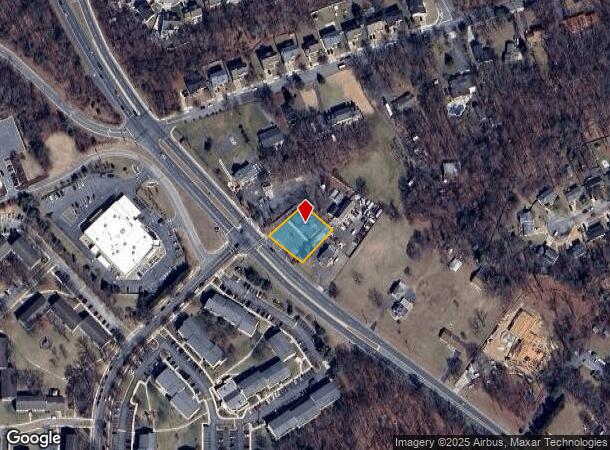
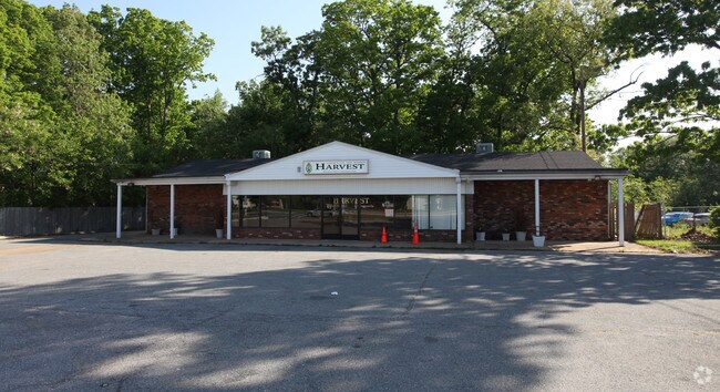
11711 Laurel Bowie Rd, Laurel, MD 20708

NEARBY LISTINGS FOR SALE OR LEASE
Property Detail
11711 Laurel Bowie Rd
Storebuilding
Prince George's
X
Maryland
24033C0065E
0.38 AC
2024
Laurel
2025
Washington, DC
800206
Washington-Arlington-Alexandria, DC-VA-MD-WV
2,640 SF
10-1097484
DEMOGRAPHICS near 11711 Laurel Bowie Rd
1 mile
3 mile
5 mile
2024 Total Population
8,559
42,190
153,992
2029 Population
8,377
41,478
152,286
Pop Growth 2024-2029
(2.13%)
(1.69%)
(1.11%)
Average Age
38
38
38
2024 Total Households
3,196
15,727
56,445
HH Growth 2024-2029
(2.13%)
(1.89%)
(1.25%)
Median Household Inc
$91,872
$81,289
$92,206
Avg Household Size
2.60
2.60
2.60
2024 Avg HH Vehicles
2.00
2.00
2.00
Median Home Value
$419,761
$397,838
$388,233
Median Year Built
1979
1982
1983
Nearby Places
Map Layers
Map Styles
 Street
 Aerial
Transit
 Traffic
 Biking
Places
Listings with unknown addresses are not visible on the map
- Restaurants
- Banks
- Shops
- Fitness
- Groceries
PUBLIC TRANSPORTATION
COMMUTER RAIL
Laurel (Camden Line - Maryland Area Regional Commuter Trains (The MARC))
Drive
Walk
Distance
Laurel (Camden Line - Maryland Area Regional Commuter Trains (The MARC))
8 min
3.9 mi
Muirkirk (Camden Line - Maryland Area Regional Commuter Trains (The MARC))
Drive
Walk
Distance
Muirkirk (Camden Line - Maryland Area Regional Commuter Trains (The MARC))
9 min
4.4 mi
AIRPORT
Baltimore/Washington International Thurgood Marshall
Drive
Walk
Distance
Baltimore/Washington International Thurgood Marshall
23 min
15.1 mi
Ronald Reagan Washington Ntl
Drive
Walk
Distance
Ronald Reagan Washington Ntl
36 min
22.7 mi
Washington Dulles International
Drive
Walk
Distance
Washington Dulles International
65 min
42.3 mi
Freight Ports
Port of Baltimore
Drive
Walk
Distance
Port of Baltimore
32 min
21.4 mi
Nearby Properties
Address
Land Use
TOTAL SIZE
Lot Size
Zoning
Address
Land Use
TOTAL SIZE
Lot Size
Zoning
791,089 SF
10.69 AC
LAUR
Address
Land Use
TOTAL SIZE
Lot Size
Zoning
514,064 SF
7.37 AC
NAC
Address
Land Use
TOTAL SIZE
Lot Size
Zoning
564,165 SF
35.85 AC
RMF12
Address
Land Use
TOTAL SIZE
Lot Size
Zoning
104,067 SF
25.29 AC
RMF20
Address
Land Use
TOTAL SIZE
Lot Size
Zoning
1,849.51 AC
ROS
Address
Land Use
TOTAL SIZE
Lot Size
Zoning
158,316 SF
20.30 AC
LAUR
Address
Land Use
TOTAL SIZE
Lot Size
Zoning
302,887 SF
24.96 AC
LAUR
Address
Land Use
TOTAL SIZE
Lot Size
Zoning
16.36 AC
RMF20
Address
Land Use
TOTAL SIZE
Lot Size
Zoning
1,495.19 AC
ROS
Address
Land Use
TOTAL SIZE
Lot Size
Zoning
15.70 AC
RMF20
Address
Land Use
TOTAL SIZE
Lot Size
Zoning
182,199 SF
43.70 AC
IE
Address
Land Use
TOTAL SIZE
Lot Size
Zoning
11.20 AC
RMF20
Address
Land Use
TOTAL SIZE
Lot Size
Zoning
10.52 AC
RMF20
Address
Land Use
TOTAL SIZE
Lot Size
Zoning
37,872 SF
10.29 AC
RMF20
Address
Land Use
TOTAL SIZE
Lot Size
Zoning
142,372 SF
13.88 AC
LAUR
Address
Land Use
TOTAL SIZE
Lot Size
Zoning
766.09 AC
ROS
Address
Land Use
TOTAL SIZE
Lot Size
Zoning
199 SF
10.20 AC
RMF20
Address
Land Use
TOTAL SIZE
Lot Size
Zoning
212,535 SF
7.98 AC
RMF20
Address
Land Use
TOTAL SIZE
Lot Size
Zoning
1,012.55 AC
ROS
Address
Land Use
TOTAL SIZE
Lot Size
Zoning
365,608 SF
17.01 AC
IE
Address
Land Use
TOTAL SIZE
Lot Size
Zoning
214,396 SF
10.10 AC
RMF20
Address
Land Use
TOTAL SIZE
Lot Size
Zoning
175 SF
11.11 AC
RMF20
Address
Land Use
TOTAL SIZE
Lot Size
Zoning
185 SF
9.10 AC
RMF20
Address
Land Use
TOTAL SIZE
Lot Size
Zoning
251,634 SF
9.27 AC
RMF20
Address
Land Use
TOTAL SIZE
Lot Size
Zoning
258,345 SF
10 AC
RMF20
Address
Land Use
TOTAL SIZE
Lot Size
Zoning
195,700 SF
2.48 AC
IH
Address
Land Use
TOTAL SIZE
Lot Size
Zoning
7.53 AC
RMF20
Address
Land Use
TOTAL SIZE
Lot Size
Zoning
12.92 AC
RMF12
Address
Land Use
TOTAL SIZE
Lot Size
Zoning
12,000 SF
7.91 AC
RMF20
Address
Land Use
TOTAL SIZE
Lot Size
Zoning
6.32 AC
RMF20
The World's #1 Commercial Real Estate Marketplace
Connect with us
© 2026 CoStar Group
The information above has been obtained from sources believed reliable. While we do not doubt its accuracy we have not verified it and make no guarantee, warranty or representation about it. It is your responsibility to independently confirm its accuracy and completeness. Any projections, opinions, assumptions, or estimates used are for example only and do not represent the current or future performance of the property. The value of this transaction to you depends on tax and other factors which should be evaluated by your tax, financial, and legal advisors. You and your advisors should conduct a careful, independent investigation of the property to determine to your satisfaction the suitability of the property for your needs.