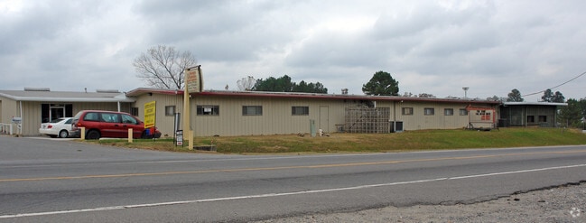
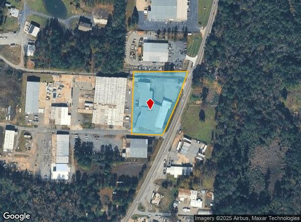
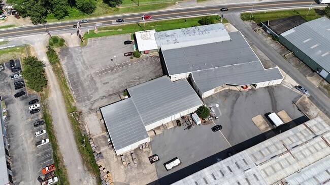
Property Record
11714 Arch St, Little Rock, AR 72206
Current Lease Availabilities
NEARBY LISTINGS FOR SALE OR LEASE
Property Detail
11714 Arch St
35R-009-00-048-00
PT SW SECTION 9-1S-12 MPDA COM NW COR SW SW TH N00*00'00"E50' N88*53'34"E726.61' TO BEG TH CONTINUE N88*53'34"E349.81' TO W R/W HWY TH CONTINUING AL HWY R/W S18*14'09"W248.3' S19*30'17"W196.98' S88*53'57"W200.3' N418.35
Officebuilding
Pulaski
X
Arkansas
05119C0470G
2.66 AC
2025
Outlying Pulaski County
2025
Little Rock/N Little Rock
004001
Little Rock-North Little Rock-Conway, AR
25,397 SF
DEMOGRAPHICS near 11714 Arch St
1 Mile
3 Mile
5 Mile
2024 Total Population
739
20,194
49,528
2029 Population
751
20,325
50,044
Pop Growth 2024-2029
+ 1.62%
+ 0.65%
+ 1.04%
Average Age
43
36
36
2024 Total Households
302
7,584
18,751
HH Growth 2024-2029
+ 1.66%
+ 0.65%
+ 1.01%
Median Household Inc
$37,777
$42,026
$42,926
Avg Household Size
2.40
2.60
2.50
2024 Avg HH Vehicles
2.00
2.00
2.00
Median Home Value
$147,183
$116,139
$104,622
Median Year Built
1975
1976
1975
Nearby Places
- Restaurants
- Banks
- Shops
- Fitness
- Groceries
PUBLIC TRANSPORTATION
COMMUTER RAIL
Little Rock Union Station (Texas Eagle - Amtrak)
DRIVE
WALK
Distance
Little Rock Union Station (Texas Eagle - Amtrak)
16 min
8.6 mi
AIRPORT
Bill and Hillary Clinton Ntl/Adams Field
DRIVE
WALK
Distance
Bill and Hillary Clinton Ntl/Adams Field
16 min
10.2 mi
Freight Ports
Port of Shreveport
DRIVE
WALK
Distance
Port of Shreveport
249 min
230.6 mi
Nearby Properties
Address
Land Use
TOTAL SIZE
Lot Size
Zoning
Address
Land Use
TOTAL SIZE
Lot Size
Zoning
10 SF
29.02 AC
Address
Land Use
TOTAL SIZE
Lot Size
Zoning
550,000 SF
39.66 AC
Address
Land Use
TOTAL SIZE
Lot Size
Zoning
239,345 SF
19.70 AC
Address
Land Use
TOTAL SIZE
Lot Size
Zoning
34,925 SF
12.59 AC
Address
Land Use
TOTAL SIZE
Lot Size
Zoning
41,652 SF
10.86 AC
Address
Land Use
TOTAL SIZE
Lot Size
Zoning
50,433 SF
22.23 AC
Address
Land Use
TOTAL SIZE
Lot Size
Zoning
64,182 SF
17.80 AC
Address
Land Use
TOTAL SIZE
Lot Size
Zoning
59,076 SF
22.27 AC
Address
Land Use
TOTAL SIZE
Lot Size
Zoning
81,021 SF
10.28 AC
Address
Land Use
TOTAL SIZE
Lot Size
Zoning
573,416 SF
57.83 AC
Address
Land Use
TOTAL SIZE
Lot Size
Zoning
1,233 SF
6.19 AC
Address
Land Use
TOTAL SIZE
Lot Size
Zoning
38,640 SF
11.48 AC
Address
Land Use
TOTAL SIZE
Lot Size
Zoning
27,760 SF
9.95 AC
Address
Land Use
TOTAL SIZE
Lot Size
Zoning
4,000 SF
23.11 AC
Address
Land Use
TOTAL SIZE
Lot Size
Zoning
70,281 SF
20.36 AC
Address
Land Use
TOTAL SIZE
Lot Size
Zoning
53,292 SF
9.24 AC
Address
Land Use
TOTAL SIZE
Lot Size
Zoning
Address
Land Use
TOTAL SIZE
Lot Size
Zoning
22,008 SF
5 AC
Address
Land Use
TOTAL SIZE
Lot Size
Zoning
130,926 SF
10.91 AC
Address
Land Use
TOTAL SIZE
Lot Size
Zoning
80,982 SF
74.25 AC
Address
Land Use
TOTAL SIZE
Lot Size
Zoning
24,143 SF
4.48 AC
Address
Land Use
TOTAL SIZE
Lot Size
Zoning
Address
Land Use
TOTAL SIZE
Lot Size
Zoning
2,740 SF
2.07 AC
Address
Land Use
TOTAL SIZE
Lot Size
Zoning
47,445 SF
3.59 AC
Address
Land Use
TOTAL SIZE
Lot Size
Zoning
1,112 SF
36.04 AC
Address
Land Use
TOTAL SIZE
Lot Size
Zoning
2,046 SF
6.09 AC
Address
Land Use
TOTAL SIZE
Lot Size
Zoning
16,345 SF
3.92 AC
Address
Land Use
TOTAL SIZE
Lot Size
Zoning
108,000 SF
7.46 AC
Address
Land Use
TOTAL SIZE
Lot Size
Zoning
137,159 SF
6.79 AC
Address
Land Use
TOTAL SIZE
Lot Size
Zoning
38,125 SF
23.40 AC
The World's #1 Commercial Real Estate Marketplace
Connect with us
© 2025 CoStar Group
The information above has been obtained from sources believed reliable. While we do not doubt its accuracy we have not verified it and make no guarantee, warranty or representation about it. It is your responsibility to independently confirm its accuracy and completeness. Any projections, opinions, assumptions, or estimates used are for example only and do not represent the current or future performance of the property. The value of this transaction to you depends on tax and other factors which should be evaluated by your tax, financial, and legal advisors. You and your advisors should conduct a careful, independent investigation of the property to determine to your satisfaction the suitability of the property for your needs.