Property Record
1172 Bent Oaks Dr, Denton, TX 76210


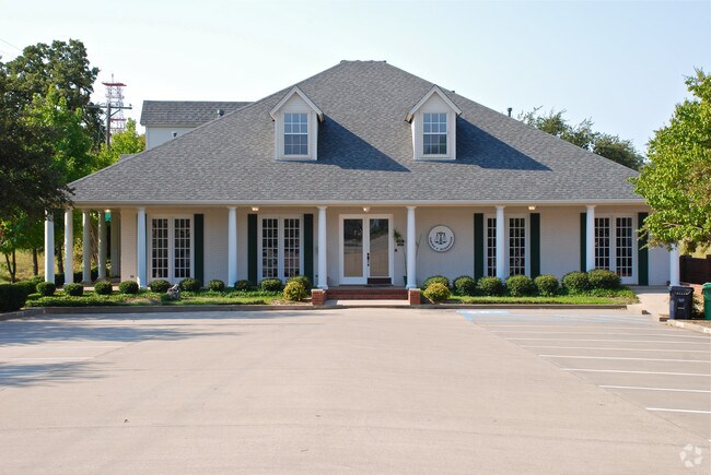
Property Detail
1172 Bent Oaks Dr
Dallas-Fort Worth-Arlington, TX
BENTOAKS BLK 1 LOT 1(PT)
R103330
Denton
Commercialnec
Texas
B and X Area of moderate flood hazard, usually the area between the limits of the 100-year and 500-year floods.
1
2024
0.58 AC
2025
Denton
021304
Dallas/Ft Worth
4,948 SF
NEARBY LISTINGS FOR SALE OR LEASE
DEMOGRAPHICS near 1172 Bent Oaks Dr
1 mile
3 mile
5 mile
2025 Total Population
13,197
83,669
174,641
2030 Population
14,794
93,728
195,960
Pop Growth 2025-2030
+ 12.10%
+ 12.02%
+ 12.21%
Average Age
42
37
37
2025 Total Households
4,914
31,703
65,954
HH Growth 2025-2030
+ 12.41%
+ 12.40%
+ 12.62%
Median Household Inc
$111,836
$75,241
$77,900
Avg Household Size
2.60
2.50
2.50
2025 Avg HH Vehicles
2.00
2.00
2.00
Median Home Value
$413,324
$388,441
$388,903
Median Year Built
2002
2000
1998
Nearby Places
Map Layers
Map Styles
 Street
 Aerial
Transit
 Traffic
 Biking
Places
Listings with unknown addresses are not visible on the map
- Restaurants
- Banks
- Shops
- Fitness
- Groceries
PUBLIC TRANSPORTATION
COMMUTER RAIL
Drive
Walk
Distance
7 min
2.6 mi
Drive
Walk
Distance
9 min
4.1 mi
AIRPORT
Dallas-Fort Worth International
Drive
Walk
Distance
Dallas-Fort Worth International
33 min
24.5 mi
Dallas Love Field
Drive
Walk
Distance
Dallas Love Field
45 min
33.6 mi
Nearby Properties
Address
Land Use
TOTAL SIZE
Lot Size
Zoning
Address
Land Use
TOTAL SIZE
Lot Size
Zoning
337,730 SF
65.39 AC
Address
Land Use
TOTAL SIZE
Lot Size
Zoning
394,618 SF
12.29 AC
Address
Land Use
TOTAL SIZE
Lot Size
Zoning
387,383 SF
27.58 AC
Address
Land Use
TOTAL SIZE
Lot Size
Zoning
386,056 SF
81.56 AC
Address
Land Use
TOTAL SIZE
Lot Size
Zoning
398,028 SF
18.89 AC
Address
Land Use
TOTAL SIZE
Lot Size
Zoning
310,952 SF
56.11 AC
Address
Land Use
TOTAL SIZE
Lot Size
Zoning
361,731 SF
15.96 AC
Address
Land Use
TOTAL SIZE
Lot Size
Zoning
184,710 SF
16.82 AC
Address
Land Use
TOTAL SIZE
Lot Size
Zoning
310,772 SF
11.77 AC
Address
Land Use
TOTAL SIZE
Lot Size
Zoning
278,316 SF
17.81 AC
30G
Address
Land Use
TOTAL SIZE
Lot Size
Zoning
338,378 SF
11.89 AC
Address
Land Use
TOTAL SIZE
Lot Size
Zoning
294,021 SF
30.81 AC
Address
Land Use
TOTAL SIZE
Lot Size
Zoning
208,582 SF
8.58 AC
Address
Land Use
TOTAL SIZE
Lot Size
Zoning
191,512 SF
8.04 AC
Address
Land Use
TOTAL SIZE
Lot Size
Zoning
251,208 SF
9.29 AC
Address
Land Use
TOTAL SIZE
Lot Size
Zoning
447,180 SF
30.54 AC
Address
Land Use
TOTAL SIZE
Lot Size
Zoning
326,832 SF
19.54 AC
30G
Address
Land Use
TOTAL SIZE
Lot Size
Zoning
246,287 SF
9.92 AC
Address
Land Use
TOTAL SIZE
Lot Size
Zoning
243,397 SF
14.43 AC
Address
Land Use
TOTAL SIZE
Lot Size
Zoning
286,971 SF
12.75 AC
Address
Land Use
TOTAL SIZE
Lot Size
Zoning
195,121 SF
10.16 AC
30G
Address
Land Use
TOTAL SIZE
Lot Size
Zoning
226,040 SF
19.51 AC
Address
Land Use
TOTAL SIZE
Lot Size
Zoning
123,133 SF
13.05 AC
Address
Land Use
TOTAL SIZE
Lot Size
Zoning
281,644 SF
4.50 AC
30G
Address
Land Use
TOTAL SIZE
Lot Size
Zoning
198,755 SF
10.57 AC
Address
Land Use
TOTAL SIZE
Lot Size
Zoning
229,968 SF
6.93 AC
Address
Land Use
TOTAL SIZE
Lot Size
Zoning
232,942 SF
12.58 AC
30G
Address
Land Use
TOTAL SIZE
Lot Size
Zoning
165,474 SF
8.65 AC
Address
Land Use
TOTAL SIZE
Lot Size
Zoning
176,838 SF
15.64 AC
Address
Land Use
TOTAL SIZE
Lot Size
Zoning
221,051 SF
19.24 AC
The World's #1 Commercial Real Estate Marketplace
Connect with us
© 2026 CoStar Group
The information above has been obtained from sources believed reliable. While we do not doubt its accuracy we have not verified it and make no guarantee, warranty or representation about it. It is your responsibility to independently confirm its accuracy and completeness. Any projections, opinions, assumptions, or estimates used are for example only and do not represent the current or future performance of the property. The value of this transaction to you depends on tax and other factors which should be evaluated by your tax, financial, and legal advisors. You and your advisors should conduct a careful, independent investigation of the property to determine to your satisfaction the suitability of the property for your needs.