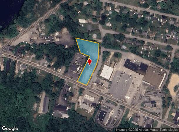
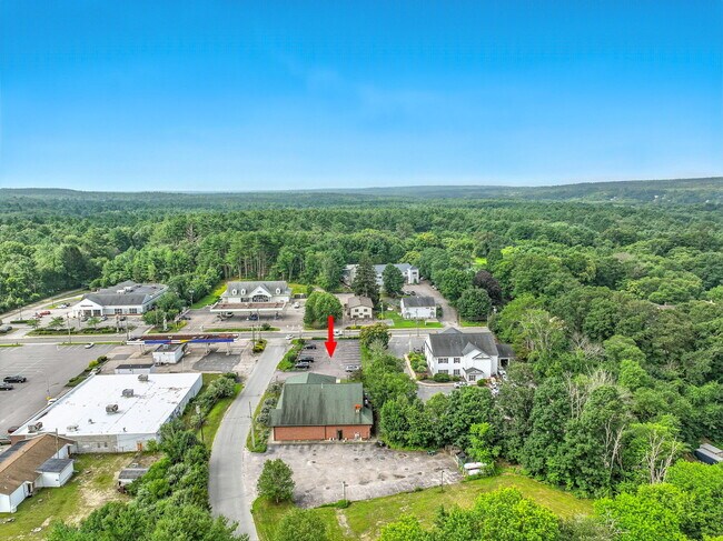
Property Record
1172 Main St, Wyoming, RI 02898
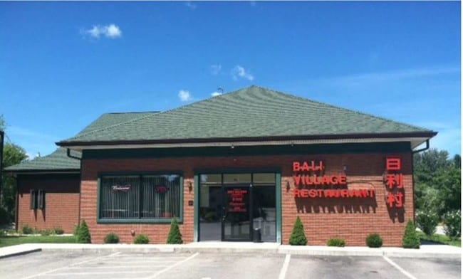
This Property Is For Sale
NEARBY LISTINGS FOR SALE OR LEASE
Property Detail
1172 Main St
Commercialbuilding
Washington
X
Rhode Island
44009C0064J
1.30 AC
2024
Washington County
2024
Providence
050600
Providence-Warwick, RI-MA
5,320 SF
RICH-000004B-000033
DEMOGRAPHICS near 1172 Main St
1 mile
3 mile
5 mile
2024 Total Population
990
5,284
11,014
2029 Population
966
5,153
10,781
Pop Growth 2024-2029
(2.42%)
(2.48%)
(2.12%)
Average Age
42
43
43
2024 Total Households
378
2,046
4,242
HH Growth 2024-2029
(2.91%)
(2.74%)
(2.43%)
Median Household Inc
$88,636
$91,275
$95,501
Avg Household Size
2.50
2.50
2.50
2024 Avg HH Vehicles
2.00
2.00
2.00
Median Home Value
$359,615
$363,888
$371,871
Median Year Built
1982
1981
1981
Nearby Places
Map Layers
Map Styles
 Street
 Aerial
Transit
 Traffic
 Biking
Places
Listings with unknown addresses are not visible on the map
- Restaurants
- Banks
- Shops
- Fitness
- Groceries
PUBLIC TRANSPORTATION
COMMUTER RAIL
Drive
Walk
Distance
20 min
8.9 mi
AIRPORT
Rhode Island Tf Green International
Drive
Walk
Distance
Rhode Island Tf Green International
38 min
25.7 mi
Freight Ports
Port of Davisville, RI
Drive
Walk
Distance
Port of Davisville, RI
39 min
25.9 mi
Nearby Properties
Address
Land Use
TOTAL SIZE
Lot Size
Zoning
Address
Land Use
TOTAL SIZE
Lot Size
Zoning
4.65 AC
RFR8
Address
Land Use
TOTAL SIZE
Lot Size
Zoning
40,020 SF
10.17 AC
Address
Land Use
TOTAL SIZE
Lot Size
Zoning
61,929 SF
9.35 AC
Address
Land Use
TOTAL SIZE
Lot Size
Zoning
30,944 SF
Address
Land Use
TOTAL SIZE
Lot Size
Zoning
850.10 AC
Address
Land Use
TOTAL SIZE
Lot Size
Zoning
96.91 AC
Address
Land Use
TOTAL SIZE
Lot Size
Zoning
2,231 SF
Address
Land Use
TOTAL SIZE
Lot Size
Zoning
4.78 AC
R-1
Address
Land Use
TOTAL SIZE
Lot Size
Zoning
1,735 SF
469.70 AC
Address
Land Use
TOTAL SIZE
Lot Size
Zoning
4.82 AC
RS
Address
Land Use
TOTAL SIZE
Lot Size
Zoning
43,781 SF
38.79 AC
RS
Address
Land Use
TOTAL SIZE
Lot Size
Zoning
177.03 AC
Address
Land Use
TOTAL SIZE
Lot Size
Zoning
1,792 SF
Address
Land Use
TOTAL SIZE
Lot Size
Zoning
150.99 AC
MFG
Address
Land Use
TOTAL SIZE
Lot Size
Zoning
208.60 AC
Address
Land Use
TOTAL SIZE
Lot Size
Zoning
1,792 SF
Address
Land Use
TOTAL SIZE
Lot Size
Zoning
3,024 SF
Address
Land Use
TOTAL SIZE
Lot Size
Zoning
423.80 AC
Address
Land Use
TOTAL SIZE
Lot Size
Zoning
1,578 SF
Address
Land Use
TOTAL SIZE
Lot Size
Zoning
21,258 SF
9.14 AC
C
Address
Land Use
TOTAL SIZE
Lot Size
Zoning
48.30 AC
Address
Land Use
TOTAL SIZE
Lot Size
Zoning
21,809 SF
39.90 AC
RS
Address
Land Use
TOTAL SIZE
Lot Size
Zoning
1,200 SF
Address
Land Use
TOTAL SIZE
Lot Size
Zoning
1,764 SF
Address
Land Use
TOTAL SIZE
Lot Size
Zoning
13,144 SF
1.96 AC
Address
Land Use
TOTAL SIZE
Lot Size
Zoning
1,920 SF
Address
Land Use
TOTAL SIZE
Lot Size
Zoning
Address
Land Use
TOTAL SIZE
Lot Size
Zoning
12,100 SF
2.21 AC
Address
Land Use
TOTAL SIZE
Lot Size
Zoning
1,920 SF
Address
Land Use
TOTAL SIZE
Lot Size
Zoning
10,189 SF
1.65 AC
R-1
The World's #1 Commercial Real Estate Marketplace
Connect with us
© 2026 CoStar Group
The information above has been obtained from sources believed reliable. While we do not doubt its accuracy we have not verified it and make no guarantee, warranty or representation about it. It is your responsibility to independently confirm its accuracy and completeness. Any projections, opinions, assumptions, or estimates used are for example only and do not represent the current or future performance of the property. The value of this transaction to you depends on tax and other factors which should be evaluated by your tax, financial, and legal advisors. You and your advisors should conduct a careful, independent investigation of the property to determine to your satisfaction the suitability of the property for your needs.