Property Record
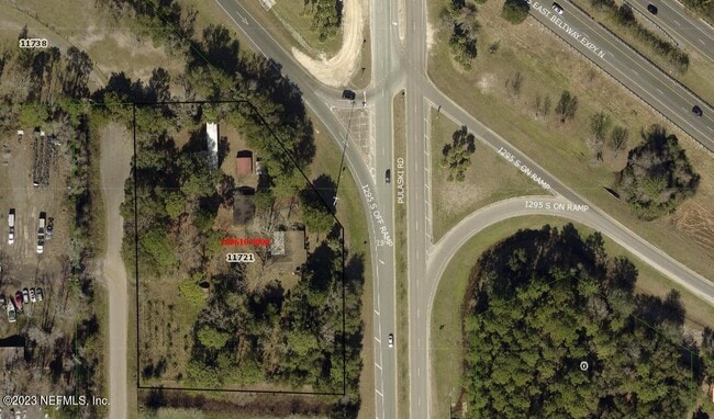
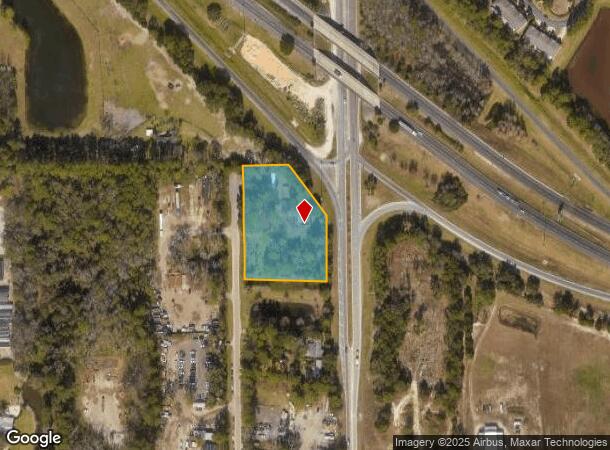
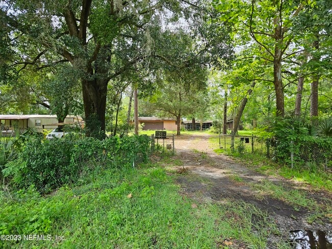
11721 Houle Rd, Jacksonville, FL 32218
This Property Is For Sale
NEARBY LISTINGS FOR SALE OR LEASE
Property Detail
11721 Houle Rd
Jacksonville, FL
Raymond Estates
109610-0000
Duval
Sfr
Florida
X
2.24 AC
12031C0203J
Northeast Jacksonville
2,716 SF
Jacksonville (Florida)
DEMOGRAPHICS near 11721 Houle Rd
1 Mile
3 Mile
5 Mile
2024 Total Population
3,675
32,176
77,550
2029 Population
3,852
34,263
82,024
Pop Growth 2024-2029
+ 4.82%
+ 6.49%
+ 5.77%
Average Age
37
38
38
2024 Total Households
1,358
12,435
29,628
HH Growth 2024-2029
+ 5.08%
+ 6.79%
+ 6.02%
Median Household Inc
$69,634
$68,560
$59,356
Avg Household Size
2.70
2.50
2.60
2024 Avg HH Vehicles
2.00
2.00
2.00
Median Home Value
$253,480
$248,229
$237,329
Median Year Built
2000
1999
1992
Nearby Places
Map Layers
Map Styles
 Street
 Aerial
- Restaurants
- Banks
- Shops
- Fitness
- Groceries
PUBLIC TRANSPORTATION
AIRPORT
Jacksonville International
DRIVE
WALK
Distance
Jacksonville International
14 min
7.3 mi
Freight Ports
Jacksonville Port
DRIVE
WALK
Distance
Jacksonville Port
19 min
9.2 mi
Nearby Properties
Address
Land Use
TOTAL SIZE
Lot Size
Zoning
Address
Land Use
TOTAL SIZE
Lot Size
Zoning
344,800 SF
35.11 AC
PUD
Address
Land Use
TOTAL SIZE
Lot Size
Zoning
1,064,086 SF
87.81 AC
IL
Address
Land Use
TOTAL SIZE
Lot Size
Zoning
1,009,974 SF
62.96 AC
PUD
Address
Land Use
TOTAL SIZE
Lot Size
Zoning
350,831 SF
23.77 AC
IH
Address
Land Use
TOTAL SIZE
Lot Size
Zoning
371,466 SF
42.67 AC
PUD
Address
Land Use
TOTAL SIZE
Lot Size
Zoning
1,170,252 SF
201.15 AC
IH
Address
Land Use
TOTAL SIZE
Lot Size
Zoning
823,286 SF
53.36 AC
IL
Address
Land Use
TOTAL SIZE
Lot Size
Zoning
1,678,675 SF
73.48 AC
IL
Address
Land Use
TOTAL SIZE
Lot Size
Zoning
226,421 SF
1.89 AC
PUD
Address
Land Use
TOTAL SIZE
Lot Size
Zoning
403,103 SF
31.05 AC
PUD
Address
Land Use
TOTAL SIZE
Lot Size
Zoning
307,351 SF
34.25 AC
PUD
Address
Land Use
TOTAL SIZE
Lot Size
Zoning
625,900 SF
49.80 AC
IBP
Address
Land Use
TOTAL SIZE
Lot Size
Zoning
816,362 SF
54.68 AC
IH
Address
Land Use
TOTAL SIZE
Lot Size
Zoning
328,039 SF
18.88 AC
PUD
Address
Land Use
TOTAL SIZE
Lot Size
Zoning
588,053 SF
33.10 AC
PUD
Address
Land Use
TOTAL SIZE
Lot Size
Zoning
556,862 SF
27.25 AC
IL
Address
Land Use
TOTAL SIZE
Lot Size
Zoning
556,016 SF
25.95 AC
IH
Address
Land Use
TOTAL SIZE
Lot Size
Zoning
205,093 SF
10.93 AC
CRO
Address
Land Use
TOTAL SIZE
Lot Size
Zoning
237,807 SF
13.52 AC
CRO
Address
Land Use
TOTAL SIZE
Lot Size
Zoning
477,945 SF
31.03 AC
CCG-2
Address
Land Use
TOTAL SIZE
Lot Size
Zoning
740,260 SF
59.11 AC
IL
Address
Land Use
TOTAL SIZE
Lot Size
Zoning
428,690 SF
29.57 AC
IL
Address
Land Use
TOTAL SIZE
Lot Size
Zoning
317,695 SF
15.88 AC
PUD
Address
Land Use
TOTAL SIZE
Lot Size
Zoning
317,815 SF
17.56 AC
PUD
Address
Land Use
TOTAL SIZE
Lot Size
Zoning
163,276 SF
8.39 AC
PUD
Address
Land Use
TOTAL SIZE
Lot Size
Zoning
408,384 SF
23.77 AC
IL
Address
Land Use
TOTAL SIZE
Lot Size
Zoning
353,240 SF
26.17 AC
PUD
Address
Land Use
TOTAL SIZE
Lot Size
Zoning
841,077 SF
241.17 AC
PUD
Address
Land Use
TOTAL SIZE
Lot Size
Zoning
324,922 SF
19.11 AC
PUD
Address
Land Use
TOTAL SIZE
Lot Size
Zoning
478,803 SF
24.43 AC
IL
The World's #1 Commercial Real Estate Marketplace
Connect with us
© 2025 CoStar Group
The information above has been obtained from sources believed reliable. While we do not doubt its accuracy we have not verified it and make no guarantee, warranty or representation about it. It is your responsibility to independently confirm its accuracy and completeness. Any projections, opinions, assumptions, or estimates used are for example only and do not represent the current or future performance of the property. The value of this transaction to you depends on tax and other factors which should be evaluated by your tax, financial, and legal advisors. You and your advisors should conduct a careful, independent investigation of the property to determine to your satisfaction the suitability of the property for your needs.