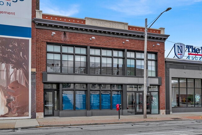
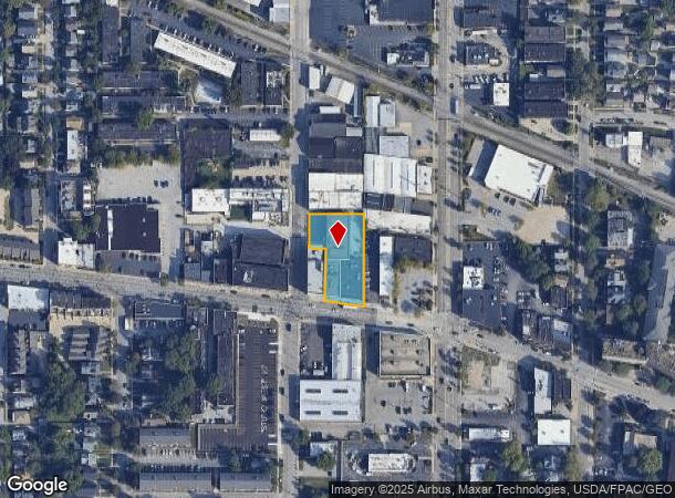
Property Record
11728 Detroit Ave, Lakewood, OH 44107

NEARBY LISTINGS FOR SALE OR LEASE
Property Detail
11728 Detroit Ave
Cleveland-Elyria, OH
S/R Add
312-33-017
S/L PCL C VOL 322 PG 76 FF 73.6 5 D 243.52 0.6522 AC OL 21 2004 S/R ADDITIONAL PARCEL 312-33-018 LISTED WITH MB312 PG33 MB322 PG76
Storebuilding
Cuyahoga
X
Ohio
39035C0157F
21
2024
0.65 AC
2024
West
160602
Cleveland
28,208 SF
DEMOGRAPHICS near 11728 Detroit Ave
1 Mile
3 Mile
5 Mile
2024 Total Population
24,788
123,255
252,729
2029 Population
24,291
119,317
245,737
Pop Growth 2024-2029
(2.01%)
(3.20%)
(2.77%)
Average Age
40
38
39
2024 Total Households
14,045
57,658
118,754
HH Growth 2024-2029
(2.06%)
(3.27%)
(2.71%)
Median Household Inc
$47,915
$49,354
$50,614
Avg Household Size
1.70
2.00
2.00
2024 Avg HH Vehicles
1.00
1.00
1.00
Median Home Value
$184,295
$159,569
$154,245
Median Year Built
1949
1947
1948
Nearby Places
Map Layers
Map Styles
 Street
 Aerial
- Restaurants
- Banks
- Shops
- Fitness
- Groceries
PUBLIC TRANSPORTATION
TRANSIT/SUBWAY
W 117Th St-Madison Av Station (Red Line - Greater Cleveland Regional Transit Authority)
DRIVE
WALK
Distance
W 117Th St-Madison Av Station (Red Line - Greater Cleveland Regional Transit Authority)
2 min
12 min
0.6 mi
West 117 - Madison (Red Line - Greater Cleveland Regional Transit Authority Rapid Transit (The Rapid))
DRIVE
WALK
Distance
West 117 - Madison (Red Line - Greater Cleveland Regional Transit Authority Rapid Transit (The Rapid))
2 min
12 min
0.6 mi
West Blvd-Cudell Station (Red Line - Greater Cleveland Regional Transit Authority)
DRIVE
WALK
Distance
West Blvd-Cudell Station (Red Line - Greater Cleveland Regional Transit Authority)
4 min
18 min
1.0 mi
West Boulevard - Cudell (Red Line - Greater Cleveland Regional Transit Authority Rapid Transit (The Rapid))
DRIVE
WALK
Distance
West Boulevard - Cudell (Red Line - Greater Cleveland Regional Transit Authority Rapid Transit (The Rapid))
4 min
18 min
1.0 mi
COMMUTER RAIL
Cleveland Lakefront Station (Blue Line - Greater Cleveland Regional Transit Authority Rapid Transit (The Rapid), Green Line - Greater Cleveland Regional Transit Authority Rapid Transit (The Rapid))
DRIVE
WALK
Distance
Cleveland Lakefront Station (Blue Line - Greater Cleveland Regional Transit Authority Rapid Transit (The Rapid), Green Line - Greater Cleveland Regional Transit Authority Rapid Transit (The Rapid))
15 min
6.4 mi
AIRPORT
Cleveland-Hopkins International
DRIVE
WALK
Distance
Cleveland-Hopkins International
20 min
8.9 mi
Freight Ports
Port of Toledo
DRIVE
WALK
Distance
Port of Toledo
131 min
109.2 mi
SALE & LEASE HISTORY
LISTING DATE
SALE/LEASE

Oct 02, 2023
For Lease
Nov 28, 2023
For Sale
Nearby Properties
Address
Land Use
TOTAL SIZE
Lot Size
Zoning
Address
Land Use
TOTAL SIZE
Lot Size
Zoning
5,100 SF
9.41 AC
GI
Address
Land Use
TOTAL SIZE
Lot Size
Zoning
187 SF
20.90 AC
PG
Address
Land Use
TOTAL SIZE
Lot Size
Zoning
518,244 SF
21.80 AC
Address
Land Use
TOTAL SIZE
Lot Size
Zoning
208,209 SF
12.10 AC
1F
Address
Land Use
TOTAL SIZE
Lot Size
Zoning
164,294 SF
13.81 AC
GI
Address
Land Use
TOTAL SIZE
Lot Size
Zoning
200,874 SF
3.30 AC
LR
Address
Land Use
TOTAL SIZE
Lot Size
Zoning
168,750 SF
18.55 AC
GI
Address
Land Use
TOTAL SIZE
Lot Size
Zoning
258,852 SF
5.20 AC
MF2
Address
Land Use
TOTAL SIZE
Lot Size
Zoning
155,896 SF
5.03 AC
Address
Land Use
TOTAL SIZE
Lot Size
Zoning
59,913 SF
0.92 AC
LR
Address
Land Use
TOTAL SIZE
Lot Size
Zoning
128,902 SF
7.12 AC
PD
Address
Land Use
TOTAL SIZE
Lot Size
Zoning
126,661 SF
7.07 AC
PD
Address
Land Use
TOTAL SIZE
Lot Size
Zoning
56,212 SF
2.69 AC
Address
Land Use
TOTAL SIZE
Lot Size
Zoning
278,256 SF
0.81 AC
C1
Address
Land Use
TOTAL SIZE
Lot Size
Zoning
228,712 SF
10.10 AC
C3
Address
Land Use
TOTAL SIZE
Lot Size
Zoning
64,000 SF
4.05 AC
Address
Land Use
TOTAL SIZE
Lot Size
Zoning
144,307 SF
2.99 AC
MF2
Address
Land Use
TOTAL SIZE
Lot Size
Zoning
105,632 SF
1.01 AC
MF3+
Address
Land Use
TOTAL SIZE
Lot Size
Zoning
57,744 SF
2.30 AC
Address
Land Use
TOTAL SIZE
Lot Size
Zoning
169,865 SF
28.66 AC
1F
Address
Land Use
TOTAL SIZE
Lot Size
Zoning
155,268 SF
4.86 AC
2F
Address
Land Use
TOTAL SIZE
Lot Size
Zoning
300,816 SF
7.04 AC
MF-1
Address
Land Use
TOTAL SIZE
Lot Size
Zoning
97,264 SF
4.16 AC
2F
Address
Land Use
TOTAL SIZE
Lot Size
Zoning
76,298 SF
3.41 AC
2F
Address
Land Use
TOTAL SIZE
Lot Size
Zoning
91,324 SF
0.63 AC
LR
Address
Land Use
TOTAL SIZE
Lot Size
Zoning
61,406 SF
3.44 AC
C2
Address
Land Use
TOTAL SIZE
Lot Size
Zoning
91,080 SF
0.71 AC
LR
Address
Land Use
TOTAL SIZE
Lot Size
Zoning
126,858 SF
11.19 AC
GR
Address
Land Use
TOTAL SIZE
Lot Size
Zoning
295,665 SF
1.73 AC
C2
Address
Land Use
TOTAL SIZE
Lot Size
Zoning
72,972 SF
3 AC
C4
The World's #1 Commercial Real Estate Marketplace
Connect with us
© 2025 CoStar Group
The information above has been obtained from sources believed reliable. While we do not doubt its accuracy we have not verified it and make no guarantee, warranty or representation about it. It is your responsibility to independently confirm its accuracy and completeness. Any projections, opinions, assumptions, or estimates used are for example only and do not represent the current or future performance of the property. The value of this transaction to you depends on tax and other factors which should be evaluated by your tax, financial, and legal advisors. You and your advisors should conduct a careful, independent investigation of the property to determine to your satisfaction the suitability of the property for your needs.